Weather School / Unit 1 · The Sky's Machinery / Lesson 1
How a Cloud Forms.
By the rock. August 7, 2026. Grounded in National Weather Service science; imagery from NOAA, public domain. Suitable for classrooms and other curious humans.
The short version
A cloud forms when rising air cools to its dew point and its invisible water vapor condenses onto microscopic particles, becoming billions of visible droplets. The rise does the cooling, the cooling does the condensing, and the height where that happens, the lifting condensation level, is why clouds so often share one flat bottom.
Air has to rise
Every cloud begins with an ascent. Air near the ground picks up water vapor from oceans, lakes, soil, and leaves, but vapor is invisible; humid air looks exactly like dry air. To turn that hidden moisture into a cloud, the air has to be lifted, and the atmosphere has four favorite ways to lift it: convection, where sun-warmed ground heats bubbles of air that float upward like a lava lamp; orographic lift, where wind runs into a mountainside and has nowhere to go but up; frontal lift, where a wedge of dense cold air shovels warmer air over itself; and convergence, where winds collide at the surface and the pileup squeezes air upward.
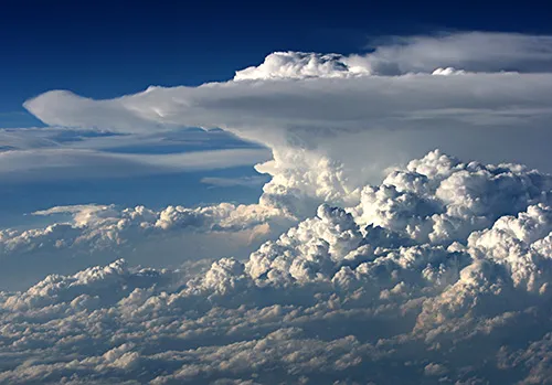
Convection's masterpiece: a cumulonimbus, built by one strong updraft. Note the flat base; this lesson explains it. Photo: NOAA National Weather Service JetStream, public domain.
Rising air cools itself
Here is the engine of the whole process: rising air cools with no refrigeration required. Air pressure falls with altitude, so a rising parcel of air expands, and expanding costs energy. The parcel pays that bill out of its own internal heat, cooling at a remarkably reliable rate of about 5.5 degrees Fahrenheit for every thousand feet of climb (9.8 degrees Celsius per kilometer), called the dry adiabatic lapse rate. Nothing removes the heat; the parcel spends it on expanding. Meanwhile the parcel's dew point, the temperature at which its vapor saturates, falls only slightly as it rises. Temperature races downward, dew point ambles, and the two are on a collision course.
The height where clouds are born
The altitude where the parcel's falling temperature meets its dew point is called the lifting condensation level, and it is one of the most satisfying numbers in meteorology because you can estimate it from two readings taken in your own backyard. The rule of thumb: the cloud base sits roughly 228 feet up for every degree Fahrenheit of spread between temperature and dew point (about 125 meters per degree Celsius). A muggy day with a small spread makes low, close ceilings; a dry desert afternoon with a 40 degree spread has to lift air nearly two miles before any cloud can form, which is why desert cumulus float so extravagantly high. And because the spread is roughly uniform across an air mass, every rising parcel saturates at about the same altitude: the neighborhood's clouds all form on one invisible floor, which is why cumulus bases look ruled flat.
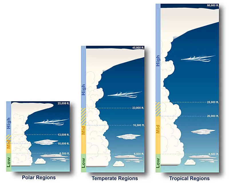
Where clouds live: the high cirro- family, the mid-level alto- family, and the low clouds, sorted by the altitudes where they condense. Diagram: NOAA National Weather Service JetStream, public domain.
Every droplet needs a seat
Saturated air still needs one more thing: something to condense onto. Water vapor is remarkably reluctant to form droplets from scratch; in perfectly clean air it can be stretched far past saturation and simply refuse. The real atmosphere never asks it to. Every cubic inch of sky carries thousands of microscopic particles, sea salt, dust, pollen, smoke, called cloud condensation nuclei, and vapor condenses onto them the moment saturation arrives. The result is a crowd of droplets each about ten to twenty micrometers across, so small that a million of them must merge to build one respectable raindrop. Condensation also releases latent heat, warming the parcel slightly, which is the secret fuel that lets thunderstorm updrafts keep accelerating: every drop the storm condenses buys it another push upward.
Why clouds take different shapes
The recipe never changes; the choreography does. When lift comes as buoyant convective bubbles, each bubble builds its own tower with sharp cauliflower edges: cumulus, and, with enough energy, cumulonimbus. When an entire layer of air is lifted gently and evenly, as along a warm front, it saturates all at once into a smooth featureless sheet: stratus. High, cold altitudes build their clouds from ice crystals instead of droplets, giving the cirrus family its wispy combed look. Every named cloud in the atlas is just this lesson's physics performed at a different altitude, a different vigor, and a different temperature.
The Recipe
Cloud in a Jar
About 10 minutes · Ages 6 and up, an adult strikes the match · Mess: low · Makes: one small cloud, briefly
Ingredients
A clear glass jar with a lidA washed pasta sauce jar is perfect. Wide mouth beats narrow.Or buy a jar
Hot water, about a cupHot from the tap is enough. It does not need to boil.
Ice cubes, enough to fill the lidYour freezer. The colder the better.
One matchOr a single quick spritz of hairspray. This is the secret ingredient: it supplies the condensation nuclei.
A flashlightOptional, but a beam through the side makes the cloud far easier to see. Your phone works.
Method
Pour the hot water into the jar, about a third full. Swirl it so the glass warms and the air inside fills with invisible water vapor.
Turn the lid upside down, rest it on the mouth of the jar, and pile it with ice. You have just built a cold ceiling.
Wait about twenty seconds while the air near the top chills.
Lift the lid, drop in a struck-and-blown-out match so a puff of smoke enters, and put the icy lid straight back on.
Watch. A cloud forms inside the jar within seconds. Shine the flashlight through the side to see it swirl, then lift the lid and let it escape.
An adult handles the match. Hot water, not boiling. The jar gets warm.
If you want to keep measuring
Nothing here is required for the experiment. The rock mentions them only because a jar cloud lasts ten seconds and a backyard record lasts years.
A rain gaugeThe single most useful instrument a household can own, and the one that lets you grade a forecast honestly. Simple plastic ones work as well as expensive ones.Find one
An outdoor thermometer with humidityTemperature and dew point together are what the simulator above runs on. Any model that reads both is enough.Find one
What just happened: this is the whole lesson in a jar. The hot water loaded the air with vapor, the iced lid cooled that air to its dew point, and the smoke gave the vapor something to condense onto. Rise, cool, condense, on a particle. Outdoors, the rising is done by the sun or a mountain or a front instead of a jar, and the particles are salt and dust instead of smoke. The physics does not know the difference.
Ingredient links go to Amazon searches, not to any particular seller, and the rock picks by what does the job rather than what pays best. As an Amazon Associate I earn from qualifying purchases. Nothing is tracked on this page: the link does nothing until you choose to click it. The rock explains.
The simulator: steer today's cloud base
Set the ground temperature and dew point, exactly the two numbers on this site's front page, and watch where the cloud is born. The math is the real forecaster's rule of thumb, computed live.
84 F
62 F
Did it stick? Five questions.
Questions people actually ask
Why are clouds flat on the bottom?
Because the lifting condensation level is a nearly uniform altitude for a given air mass on a given day. Every rising parcel saturates at about the same height, so every cloud in the neighborhood is born on the same invisible floor.
What is a cloud actually made of?
Liquid droplets or ice crystals around ten to twenty micrometers across, condensed onto microscopic nuclei. A cloud is not water vapor; vapor is invisible. A cloud is the vapor's condensed, visible retirement.
Why do clouds float if water is heavier than air?
The droplets are so small they fall at only centimeters per second, and the air that built the cloud is rising faster than that. A cloud is less an object floating than a region where droplets are made faster than they can leave.
Can a cloud form without dust or other particles?
Effectively no. Without nuclei, vapor needs enormous supersaturation to condense on its own. The real sky always carries salt, dust, pollen, and smoke enough that it never has to try.
Why puffy clouds one day and a gray sheet another?
It depends on how the air rises: buoyant bubbles build separate cumulus towers, while a whole layer lifted gently condenses into smooth stratus. Same physics, different choreography.
Take it to class
Free for any classroom or kitchen table: print it, copy it, staple it. The worksheet carries the recipe, an observation prompt, the five questions, and an answer key for whoever is teaching.