THE WEATHER BEAT · OCT 16
Severe Thunderstorm Watch for Philadelphia, Harrisburg, Baltimore and Washington until 8 p.m. as a fast cold front crosses the Mid-Atlantic
Watch 686 runs until 8 p.m. EDT from central Pennsylvania to northern Virginia, with damaging gusts the main risk and a freeze possible Saturday night.

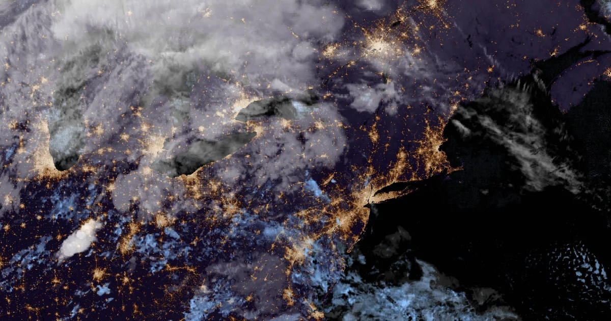
Key points
- Severe Thunderstorm Watch 686 runs until 8 p.m. EDT Friday. It covers 44 Pennsylvania counties, one county in New York, 16 in Maryland, 25 in Virginia and the District of Columbia, including Philadelphia, Harrisburg, Scranton, Baltimore and Washington.
- As of its 11:29 a.m. CDT outlook, the Storm Prediction Center expected a fast, low-topped line of storms along a cold front. Damaging wind is the main risk, with "perhaps a tornado or two," from the Mid-Atlantic into southern New England this afternoon and early evening.
- Behind the front comes what the Upton office calls "the coolest air mass of the season so far." Mount Holly says frost and freeze are "increasingly likely" Saturday night.
Today, officially
A cold front crossed Pennsylvania on Friday afternoon, and the Weather Service expected it to move quickly. In its 11:29 a.m. CDT outlook the Storm Prediction Center put parts of the Mid-Atlantic into southern New England under a Slight Risk of severe storms. It expected the risk to peak "across the Delmarva and eastern Pennsylvania into New Jersey and southern New York." These were not tall summer thunderstorms. The outlook described "low-topped/fast-moving storms" with weak instability and very strong wind aloft. That kind of line can bring damaging gusts down to the ground with little lightning, "especially with northward extent into southern New England."
Around 1:25 p.m. EDT, four Weather Service offices issued the same watch, number 686, until 8 p.m. EDT. State College's portion covers 27 counties in central Pennsylvania, from Altoona and Johnstown to Harrisburg, Lancaster and Gettysburg. Mount Holly's covers Philadelphia, Allentown, Reading and the Poconos. Binghamton's covers Scranton, Wilkes-Barre and Sullivan County, New York. The Baltimore and Washington office's covers the District, central and western Maryland, northern Virginia and the upper Chesapeake Bay.
The offices also gave times. Mount Holly put the line in the southern Poconos and the Lehigh Valley around 4 to 6 p.m. EDT, along the I-95 corridor from 5 to 7 p.m., and over Delmarva and southern New Jersey from 6 to 8 p.m. It added that the severe risk should fade after sunset. Upton expected the front in its far western counties around 6 p.m. EDT, in the New York metro area around 7 to 8 p.m., and in its eastern areas near 10 p.m. Upton said "a few isolated damaging winds gusts are possible," and that most of its area was in the Slight Risk, with far northeastern Connecticut in the Marginal Risk.
Then the weather turns. Mount Holly expected north to northwest gusts of 25 to 35 mph on Saturday, highs in the 50s and dew points in the 30s. It wrote that "widespread frost and freeze conditions are increasingly likely Saturday night," with readings at or below freezing in the Poconos, the Lehigh Valley and nearby northern New Jersey by dawn Sunday.
The watch and the outlook, for the record
| Product | Office | Issued (EDT) | Until (EDT) | Area |
|---|---|---|---|---|
| SPC Day 1 Outlook, Slight Risk | Storm Prediction Center | 12:29 p.m. | 8 a.m. Sat. | Mid-Atlantic to southern New England |
| Severe Thunderstorm Watch 686 | State College PA | 1:23 p.m. | 8 p.m. | 27 counties, central Pennsylvania |
| Severe Thunderstorm Watch 686 | Mount Holly NJ | 1:22 p.m. | 8 p.m. | 10 counties, eastern and southeastern Pennsylvania |
| Severe Thunderstorm Watch 686 | Binghamton NY | 1:30 p.m. | 8 p.m. | 7 counties, northeast Pennsylvania; Sullivan, N.Y. |
| Severe Thunderstorm Watch 686 | Baltimore MD/Washington DC | 1:25 p.m. | 8 p.m. | D.C., 16 Maryland and 25 Virginia counties and cities, plus Chesapeake and tidal Potomac waters |
| Timing from the office discussions | Expected line passage (EDT) |
|---|---|
| Southern Poconos, far northwest New Jersey, Lehigh Valley | 4 to 6 p.m. (Mount Holly) |
| I-95 corridor | 5 to 7 p.m. (Mount Holly) |
| Delmarva and southern New Jersey | 6 to 8 p.m. (Mount Holly) |
| Upton's far western areas | about 6 p.m. (Upton) |
| New York metro area | about 7 to 8 p.m. (Upton) |
| Upton's far eastern areas | about 10 p.m. (Upton) |
*Source: SPC Day 1 Convective Outlook issued 11:29 a.m. CDT Oct. 16, 2026; the Severe Thunderstorm Watch 686 products from NWS State College, Mount Holly, Binghamton and Baltimore/Washington, read from api.weather.gov at 1:53 p.m. EDT; Area Forecast Discussions from NWS Mount Holly (7:49 a.m. EDT) and NWS New York/Upton (11:06 a.m. EDT). Times in the discussions are forecasts and change with each issuance.*
This is a summary, not emergency information. For live warnings see weather.gov and your local officials, and the Storm Prediction Center at spc.noaa.gov.
The rock's live forecast for the places in this story
More from the Journal
 THE WEATHER BEAT
Up to 8 inches of rain fell overnight in western and central Oklahoma, and the Canadian River near Bridgeport is at its 2004 crest
OCT 14
THE WEATHER BEAT
Up to 8 inches of rain fell overnight in western and central Oklahoma, and the Canadian River near Bridgeport is at its 2004 crest
OCT 14
 THE WEATHER BEAT
Santa Ana watches become High Wind Warnings: gusts to 70 mph Thursday through Saturday, Red Flag Warnings from Los Angeles to the Sierra
OCT 14
THE WEATHER BEAT
Santa Ana watches become High Wind Warnings: gusts to 70 mph Thursday through Saturday, Red Flag Warnings from Los Angeles to the Sierra
OCT 14
 EXPLAINERS
Why Is the Sky Blue?
AUG 20
EXPLAINERS
Why Is the Sky Blue?
AUG 20
Follow the Journal: RSS · get it by email