THE WEATHER BEAT · OCT 15
Freeze Warnings from Denver to Bismarck tonight, and Freeze Watches from Lubbock to southern Wisconsin for Friday night
Twelve Weather Service offices had Freeze Warnings out Thursday evening for lows as cold as 25 by Friday morning, and 21 offices had Freeze Watches for a.

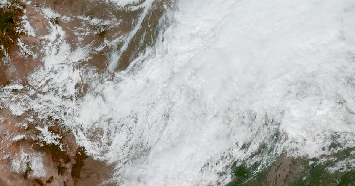
Key points
- As of Thursday evening, Freeze Warnings ran from Colorado's Front Range to North Dakota for the hours before dawn Friday, with lows forecast as cold as 25 in western North Dakota and 26 to 32 around Denver.
- A second cold night follows. Freeze Watches cover late Friday night into Saturday morning from the Texas South Plains through Kansas, Nebraska, Iowa, Minnesota and into southern Wisconsin and northern Illinois.
- The products warn of the same thing in near-identical words: frost and freeze conditions could kill crops and other sensitive plants, and could damage unprotected outdoor plumbing.
Tonight, officially
The wind made most of Thursday's headlines across the West, but by evening the longer list on the Weather Service's board was about cold. Behind the wind, colder air settles over the Plains, and forecast offices from Denver to Grand Forks put out Freeze Warnings for the early hours of Friday.
In Denver, the warning issued at 9:50 a.m. MDT covers the Front Range Urban Corridor and all of the eastern plains, from midnight to 9 a.m. MDT Friday. The office expects 26 to 32 degrees, coldest out on the plains. Farther north, NWS Bismarck issued its warning at 7:19 p.m. CDT for western and much of central North Dakota, including the Minot area, with lows as cold as 25 from 1 a.m. to 8 a.m. CDT Friday. The same product carried a Wind Advisory until midnight CDT for northwest gusts up to 55 mph. NWS Grand Forks added Benson, Cavalier, Ramsey, Towner and western Walsh counties, at 29 degrees from 1 to 9 a.m. CDT.
| Office | Product | Issued | In effect | Lowest temperature named |
|---|---|---|---|---|
| Denver CO | Freeze Warning | 9:50 a.m. MDT Thu | midnight to 9 a.m. MDT Fri | 26 to 32 |
| Bismarck ND | Freeze Warning (with Wind Advisory, gusts to 55 mph) | 7:19 p.m. CDT Thu | 1 to 8 a.m. CDT Fri | 25 |
| Grand Forks ND | Freeze Warning (with Wind Advisory, gusts to 45 mph) | 2:19 p.m. CDT Thu | 1 to 9 a.m. CDT Fri | 29 |
*Source: NWS alerts at api.weather.gov, read at 00:39 UTC on October 16. At that hour the alert feed held 17 Freeze Warnings from 12 offices and 33 Freeze Watches from 21 offices. The table lists the offices quoted here.*
Friday night, the watches
The second night reaches much farther south and east. On Thursday afternoon and evening, office after office posted a Freeze Watch for "late Friday night through Saturday morning". A watch means the freeze is possible and the office is still deciding.
On the Texas South Plains, NWS Lubbock's watch covers 13 counties, including Lubbock County. It says lows could reach 28 in the far southwestern Panhandle and 32 near the edge of the Caprock. NWS Amarillo covers the Oklahoma and Texas Panhandles at 26, and NWS Norman added Ellis and Harper counties in western Oklahoma at 30. In Kansas, the Wichita office named Saline County and four of its neighbors at 30.
The Midwest piece is the biggest. NWS Des Moines says "much of Iowa," including Polk County, could reach 30. Omaha's watch runs from Douglas and Lancaster counties in Nebraska across southwest Iowa. Sioux Falls covers southeast South Dakota and its neighbors in Iowa, Minnesota and Nebraska. The Twin Cities office lists Hennepin and Ramsey counties among dozens across Minnesota and western Wisconsin. Milwaukee covers Dane, Waukesha and south central Wisconsin at 27, the coldest figure east of the Panhandles. Chicago named Winnebago, Boone and Ogle counties in northern Illinois at 30. Kansas City's watch covers northwest and north central Missouri, from Atchison County to Sullivan County, plus a corner of northeast Kansas.
If you live under one of these and still have tomatoes or potted plants outside, the offices are telling you this is the weekend to deal with them.
| Office | Area named | Lowest temperature named | Ends |
|---|---|---|---|
| Lubbock TX | 13 South Plains counties incl. Lubbock | 28 to 32 | 10 a.m. CDT Sat |
| Amarillo TX | Oklahoma and Texas Panhandles | 26 (28 in Cimarron, Dallam, Hartley) | 9 a.m. CDT Sat |
| Norman OK | Ellis, Harper | 30 | 9 a.m. CDT Sat |
| Wichita KS | Barton, Ellsworth, Lincoln, Russell, Saline | 30 | 9 a.m. CDT Sat |
| Kansas City MO | northwest and north central Missouri, northeast Kansas | 30 | 9 a.m. CDT Sat |
| Omaha NE | east Nebraska, southwest Iowa | 30 | 8 a.m. CDT Sat |
| Sioux Falls SD | southeast South Dakota, northwest Iowa, southwest Minnesota, northeast Nebraska | 30 | 8 a.m. CDT Sat |
| Des Moines IA | much of Iowa | 30 | 9 a.m. CDT Sat |
| Twin Cities MN | central and southern Minnesota, west Wisconsin | not stated | 9 a.m. CDT Sat |
| Milwaukee WI | south central and southeast Wisconsin | 27 | 9 a.m. CDT Sat |
| Chicago IL | Winnebago, Boone, Ogle | 30 | 9 a.m. CDT Sat |
*Source: NWS Freeze Watch products, issued 12:37 p.m. to 7:26 p.m. CDT on Thursday, October 15, read from api.weather.gov. Each office's watch says "From late Friday night through Saturday morning."*
This is a morning summary, not emergency information. For live warnings see weather.gov and your local officials.
The rock's live forecast for the places in this story
More from the Journal
 THE WEATHER BEAT
Flash flood warnings covered Charleston, Parkersburg and Clarksburg, West Virginia, on Wednesday evening
OCT 14
THE WEATHER BEAT
Flash flood warnings covered Charleston, Parkersburg and Clarksburg, West Virginia, on Wednesday evening
OCT 14
 THE WEATHER BEAT
Kansas and Missouri under Flood Watches from four offices tonight, with a Slight Risk of severe storms along a stalled front
OCT 13
THE WEATHER BEAT
Kansas and Missouri under Flood Watches from four offices tonight, with a Slight Risk of severe storms along a stalled front
OCT 13
 EXPLAINERS
Why Is the Sky Blue?
AUG 20
EXPLAINERS
Why Is the Sky Blue?
AUG 20
Follow the Journal: RSS · get it by email