THE WEATHER BEAT · OCT 3
Nolo is a major hurricane again, ten days after Hawaii, with a Tropical Storm Warning over Papahanaumokuakea
Nolo regained Category 3 strength Saturday, 175 miles from Maro Reef, with a Tropical Storm Warning from Maro Reef to Lisianski Island.

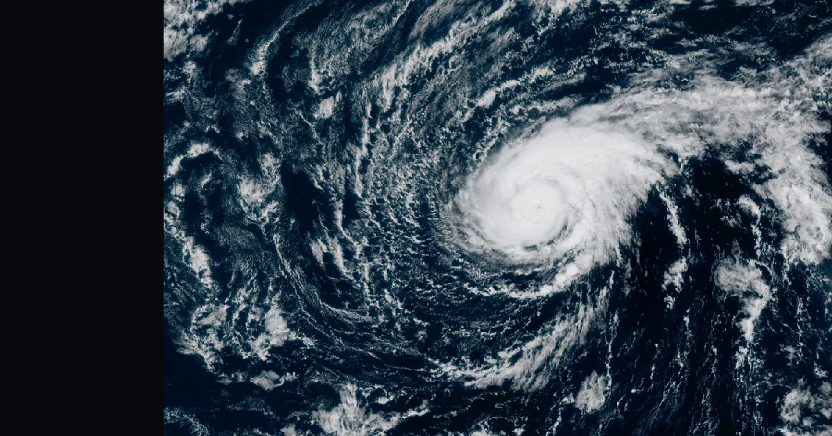
Key points
- As of the 8 a.m. HST advisory, Hurricane Nolo is a major hurricane again: Category 3, 115 mph winds, 959 mb, about 175 miles south-southwest of Maro Reef.
- A Tropical Storm Warning covers the Papahanaumokuakea Marine National Monument from Maro Reef to Lisianski Island. The advisory says the surf will likely flood some of the low-lying atolls there.
- The forecast keeps Nolo moving west, just south of the Northwestern Hawaiian Islands, and has it crossing the International Date Line by Sunday midday, Hawaii time.
Nolo has been in the news for a while. This desk followed it as it passed the Big Island on September 24 and 25, when the main islands had their watches and warnings. Ten days and fifty-two advisories later, Nolo is still going, and on Saturday morning it strengthened again, this time far out along the island chain.
The Central Pacific Hurricane Center's 5 a.m. HST advisory said Nolo would become a major hurricane later in the day. Three hours later, the 8 a.m. intermediate advisory said it had. Winds were up to 115 mph, which makes Nolo a Category 3 on the Saffir-Simpson scale. Pressure had fallen from 963 to 959 mb. The storm is moving faster too: due west at 16 mph, up from 14.
No town is under this warning. The land in its path is the Papahanaumokuakea Marine National Monument, a string of reefs and low atolls northwest of Kauai. From Maro Reef to Lisianski Island it is under a Tropical Storm Warning. Overnight the 5 a.m. advisory dropped the warning for the part of the monument east of Maro Reef, because the storm had moved past it. According to the advisory, the larger danger out there is the water. Large waves will keep reaching the monument for several days, and the surf will likely wash over some of the low-lying atolls between Maro Reef and Lisianski Island.
The advisory also says what comes next. Nolo should keep heading west and pick up speed. It should stay just south of the Northwestern Hawaiian Islands west of Maro Reef and cross the Date Line by Sunday midday, Hawaii time. Before it weakens on Monday it may strengthen a little more over the next day. Places in the monument west of Lisianski Island are asked to watch its progress.
| Hurricane Nolo (EP152026) | 5 a.m. HST, adv. 52 | 8 a.m. HST, adv. 52A |
|---|---|---|
| Position | 23.1N 171.2W | 23.2N 172.0W |
| Distance | 160 mi SSW of Maro Reef | 175 mi SSW of Maro Reef, 235 mi SSE of Lisianski Island |
| Max sustained wind | 110 mph | 115 mph (Category 3) |
| Pressure | 963 mb | 959 mb |
| Movement | W (265) at 14 mph | W (270) at 16 mph |
| Hurricane-force winds | out to 30 mi | |
| Tropical-storm-force winds | out to 150 mi | |
| Warning in effect | Tropical Storm Warning, Maro Reef to Lisianski Island | unchanged |
| Next advisory | 11 a.m. HST |
*Source: NWS Central Pacific Hurricane Center, Hurricane Nolo Advisory 52 (issued 5:00 a.m. HST Sat Oct 3, 2026) and Intermediate Advisory 52A (8:00 a.m. HST Sat Oct 3, 2026), read through the NWS products API. Hawaii Standard Time is UTC minus 10.*
The rest of the Pacific has two more items. In the eastern Pacific, Hurricane Rachel had 75 knots on the National Hurricane Center's 15:00 UTC advisory, at 19.6N 112.1W, moving west-northwest at 3 knots. No US watch or warning is attached to it. In the Marianas, the NWS office at Tiyan has a Flood Watch, High Surf Advisories and Wind Advisories in effect for Guam, Rota, Tinian and Saipan as of Saturday evening, Chamorro Standard Time.
This is a morning summary, not emergency information. For live warnings see weather.gov and your local officials. The Central Pacific Hurricane Center's products are at https://www.nhc.noaa.gov/?cpac and NWS Honolulu is at https://www.weather.gov/hfo/.
More from the Journal


Follow the Journal: RSS · get it by email