THE WEATHER BEAT · SEP 16
Iowa ran out of room for the rain, and canyon country had its own flood evening
Adair County reported closed roads on 2 to 4 inches of rain Tuesday evening, while 14 flash flood warnings ran from Utah slot canyons to the Texas South.

Key points
- Emergency management in Adair County, Iowa reported numerous closed roads on Tuesday evening after 2 to 4 inches of rain, with a flood warning running to Wednesday afternoon and Interstate 80 named in the product.
- As of the 8:12 p.m. CDT Tuesday flood watch, heavy rain was expected to expand across southern into central Iowa overnight into Wednesday morning, onto soils the Des Moines office measured at 50 to 90 percent of saturation in its southernmost counties.
- Fourteen flash flood warnings were in force across six Weather Service offices on Tuesday evening, from slot canyons in Utah's San Rafael Swell to the Frijoles burn scar in New Mexico and the Texas South Plains.
Yesterday: the water got ahead of Iowa
Iowa has had this rain before. That is the part that matters.
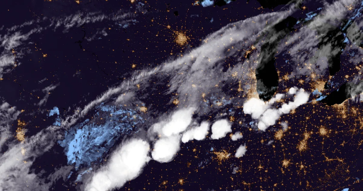
Tuesday afternoon and evening, September 15, the Weather Service office in Des Moines was not writing about a storm so much as about ground that had run out of room. By 8:07 p.m. CDT, Adair County emergency management had told the office that numerous roads in the county were closed and that water was coming up on Highway 25 south of Greenfield. Between 2 and 4 inches of rain had fallen. The warning the office put out three minutes later named the Middle River, listed Greenfield, Stuart, Adair, Fontanelle, Orient and Bridgewater, and included Interstate 80 between mile markers 73 and 96. Not a radar estimate. People on the ground, reporting closed roads.
Twenty five miles of interstate is a plain way to say how wide a small stream flood can reach in farm country, where the road and the creek have to share the same low spot.
The rivers were doing the slower version of the same thing. At 1:32 p.m. CDT the Raccoon River at the Fleur Drive gauge in Des Moines stood at 12.0 feet and rising, with minor flooding forecast and 13.5 feet the level at which water starts into the low parts of Water Works Park. West of there, the East Nishnabotna at Red Oak read 17.6 feet at 4 p.m. CDT against a bankfull stage of 18.0, and the Omaha office had it cresting at 19.7 feet just after midnight.
In its 6:39 p.m. CDT discussion the Des Moines office described a state cut in three: dry with some sun in the north, warm and humid with some sun in the far southeast, and "off and on showers" in between. The office wrote that many rivers and streams south of Highway 30 had risen, mostly within their banks, "but a few locations have reached or exceeded minor flood stage." It had already trimmed the flood watch off its northern counties twice in one day, once in the morning and again that afternoon, because the problem was moving south.
Iowa, for the nerds
| gauge or county | reading | time | product line |
|---|---|---|---|
| Adair County IA | 2 to 4 in fallen, numerous roads closed | 8:07 p.m. CDT Sep 15 | Flood Warning, NWS Des Moines, to 3:30 p.m. CDT Sep 16 |
| Raccoon River at Des Moines Fleur Dr | 12.0 ft, rising | 1:32 p.m. CDT Sep 15 | Flood Warning, NWS Des Moines, minor flooding |
| East Nishnabotna at Red Oak IA | 17.6 ft, bankfull 18.0 ft | 4:00 p.m. CDT Sep 15 | Flood Warning, NWS Omaha/Valley, crest 19.7 ft forecast |
Source: NWS active alerts and the KDMX Area Forecast Discussion issued 6:39 p.m. CDT September 15, 2026, read at 1:31 a.m. UTC September 16. Gauge stages are the values the products state.
Yesterday: canyon country had its own kind of day
The other half of the country's water was in places that hold none of it.
Tuesday evening in the interior West, eleven flash flood warnings were out at once across Utah, Arizona, Colorado and New Mexico, and the wording in them was the wording offices reserve for terrain that turns rain into a moving wall. At 7:09 p.m. MDT the Salt Lake City office extended a warning for south central Emery County, Utah for another half inch to inch of rain over the San Rafael Swell, and it listed the drainages by name: Muddy Creek, Ramp, Cistern, Ding, Dang, Bell, Little Wildhorse, Crack and Chute Canyons. The office called it "another flood wave moving through these drainages." An earlier warning that evening covered Iron Wash, Ernie Canyon and Eardley Canyon on half an inch of rain, which tells you most of what you need to know about how slot canyons work.
In Arizona, the report came from a person rather than a radar beam. At 5:48 p.m. MST the Flagstaff office wrote that the public had reported flash flooding across Gila and Navajo counties, including on Fort Apache Road, with up to 3 inches of rain fallen. The towns listed were Fort Apache, Whiteriver, Canyon Day, Turkey Creek, Seven Mile and East Fork. Twenty one minutes later the same office had a separate warning for Apache County with 1.5 to 3 inches already down.
New Mexico had the case that needs no rain at all to be a problem. At 6:43 p.m. MDT the Albuquerque office extended a warning for the Frijoles burn scar in southeastern Rio Arriba and northeastern Santa Fe counties on 1 to 1.75 inches of rain, naming Chimayo and Cundiyo. Burned ground sheds water like pavement. An inch there is not an inch somewhere else.
And on the Texas South Plains, three counties were under flash flood warnings on real measurements rather than estimates. The Lubbock office had radar and automated rain gauges putting 2 to 4 inches over Hale and Lubbock counties by 7:48 p.m. CDT, with the 7:48 product stating flatly that "flash flooding is already occurring." A fourth warning followed for Lamb County at 8:01 p.m. CDT on up to 3 inches.
The flash flood warnings, for the nerds
| county | office | rain stated | issued | expires |
|---|---|---|---|---|
| S central Emery, UT | Salt Lake City UT | add'l 0.5 to 1.0 in expected | 7:09 p.m. MDT | 9:00 p.m. MDT |
| Emery, UT | Salt Lake City UT | about 0.5 in fallen | 6:31 p.m. MDT | 8:00 p.m. MDT |
| Grand, UT (east central) | Grand Junction CO | 0.5 to 1 in, rate 1 to 3 in/hr | 5:51 p.m. MDT | 8:45 p.m. MDT |
| Grand, UT (west central) | Grand Junction CO | 0.5 to 1 in, rate 1 to 3 in/hr | 5:31 p.m. MDT | 8:30 p.m. MDT |
| Mesa, CO (northwest) | Grand Junction CO | 0.5 to 1 in, rate 1 to 3 in/hr | 6:25 p.m. MDT | 9:30 p.m. MDT |
| Apache, AZ | Flagstaff AZ | 1.5 to 3 in fallen | 6:09 p.m. MST | 9:15 p.m. MST |
| Gila and Navajo, AZ | Flagstaff AZ | up to 3 in fallen, public reported | 5:48 p.m. MST | 8:00 p.m. MST |
| Rio Arriba and Santa Fe, NM | Albuquerque NM | 1 to 1.75 in, Frijoles burn scar | 6:43 p.m. MDT | 7:45 p.m. MDT |
| Sandoval, NM | Albuquerque NM | 1.75 to 2.75 in fallen, rain ended | 6:19 p.m. MDT | 8:00 p.m. MDT |
| Otero, NM (west central) | El Paso TX/Santa Teresa NM | 1 to 2 in fallen | 6:18 p.m. MDT | 9:15 p.m. MDT |
| Luna, NM (southwest) | El Paso TX/Santa Teresa NM | 1 to 2 in fallen | 5:15 p.m. MDT | 8:15 p.m. MDT |
| Lubbock, TX | Lubbock TX | 2 to 4 in fallen | 7:45 p.m. CDT | 9:00 p.m. CDT |
| Hale, TX | Lubbock TX | 2 to 4 in fallen | 7:48 p.m. CDT | 8:45 p.m. CDT |
| Lamb, TX | Lubbock TX | up to 3 in fallen | 8:01 p.m. CDT | 9:30 p.m. CDT |
Source: NWS active alerts read at 1:31 a.m. UTC September 16, 2026. Rainfall figures are the amounts each product states, from radar, automated gauges or public report as each product says. Times are local to each warning.
Today, officially
The expectation, as of the products on the wire at 1:31 a.m. UTC Wednesday:
The Des Moines flood watch, issued 8:12 p.m. CDT Tuesday and running through Wednesday afternoon, covers 19 counties in central and southern Iowa and says heavy rainfall "expands across southern into central Iowa overnight through Wednesday morning." The Omaha office's watch, issued 3:09 p.m. CDT Tuesday for five southwest Iowa and ten southeast Nebraska counties, runs the same length. Two watches from the Topeka office, issued 6:52 p.m. CDT, cover 20 northeast Kansas counties until 5 a.m. CDT, and two from Kansas City, issued 2:42 p.m. CDT, cover 19 counties in northwest Missouri and the metro until 4:15 a.m. CDT.
The reason those watches exist is in the Des Moines discussion, and it is soil rather than sky. The office cited precipitable water values "around or above 2 inches," unseasonably high, with deep warm cloud depths for efficient rainfall, and National Water Model soil moisture at 50 to 90 percent of saturation in Iowa's bottom row of counties and generally above 80 percent north of that. Its phrase was "limited capacity."
Where the heaviest rain actually lands is a genuine disagreement between the models, and the office said so. Deterministic guidance put 2 to 5 inches over northern Missouri. The 12Z NAM and ECMWF put amounts like that over far southern Iowa instead. The 12Z HREF pushed the highest totals into Missouri, while the REFS ensemble kept a southern tier of Iowa counties in 2 to 4 inches. That is four ways of drawing the same rain, and the office left its watch where it was rather than pick one.
Looking past Wednesday, the office expects showers to go spotty and diminish through Wednesday afternoon and evening, then increase again after midnight into Thursday morning with 1 to at most 2 inches, amounts it described as not concerning except that they would fall on ground with no time to recover.
In the West, the flood watches ran to Wednesday morning: Grand Junction through 9:15 a.m. MDT for the San Juan Mountains, southeast Utah and the Canyonlands, plus a separate flash flood watch for the Central Yampa River Basin to 3 a.m. MDT; Salt Lake City to 3 a.m. MDT for the San Rafael Swell, Capitol Reef, Zion and Glen Canyon; Flagstaff to 7 a.m. MST for the Kaibab Plateau and Grand Canyon Country; Phoenix to 3 a.m. MST; and Albuquerque and El Paso through midnight MDT.
Severe weather was the quiet item. The Storm Prediction Center's day one outlook carried Marginal as its highest category, with a couple of severe storms possible from the southern High Plains to the southern Great Lakes, and two severe thunderstorm warnings from a single office were the national total on the wire. In the eastern Pacific, Tropical Depression Fifteen-E had 25 knot winds on the 21:00 UTC September 15 advisory. There were no tropical watches or warnings on United States soil.
The national board, for the nerds
| product | count | offices |
|---|---|---|
| Flood Watch | 21 | 13 |
| Flood Advisory | 18 | 7 |
| Flash Flood Warning | 14 | 6 |
| Flood Warning | 5 | 3 |
| Flash Flood Watch | 1 | 1 |
| Heat Advisory | 17 | 13 |
| Severe Thunderstorm Warning | 2 | 1 |
| Red Flag Warning | 2 | 1 |
| All active alerts | 365 | 20 or more |
Also on the board: flood warnings on the Withlacoochee River at US 41 Dunnellon in Citrus, Levy and Marion counties, Florida and on Horse Creek near Arcadia at SR 72 in DeSoto County, both minor flooding forecast from the Tampa Bay office; and a Fairbanks office flood watch issued 2:21 p.m. AKDT Tuesday for Two Rivers, the Fairbanks metro area and the Upper Kuskokwim Valley, running to 4 p.m. AKDT Wednesday.
Source: NWS active alerts and the SPC day one outlook text, both read at 1:31 a.m. UTC September 16, 2026. The SPC outlook's own issue time did not come through to this desk, so it is not stated; the category and summary are quoted as read. The tropical depression line is the 21:00 UTC September 15 advisory as carried on the wire; no position or pressure was available, so none is given. Yesterday's preliminary storm reports and the WPC excessive rainfall outlook were both unavailable to this desk, each returning HTTP 403.
This is a morning summary, not emergency information. For live warnings see weather.gov and your local officials. Iowa stream observations and forecasts are at weather.gov/desmoines/water, the page the Des Moines flood watch itself points to.
---
The rock's live forecast for the places in this story
More from the Journal


Follow the Journal: RSS · get it by email