THE WEATHER BEAT · OCT 13
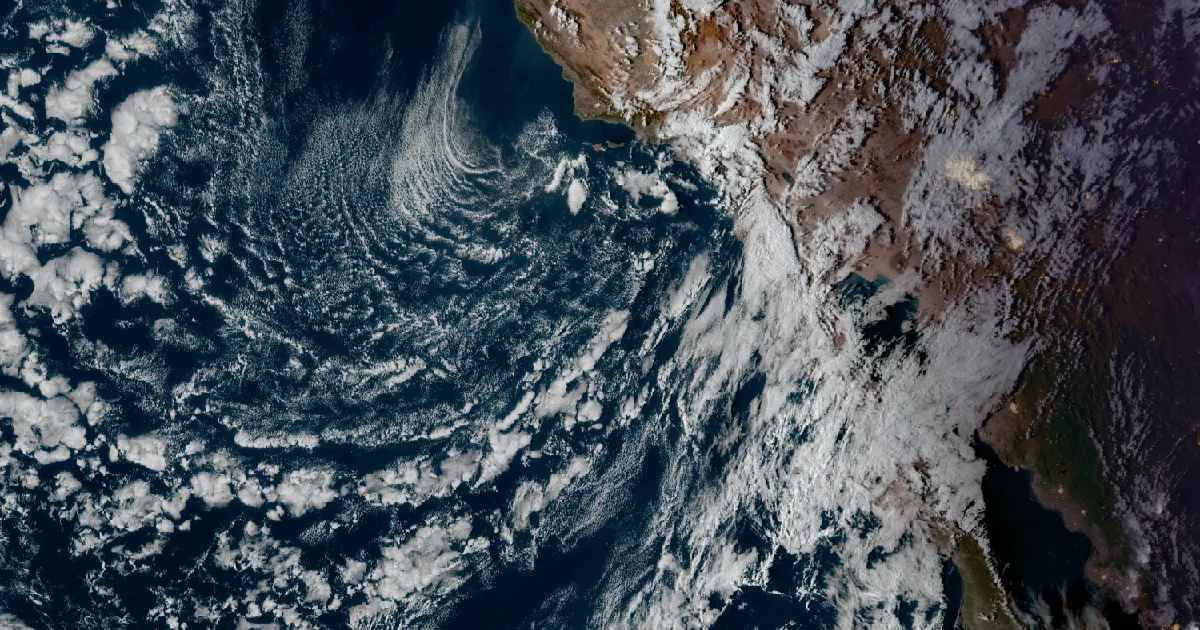
Santa Ana winds forecast for Thursday and Friday: High Wind and Fire Weather Watches from Los Angeles to San Diego, with coastal heat to 95
Los Angeles and San Diego forecasters posted High Wind Watches for gusts to 70 mph Thursday and Friday, and fire weather watches likely to become Red Flag.

Key points
- Two Southern California forecast offices issued High Wind Watches late Tuesday morning for a Santa Ana wind event on Thursday and Friday. They forecast gusts of 50 to 70 mph in the mountains and passes.
- NWS Los Angeles/Oxnard issued a Fire Weather Watch for Thursday and Friday. It wrote that it will likely upgrade the watch to Red Flag Warnings by Wednesday, with humidity falling to 5 to 15 percent by Friday.
- The offshore wind will also warm the coast. Heat Advisories run from Thursday through Saturday from San Luis Obispo County to San Diego County, with highs up to 95. High Wind Watches also cover Albuquerque and El Paso for Thursday night and Friday.
Today, officially
Southern California's weather turned on Tuesday. On Monday the region still had showers and high surf. Now the offices are planning for wind blowing the other way. NWS Los Angeles/Oxnard summed up the morning in its 11:10 a.m. PDT discussion: "We have increasing confidence in a strong Santa Ana Wind event peaking Thursday into Friday."
The same discussion explains how it works. High pressure over the Great Basin "forces winds up and over the mountains and down into the valleys and coastal areas." As the air sinks, it heats up. The office expects temperatures on the coast and in the valleys to rise by about 10 degrees each day. They should peak Friday, with highs in the upper 80s to mid 90s in most areas.
The watches came out within about ten minutes of each other. NWS San Diego sent its High Wind Watches at 11:11 a.m. PDT and Los Angeles/Oxnard sent its watches at 11:21 a.m. Both run from Thursday morning through Friday evening. San Diego's watch for its own county's mountains and inland valleys runs through Saturday evening, and the office says "Windiest period will be on Friday." The highest numbers are in the passes. San Diego wrote that gusts over 70 mph are possible through the San Gorgonio Pass near Banning. Los Angeles/Oxnard wrote gusts of 50 to 70 mph for the Santa Susana Mountains, the Interstate 5 Corridor and the San Gabriel Mountains. Both offices used the same impacts line: damaging winds could blow down trees and power lines, and power outages are possible.
The fire weather is the bigger concern. At 9:37 a.m. PDT Los Angeles/Oxnard opened its Fire Weather Watch with this headline: "HIGH RISK FOR EXTREME FIRE BEHAVIOR WITH ANY NEW FIRE STARTS THURSDAY THROUGH FRIDAY." The watch covers the Santa Monica Mountains, the Santa Clarita Valley, the San Fernando Valley, Calabasas and Agoura Hills, the Malibu Coast and most of Ventura County. The office says dry air "will settle over the region and dry out any helpful effects of the recent rains." It also says the watches "will likely be upgraded to Red Flag Warnings by Wednesday." NWS Hanford issued its own Fire Weather Watch at 9:50 a.m. PDT for the Tehachapi area and Fort Tejon. It put the chance of gusts over 40 mph at 30 to 50 percent on Thursday and 60 to 80 percent on Friday.
The heat products are separate from the wind products. Los Angeles/Oxnard's Heat Advisories cover the coast from San Luis Obispo County through Downtown Los Angeles and the Palos Verdes Hills, from 10 a.m. Thursday to 8 p.m. Saturday, with temperatures up to 95. San Diego's covers coastal and inland Orange County and coastal San Diego County, with the upper 80s to mid 90s and "Hottest temperatures expected on Friday."
The same pattern reaches inland. NWS Albuquerque issued a High Wind Watch at 12:05 p.m. MDT for east winds of 35 to 45 mph with gusts up to 65 mph. It covers the Albuquerque Metro Area and the Rio Grande Valley from Thursday evening through Friday morning. NWS El Paso issued one at 11:23 p.m. MDT... correction from the product: at 11:23 a.m. MDT, for gusts up to 65 mph in El Paso and Hudspeth counties and southern New Mexico, and it names a backdoor cold front arriving Thursday night. NWS Tucson's Wind Advisory runs from 11 p.m. Thursday to 11 a.m. Saturday, for gusts of 50 to 60 mph and possible blowing dust on the desert floor.
The numbers, by product
| Office, sent | Product | Area | Wind or heat | When |
|---|---|---|---|---|
| Los Angeles/Oxnard, 11:21 a.m. PDT | High Wind Watch | Santa Susana Mtns, I-5 Corridor, San Gabriel Mtns and Hwy 14, western Santa Monica Mtns | NE 25 to 45 mph, gusts 50 to 70 | Thu morning to Fri evening |
| Los Angeles/Oxnard, 11:21 a.m. PDT | Wind Advisory | San Fernando and Santa Clarita valleys, Calabasas, Agoura Hills, Ventura County valleys and mountains, Malibu Coast | NE 20 to 30 mph, gusts 35 to 55 | 6 a.m. Thu to 8 p.m. Fri |
| Los Angeles/Oxnard, 9:37 a.m. PDT | Fire Weather Watch | LA and Ventura County mountains, valleys and coast | NE 20 to 40 mph, gusts 50 to 70; RH 8 to 20 percent | Thu morning to Fri evening |
| Los Angeles/Oxnard, 11:21 a.m. PDT | Heat Advisory | SLO, Santa Barbara, Ventura and LA County coasts | up to 95 | 10 a.m. Thu to 8 p.m. Sat |
| San Diego, 11:11 a.m. PDT | High Wind Watch | San Gorgonio Pass, San Bernardino and Riverside County mtns | gusts up to 60, over 70 in the pass | Thu morning to Fri evening |
| San Diego, 11:11 a.m. PDT | High Wind Watch | Inland Empire | gusts up to 55, over 60 near foothills | Thu morning to Fri evening |
| San Diego, 11:11 a.m. PDT | High Wind Watch | San Diego County mountains and inland valleys | gusts up to 70 mtns, 60 valleys | Thu morning to Sat evening |
| San Diego, 11:11 a.m. PDT | High Wind Watch | Santa Ana Mountains and Foothills | gusts up to 60 | Thu morning to Fri evening |
| San Diego, 11:11 a.m. PDT | Heat Advisory | Orange County, coastal San Diego County | upper 80s to mid 90s | 10 a.m. Thu to 8 p.m. Sat |
| Hanford, 9:50 a.m. PDT | Fire Weather Watch | Tehachapi Area, Fort Tejon | 60 to 80 percent chance of gusts over 40 Fri; RH 15 to 25 percent | Thu morning to Fri evening |
| Albuquerque, 12:05 p.m. MDT | High Wind Watch | Albuquerque Metro, Rio Grande Valley, South Central Highlands | E 35 to 45 mph, gusts to 65 | Thu evening to Fri morning |
| El Paso, 11:23 a.m. MDT | High Wind Watch | El Paso and Hudspeth counties, NM Bootheel, Sacramento Mtns | NE 30 to 40 mph, gusts to 65 | Thu evening to Fri afternoon |
| Tucson, 2:16 a.m. MST | Wind Advisory | Tucson Metro, Nogales, south central Pinal County | E to SE 30 to 35 mph, gusts 50 to 60 | 11 p.m. Thu to 11 a.m. Sat |
Source: NWS alerts as read from api.weather.gov at 19:11Z on October 13, 2026, and the NWS Los Angeles/Oxnard (11:10 a.m. PDT, fire weather section 10:19 a.m.) and NWS San Diego (12:05 p.m. PDT) Area Forecast Discussions. All products are watches and advisories, and their wording can change with later issuances.
This is a summary of official warnings, not emergency information. For live warnings see weather.gov and your local officials. The Los Angeles/Oxnard office page is https://www.weather.gov/lox/ and the San Diego office page is https://www.weather.gov/sgx/.
The rock's live forecast for the places in this story
More from the Journal
 THE WEATHER BEAT
Isaias's remnants bring 3 to 7 inches of rain and Flash Flood Warnings to western North Carolina, from Lake Lure to Linville Falls
OCT 11
THE WEATHER BEAT
Isaias's remnants bring 3 to 7 inches of rain and Flash Flood Warnings to western North Carolina, from Lake Lure to Linville Falls
OCT 11
 THE WEATHER BEAT
Frost advisories from Puget Sound to Portland and freeze watches east of the Cascades: the first cold nights of fall, and the shirt for them
OCT 11
THE WEATHER BEAT
Frost advisories from Puget Sound to Portland and freeze watches east of the Cascades: the first cold nights of fall, and the shirt for them
OCT 11
 EXPLAINERS
Why Is the Sky Blue?
AUG 20
EXPLAINERS
Why Is the Sky Blue?
AUG 20
Follow the Journal: RSS · get it by email