THE WEATHER BEAT · SEP 8
Hurricane Lowell passes west of Kauai
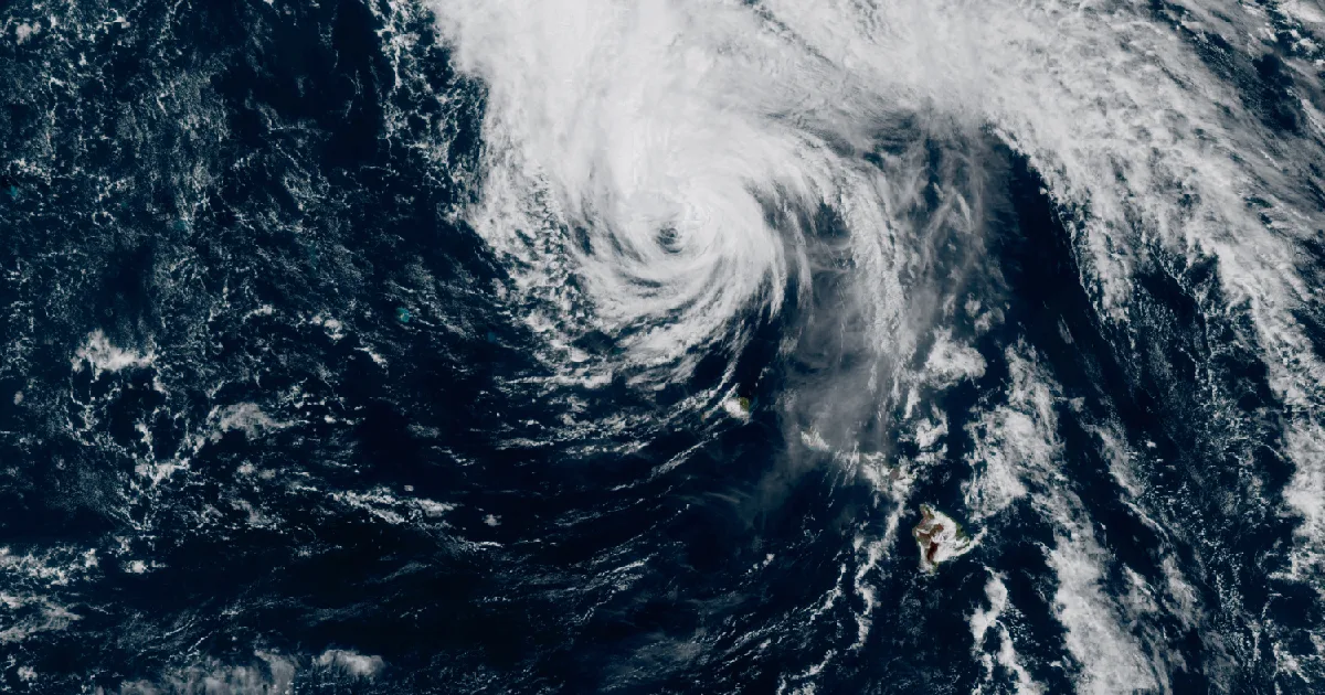
Hurricane Lowell passed 110 miles northwest of Lihue with 105 mph winds; Kauai gusted to 75 mph while hurricane warnings held into Tuesday morning.

Key points
- Hurricane Lowell passed about 110 miles northwest of Lihue overnight with 105 mph sustained winds. As of the 2 a.m. HST advisory, a Hurricane Warning covered Kauai and Niihau and a Tropical Storm Warning covered Oahu.
- Lihue Airport measured a 75 mph gust, a flash flood warning ran overnight on Kauai, and the advisory forecast another 4 to 8 inches of rain there, with storm totals near 24 inches possible.
- On the mainland, Monday brought three preliminary tornado reports in Louisiana, North Dakota, and Nebraska, and today's Storm Prediction Center outlook carries a Slight Risk for central Iowa and far eastern Nebraska, mainly for wind.
Yesterday: Lowell came to Kauai's door
The story of the day happened in the dark, in the middle of the Pacific. Hurricane Lowell spent Monday night closing on the western end of the Hawaiian island chain, and by 11 p.m. HST the National Weather Service office in Honolulu described it as a high-end category 2 about 90 miles west of Lihue. Tropical-storm-force winds were widespread across Kauai by then, and stations on the island's leeward side between Waimea and Barking Sands had already gusted above hurricane force. The core passed to the west of Niihau and Kauai overnight rather than over them, which is the difference between a hard night and a catastrophe.
Kauai still took a beating. Lihue Airport reported sustained winds of 53 mph with a gust to 75 mph near the time of the 2 a.m. HST advisory. Heavy rain sent streams up across the island, and a flash flood warning ran overnight; when Honolulu forecasters extended it at 1:17 a.m. HST, radar showed the rain had ended over Kauai but gauges showed nearly every stream on the island still elevated from runoff, with flooding impacts ongoing in many locations. On Oahu, Daniel K. Inouye International Airport in Honolulu reported a gust of 43 mph.
The mainland had its own Monday. A tornado was reported in Hammond, Louisiana at 2:39 p.m. CDT, where it damaged trees and clipped a school building along a track of about three quarters of a mile. A brief cone tornado was reported near Strawberry Lake, North Dakota at 6:35 p.m. CDT, and a storm chaser reported a third near Spencer, Nebraska at 7:35 p.m. CDT. Around those, a broad ribbon of wind damage stretched from Montana and the Dakotas down through Nebraska to the Gulf Coast parishes of Louisiana, with trees and power lines down from Slaughter to Thomasville.
Lowell, measured
| Reading (2 a.m. HST advisory 49A) | Value |
|---|---|
| Position | 22.9N 160.8W, about 110 mi NW of Lihue |
| Maximum sustained winds | 105 mph |
| Minimum central pressure | 965 mb |
| Movement | North at 18 mph |
| Hurricane-force winds extend | 70 mi from center |
| Tropical-storm-force winds extend | 195 mi from center |
| Lihue Airport (PHLI) | sustained 53 mph, gust 75 mph |
| Honolulu, Daniel K. Inouye Intl (PHNL) | gust 43 mph |
Source: CPHC/NHC Hurricane Lowell Intermediate Advisory 49A, issued 2:00 a.m. HST (1200 UTC) Tuesday, September 8, with position fixed by an Air Force Reserve Hurricane Hunter aircraft.
Mainland storm reports, September 7
| Type | Count | Notables |
|---|---|---|
| Tornado | 3 | Hammond LA (2:39 p.m. CDT), near Strawberry Lake ND (6:35 p.m. CDT), near Spencer NE (7:35 p.m. CDT) |
| Wind | 37 | 73 mph near Fort Pierre SD (9:20 a.m. CDT), 71 mph near Butte NE (6:10 p.m. CDT), 70 mph est. near Trenton NE (6:42 p.m. CDT), 68 mph Armour SD (11:15 p.m. CDT) |
| Hail | 3 | 1.75 in near Ruso ND (6:30 p.m. CDT), 1.25 in near Lake Andes SD (6:53 p.m. CDT) |
Source: Storm Prediction Center storm reports for the 12Z September 7 to 12Z September 8 day. All counts and values are preliminary.
Today, officially
Lowell first. As of the 2 a.m. HST advisory, the forecast took the core farther from Kauai County through today, then bent it northwest and west, slowing and weakening, after it clears the main islands. The rain is not done: the advisory forecast an additional 4 to 8 inches on Kauai with maximum storm totals of 24 inches possible, 3 to 8 more inches on the Big Island, and 2 to 5 more on Oahu and Maui County, with significant flash flooding and mudslides possible, especially on Kauai and parts of the Big Island. Storm surge of 2 to 4 feet was forecast for Kauai County, highest along Kauai's south coast and on Niihau, with up to 1 foot on Oahu. The advisory also said several tornadoes were possible near Kauai and Niihau through the overnight period, and that swells from Lowell would keep surf and rip currents life-threatening across many of the islands for the next few days. A statewide flood watch and high surf warnings were in effect overnight, and the 11:06 p.m. HST forecast discussion put it plainly: "High surf and heavy rain will impact all islands with strong winds mainly impacting the western end of the state." The same discussion noted the separate east-shore swell came from former Tropical Storm Karina, now a post-tropical low. The next complete Lowell advisory was scheduled for 5 a.m. HST. If you are in Hawaii, preparedness guidance lives at ready.gov and the Hawaii Emergency Management Agency.
On the mainland, the Storm Prediction Center's 1300 UTC Day 1 outlook, issued 7:31 a.m. CDT, carries a Slight Risk of severe thunderstorms over portions of central Iowa and far eastern Nebraska. The outlook expects widely scattered severe storms Tuesday afternoon and evening, mainly for damaging wind gusts, as a cold front works into a moderately to strongly unstable air mass, with more sporadic severe wind and large hail possible from the upper Midwest into the central Plains and a lower-end wind threat spreading into western Kansas in the evening.
Heat is still on the September map. Extreme heat warnings were in effect Tuesday morning from forecast offices in San Diego, Phoenix, and Las Vegas across the desert Southwest, and from Kansas City, Topeka, Springfield, and Tulsa across the southern Plains into western Missouri.
Out in the East Pacific, Tropical Storm Marie held 45 mph winds about 760 miles southwest of San Diego as of the 2 a.m. PDT advisory, moving west-northwest at 8 mph with no coastal watches or warnings in effect. The National Hurricane Center forecast steady weakening to a post-tropical remnant low later today or Wednesday, while its swell keeps beach conditions dangerous along the Baja California peninsula and Southern California for the next couple of days.
This is a morning summary, not emergency information. For live warnings see weather.gov and your local officials.
The rock's live forecast for the places in this story
More from the Weather Beat
More from the Journal
 THE WEATHER BEAT
Watch or warning? Interior Alaska's snowstorm splits: the mountains now under warnings, Fairbanks still on a watch
OCT 19
THE WEATHER BEAT
Watch or warning? Interior Alaska's snowstorm splits: the mountains now under warnings, Fairbanks still on a watch
OCT 19
 THE WEATHER BEAT
Nor'easter stalls off North Carolina: Hatteras and Ocracoke flood warnings now run to Wednesday, Hampton Roads under advisories
OCT 19
THE WEATHER BEAT
Nor'easter stalls off North Carolina: Hatteras and Ocracoke flood warnings now run to Wednesday, Hampton Roads under advisories
OCT 19
 EXPLAINERS
Why Is the Sky Blue?
AUG 20
EXPLAINERS
Why Is the Sky Blue?
AUG 20
Follow the Journal: RSS · get it by email