THE WEATHER BEAT · SEP 7
Hurricane Warning for Kauai and Niihau as Lowell makes its closest pass tonight
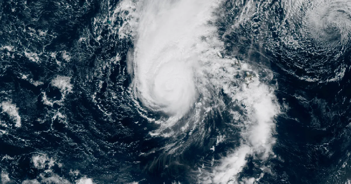
Kauai and Niihau are under a Hurricane Warning. Category 3 Lowell, 415 miles out at 2 a.m., passes just west of the islands tonight into Tuesday morning.

Key points
- Kauai and Niihau are under a Hurricane Warning as of 11 p.m. HST Sunday, upgraded from a tropical storm warning after Lowell's track shifted east again. At 2 a.m. HST Monday the category 3 hurricane was 415 miles southwest of Lihue HI with 115 mph winds, its rainbands already spreading over Kauai and Oahu, and its center is forecast to pass just west of Kauai County late today into early Tuesday.
- Sunday was quieter on the mainland: 141 preliminary wind reports, less than half of Saturday's count, but Montana ran a hail night with stones reported to 3 inches and windows broken out near Shepherd MT, and a storm chaser reported a brief tornado touchdown in western North Dakota, the first preliminary tornado report after two straight days without one.
- As of this morning's products: a Slight Risk of severe storms over North Dakota and southeast South Dakota into northeast Nebraska, mainly for large hail; Flood Watches across northwest and north central Montana through Tuesday morning; and Extreme Heat Warnings around Kansas City and Topeka running through Tuesday evening.
Yesterday
The Southeast's wind streak reached a fourth day, but it is finally shrinking. After Saturday's 340 reports, Sunday produced 141 nationwide, and the center of gravity stayed in South Carolina, which logged 50 of them, more than the next three states combined. The strongest was familiar ground: an NWS employee near Red Bank SC estimated gusts of 65 to 70 mph with small hail at 6:08 p.m. EDT, the same community where a trained spotter clocked 65 mph on Saturday. Georgia added 21 reports, and North Carolina, Saturday's leader with 138, fell to 9.
The bigger story was Montana, and it played out in two acts. The first came Sunday evening in the center of the state. Hail 3 inches in diameter was reported 5 miles north of Hilger MT at 9:25 p.m. MDT, confirmed with a photo from the public per the Great Falls office, with tennis ball hail estimated near Moccasin MT at 8:45 p.m. MDT and 2 inch hail at Danvers MT the same minute. The second act came after midnight near Billings: numerous public reports of hail around 2 inches at Shepherd MT at 2:30 a.m. MDT Monday, with windows broken out. Montana's 11 hail reports led the country.
The night storms carried wind too. A mesonet station 8 miles south of Sibley Peak WY measured 73 mph at 9:18 p.m. MDT, the day's strongest gust anywhere. The Rapid City SD airport measured 67 mph at 1:05 a.m. MDT Monday, and the Baker MT airport station matched it at 2:00 a.m. MDT.
And after two days without one, the country produced a single preliminary tornado report. A storm chaser reported a brief touchdown 8 miles south-southwest of Arnegard ND at 7:17 p.m. CDT Sunday, per the Bismarck office, which notes the location is radar estimated.
Largest measured gusts, September 6 into early September 7:
| Place | Gust (mph) | Local time |
|---|---|---|
| 8 S Sibley Peak WY | 73 | 9:18 p.m. MDT Sun |
| 3 W Red Bank SC | 70 (estimated) | 6:08 p.m. EDT Sun |
| Rapid City Airport SD | 67 | 1:05 a.m. MDT Mon |
| 1 SE Baker MT | 67 | 2:00 a.m. MDT Mon |
| 3 W Dumas TX | 66 | 2:55 p.m. CDT Sun |
| 5 WSW El Dorado Springs MO | 65 | 8:19 p.m. CDT Sun |
Largest hail:
| Place | Size (inches) | Local time |
|---|---|---|
| 5 N Hilger MT | 3.00 | 9:25 p.m. MDT Sun |
| 6 N Moccasin MT | 2.50 (estimated) | 8:45 p.m. MDT Sun |
| Danvers MT | 2.00 | 8:45 p.m. MDT Sun |
| Shepherd MT | 2.00 | 2:30 a.m. MDT Mon |
| 5 W Lexington SC | 2.00 | 5:47 p.m. EDT Sun |
Report counts for the day: 141 wind, 27 hail, 1 tornado. Wind reports by state: South Carolina 50, Georgia 21, Missouri 12, North Carolina 9, Florida 7, Mississippi 7, Kansas 6, Alabama 6, Arkansas 5, Montana 3, and 15 more spread across North Dakota, Louisiana, Colorado, Wyoming, South Dakota, Texas, Oklahoma, Iowa, Utah, and Minnesota. Hail reports: Montana 11, North Dakota 4, South Carolina 4, Kansas 3, Iowa 2, and one each in Minnesota, North Carolina, and Missouri.
Source: Storm Prediction Center preliminary storm reports for the 24 hours ending 8 a.m. EDT September 7. All counts, sizes, and gusts are preliminary and subject to revision.
Today, officially
Lowell and Hawaii
The warning got stronger overnight. Per Central Pacific Hurricane Center advisory 45, issued 11 p.m. HST Sunday, September 6, a Hurricane Warning is now in effect for Kauai County, including the islands of Kauai and Niihau, replacing the tropical storm warning that stood through the weekend. The accompanying discussion states the reason plainly: "Given another eastward shift in the track guidance and the forecast close approach of hurricane-force winds to Niihau, a Hurricane Warning has been issued for Kauai County." A Hurricane Warning also remains in effect for the Papahanaumokuakea Marine National Monument from Nihoa to French Frigate Shoals.
Per intermediate advisory 45A, issued 2 a.m. HST Monday, the center of Hurricane Lowell was about 415 miles southwest of Lihue HI and 445 miles southwest of Honolulu HI, with maximum sustained winds of 115 mph, a category 3, and a central pressure of 950 mb. Lowell was moving north-northeast at 10 mph, and rainbands from the storm were already spreading over Kauai and Oahu at advisory time. On the forecast track the center crosses portions of the marine monument, just west of the main Hawaiian Islands, tonight. Hurricane conditions are expected in Kauai County beginning this afternoon or evening, per the advisory, and the discussion's key message puts the pass "late Monday into early Tuesday." An Air Force Reserve Hurricane Hunter aircraft found the storm holding multiple concentric wind maxima around the eye overnight, with the central pressure slowly rising; gradual weakening is expected, but the forecast keeps Lowell a hurricane through its closest approach.
The rain arrived ahead of the wind. The Honolulu office reissued its Flood Watch for all Hawaiian islands at 3:12 a.m. HST Monday, running through 6 p.m. HST Tuesday, with the watch text noting that moisture along Lowell's eastern flank will bring periods of heavy rain through Tuesday. The advisory forecasts additional rainfall of 6 to 10 inches for Kauai with maximum totals of 14 inches possible, 4 to 8 inches for the Big Island with isolated totals of 12, 4 to 6 inches for Oahu with isolated 8, and 2 to 4 inches for Maui, rain that "may produce significant flash flooding and mudslides, especially across Kauai county and portions of the Big Island." Storm surge of 1 to 3 feet is possible in Kauai County and up to 1 foot on Oahu if the peak surge arrives at high tide. Several tornadoes are possible near Kauai and Niihau this afternoon through tonight, per the advisory, with a few possible across the remaining islands.
The surf is its own hazard. A High Surf Warning issued 2:44 p.m. HST Sunday covers south facing shores of all islands plus west facing shores of the Big Island through 6 a.m. HST Tuesday, and the Honolulu forecast discussion, issued 11:15 p.m. HST Sunday, expects the south swell from Lowell to rise rapidly today and peak tonight. The discussion adds a specific worry: "Coinciding also with the peak monthly afternoon high tides, this could bring the potential for significant damage to coastal properties and infrastructure, including roadways to portions of Kauai and possibly Oahu." On the water, a Hurricane Warning covers the offshore waters west of Kauai County and Tropical Storm Warnings cover the Kauai Channel and Kauai windward waters, per the same discussion, which also notes that any deviation in track in the next 24 hours would make a significant difference for the waters around Kauai County.
If you are in Kauai County, preparations should be rushed to completion, in the advisory's own words. Official preparedness guidance is at ready.gov, and the Hawaii Emergency Management Agency is at dod.hawaii.gov/hiema.
Advisory vitals, Lowell:
| Item | Value |
|---|---|
| Position (2 a.m. HST Mon) | 17.0N 163.0W |
| Distance | 415 mi SW of Lihue HI, 445 mi SW of Honolulu HI |
| Max sustained winds | 115 mph (category 3) |
| Central pressure | 950 mb |
| Movement | NNE at 10 mph |
| Hurricane-force wind extent | 60 miles from center |
| Tropical-storm-force extent | 175 miles from center |
| Warnings | Hurricane Warning: Kauai County (Kauai and Niihau) and the Papahanaumokuakea Marine National Monument, Nihoa to French Frigate Shoals |
| Next complete advisory | 5 a.m. HST Monday |
Source: CPHC Hurricane Lowell intermediate advisory 45A, issued 2 a.m. HST September 7; discussion 45, issued 11 p.m. HST September 6; NWS Honolulu forecast discussion, issued 11:15 p.m. HST September 6.
Severe storms, northern Plains
The Storm Prediction Center's Day 1 outlook, issued 7:44 a.m. CDT Monday, carries a Slight Risk over portions of North Dakota and from southeast South Dakota into northeast Nebraska. Its summary reads: "Widely scattered severe storms capable of mainly large hail are expected over portions of North Dakota as well as southeast South Dakota into northeast Nebraska this afternoon into evening." The setup is a deep upper trough over the western United States with a surface low over east central Montana, and the outlook notes that along one boundary near the North Dakota border, "any storms that develop should become supercells capable of all severe hazards, including very large hail and a brief tornado." A broader area of isolated hail and wind risk covers the northern and central Plains into the upper Mississippi Valley, with locally damaging gusts possible along the central Gulf Coast this afternoon and evening.
Montana rain
The same trough that hailed on Montana Sunday night is now a flood concern. The Weather Prediction Center's Day 1 excessive rainfall outlook, issued 4:15 a.m. EDT Monday, places a Slight Risk over northwest and north central Montana, and two forecast offices have Flood Watches running through noon MDT Tuesday: the Great Falls office, issued 6:01 a.m. MDT, for the East Glacier Park region, the Rocky Mountain Front, and the high plains east of the mountains, and the Missoula office, issued 3:59 a.m. MDT, for the West Glacier region, the Flathead and Mission valleys, and the Potomac and Seeley Lake region. Both watches say flooding caused by excessive rainfall continues to be possible, with excessive runoff able to flood creeks, streams, and low-lying areas.
Heat, middle of the country and Puerto Rico
Extreme Heat Warnings from the Kansas City office, issued 3:55 a.m. CDT, and the Topeka office, issued 2:13 a.m. CDT, run through Tuesday evening, September 8, for the Kansas City metro, west central Missouri, and much of east and northeast Kansas, with heat index values in excess of 105 per the Kansas City product and 100 to 107 per Topeka's. The Springfield MO office's warning, covering southwest Missouri and southeast Kansas with heat index up to 105, ends at 8 p.m. CDT tonight. In Puerto Rico, an Extreme Heat Warning issued 10:03 a.m. AST covers most of the island until 5 p.m. AST today. And the desert Southwest is next in line: the Phoenix office issued Extreme Heat Warnings at 12:33 a.m. MST Monday that begin Tuesday morning for the Phoenix metro, Yuma, and the lower Colorado River valley, with afternoon temperatures of 104 to 112 forecast into Thursday and Friday. None of the products states a covered population figure.
One reading from the other end of the thermometer: a Freeze Warning from the Medford OR office, issued Sunday morning, expired at 9 a.m. PDT this morning for the Klamath Basin and surrounding high country of southern Oregon and northeast California, including Klamath Falls OR, with lows as cold as 29 degrees. The same national map held a freeze warning and a 110 heat index at once. September does this.
Southeast Texas rivers
Two river warnings remain from Edouard's rain. Per the Lake Charles office's Flood Warning issued 8:11 p.m. CDT Sunday, Pine Island Bayou near Sour Lake TX, affecting Hardin and Jefferson counties, is warned until early Wednesday morning, and the Neches River at the saltwater barrier, affecting Hardin, Jefferson, Jasper, and Orange counties, until Wednesday night. The warning for Village Creek near Kountze TX was cancelled with the same product.
The rest of the tropics
Tropical Storm Marie, per NHC advisory 25 issued 2 a.m. PDT Monday, was about 580 miles west-southwest of Punta Eugenia, Mexico with 65 mph winds, weakening, and forecast to become a post-tropical remnant low Tuesday night or early Wednesday. The advisory headline notes the storm is expected to continue producing dangerous beach conditions along the coasts of Baja California and southern California for the next several days; there are no coastal watches or warnings. Former Tropical Storm Karina is now a post-tropical low northeast of Hawaii, per the Honolulu forecast discussion, and its leftover east swell is still contributing to a High Surf Advisory on east facing Hawaiian shores. The Atlantic has no active storms on the NHC board this morning.
This is a morning summary, not emergency information. For live warnings see weather.gov and your local officials.
The rock's live forecast for the places in this story
More from the Weather Beat
More from the Journal
 THE WEATHER BEAT
Watch or warning? Interior Alaska's snowstorm splits: the mountains now under warnings, Fairbanks still on a watch
OCT 19
THE WEATHER BEAT
Watch or warning? Interior Alaska's snowstorm splits: the mountains now under warnings, Fairbanks still on a watch
OCT 19
 THE WEATHER BEAT
Nor'easter stalls off North Carolina: Hatteras and Ocracoke flood warnings now run to Wednesday, Hampton Roads under advisories
OCT 19
THE WEATHER BEAT
Nor'easter stalls off North Carolina: Hatteras and Ocracoke flood warnings now run to Wednesday, Hampton Roads under advisories
OCT 19
 EXPLAINERS
Why Is the Sky Blue?
AUG 20
EXPLAINERS
Why Is the Sky Blue?
AUG 20
Follow the Journal: RSS · get it by email