THE WEATHER BEAT · SEP 5
Category 4 Lowell slows south of Hawaii ahead of its forecast turn
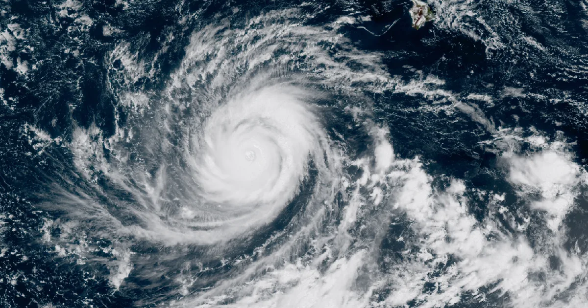
Category 4 Lowell is 610 miles from Honolulu; CPHC says watches could be required Saturday, with closest approach near Kauai forecast Monday night.

Key points
- As of the 11 p.m. HST advisory Friday, Hurricane Lowell was a category 4 with 155 mph winds about 610 miles south-southwest of Honolulu HI. No watches are in effect, but the Central Pacific Hurricane Center says watches could be required for the westernmost Hawaiian Islands on Saturday, and the Honolulu forecast office puts the closest approach near Kauai County Monday night.
- Friday was another wind day in the East, the second in a row: 173 preliminary wind reports nationwide, 66 of them in Virginia, and not a single tornado report anywhere in the country. The day's biggest measured gust, 81 mph, came from a separate storm near Aspermont TX.
- As of this morning's products: a Slight Risk of severe storms from the Ohio Valley into the Carolinas, Extreme Heat Warnings across six mid-Mississippi Valley states with the Kansas City and Topeka warnings running into Tuesday, and southeast Texas rivers still under flood warnings across six counties.
Yesterday
The front that spent Thursday dropping trees from Pennsylvania to Virginia kept working Friday, one tier of states farther south. The first calls came just after lunch in far western Maryland, where the Friendsville MD area logged about half a dozen reports of trees and wires down starting at 1:05 p.m. EDT on September 4. Through the afternoon the reports spread across southeast Ohio and West Virginia, a tree into a power line in Parkersburg WV at 1:30 p.m. EDT, and around 400 customers without power near Hamden OH.
Virginia took the evening shift, and took the most of it: 66 wind reports, the highest count of any state. Rockingham County lost trees onto power lines in Elkton VA and along McGaheysville Road, and in Lexington VA at 5:58 p.m. EDT, storm winds blew down six trees that landed on multiple power lines and three vehicles. Out on the coastal plain, a metal roof was blown off a house in Elizabeth City NC at 3:44 p.m. EDT. North Carolina's reports ran from mid-afternoon in the foothills near North Wilkesboro NC, where one downed tree fell on a vehicle with no injuries, to power outages in Nash and Edgecombe counties around 8:30 p.m. EDT.
The day never really closed. Before sunrise Saturday a new complex of storms was putting trees down across southeast Ohio and western West Virginia, with reports as late as 7:20 a.m. EDT, and 400 customers lost power near Elizabeth WV at 7 a.m. In Logan County OH, the Wilmington OH office's Flash Flood Warning, extended at 5:55 a.m. EDT Saturday, stated that local law enforcement had reported flash flooding after 3.5 to 4 inches of rain fell.
The Plains had their own, unrelated wind. The strongest measured gust in the country, 81 mph, hit 3 miles northeast of Aspermont TX at 4:59 p.m. CDT, with additional 70 to 72 mph gusts measured in the minutes before it. Overnight, a station near Guymon OK in the Oklahoma panhandle measured 77 mph at 12:50 a.m. CDT, and early Saturday morning gusts of 60 and 61 mph were measured in Holt County NE and near Dimock SD.
Hail was scarce and small. Seven reports all day, the largest a golf ball, 1.75 inches, 3 miles northwest of Parkersburg IA at 3:28 p.m. CDT, with ping pong ball hail in Madison and Orange counties in Virginia during the mid-afternoon.
Largest measured gusts, September 4 into early September 5:
| Place | Gust (mph) | Local time |
|---|---|---|
| 3 NE Aspermont TX | 81 | 4:59 p.m. CDT Fri |
| 1 WSW Guymon OK | 77 | 12:50 a.m. CDT Sat |
| 3 SE Dimock SD | 61 | 3:09 a.m. CDT Sat |
| 2 E Crewe VA | 60 | 5:55 p.m. EDT Fri |
| 8 NNE O'Neill NE | 60 | 5:19 a.m. CDT Sat |
| 3 ESE Boaz WV | 59 | 1:37 p.m. EDT Fri |
Report counts for the day: 173 wind, 7 hail, 0 tornado. Wind reports by state: Virginia 66, North Carolina 32, West Virginia 31, Ohio 23, Indiana 5, Maryland 4, Kentucky 3, Iowa 2, and one each in Alabama, Nebraska, Oklahoma, South Dakota, Tennessee, Texas, and Wisconsin. Hail reports: Virginia 4, Iowa 2, North Carolina 1.
Source: Storm Prediction Center preliminary storm reports for the 24 hours ending 8 a.m. EDT September 5. All counts and gusts are preliminary and subject to revision.
Today, officially
Hurricane Lowell and Hawaii
Lowell is the story of the weekend, and it is still days away. Per Central Pacific Hurricane Center advisory 37, issued 11 p.m. HST Friday, September 4, the eye of Hurricane Lowell was about 610 miles south-southwest of Honolulu HI and 625 miles south-southwest of Lihue HI, with maximum sustained winds of 155 mph measured by Air Force Hurricane Hunter aircraft and a central pressure of 925 mb. The advisory headline reads that Lowell "weakens slightly and is now a category 4 hurricane." It was moving west at 7 mph, and the advisory forecasts a gradual slowdown over the next day or so, followed by a sharp turn to the north or north-northeast on Sunday.
There are no coastal watches or warnings in effect. The advisory states that "watches could be required for portions of the westernmost Hawaiian Islands on Saturday."
The Honolulu forecast discussion, issued 8:20 p.m. HST Friday, reads: "Hurricane Lowell is forecast to move close to Kauai County Monday night as a category 2 to 3 hurricane. Weather impacts such as high surf and heavy rain are forecast to extend hundreds of miles from the center of Hurricane Lowell, potentially impacting any of the islands." The same discussion notes that "any deviation eastward from its forecast track could bring more severe wind impacts especially to Kauai County," and that as of Friday night it was "currently too early for tropical watches and warnings tonight, but will be discussed and determined soon."
The advisory's stated land hazards: rainfall totals of 3 to 6 inches for Kauai and the Big Island, with maximum totals exceeding 10 inches possible, 2 to 4 inches for Maui with isolated 8 inch totals possible, and 1 to 2 inches elsewhere, rain that "may produce flash flooding and mudslides, especially in areas of steep terrain." Swells are "likely to cause life-threatening surf and rip current conditions during the next several days across many of the Hawaiian islands."
If you are in Hawaii, this weekend is the time to check supplies and plans, not Monday. Official preparedness guidance is at ready.gov, and the Hawaii Emergency Management Agency is at dod.hawaii.gov/hiema.
Advisory vitals, Lowell:
| Item | Value |
|---|---|
| Position (11 p.m. HST Fri) | 13.3N 161.9W |
| Distance | 610 mi SSW of Honolulu HI, 625 mi SSW of Lihue HI |
| Max sustained winds | 155 mph (category 4) |
| Central pressure | 925 mb, by Hurricane Hunter aircraft |
| Movement | W at 7 mph |
| Hurricane-force wind extent | 60 miles from center |
| Tropical-storm-force extent | 160 miles from center |
| Watches or warnings | None in effect |
| Next complete advisory | 5 a.m. HST Saturday |
Source: CPHC Hurricane Lowell advisory 37 and NWS Honolulu forecast discussion, both issued the evening of September 4 HST.
Severe storms, Ohio Valley to the Carolinas
The Storm Prediction Center's Day 1 outlook, issued 7:54 a.m. CDT Saturday, carries a Slight Risk from portions of the Ohio Valley into the southern Mid-Atlantic and Carolinas. Its summary reads: "Severe thunderstorms capable of mainly damaging gusts are possible across portions of the Ohio Valley into southern Mid-Atlantic and Carolinas this afternoon and evening." The outlook tracks the same storm complex that was still producing tree damage in Ohio and West Virginia at daybreak, expecting it to continue southeastward across the central Appalachians into the Mid-Atlantic, with the highest chance of damaging gusts across eastern North Carolina. Isolated large hail and severe gusts are also possible over parts of the northern and central Plains today into tonight, per the same outlook.
The Raleigh forecast discussion, issued 8:07 a.m. EDT, leads with the other side of that coin: "Showers and thunderstorms and rain-cooled air this afternoon will provide localized relief from continued heat," with a Heat Advisory in effect for the southern Piedmont, Sandhills, and southern and central coastal plain.
The Weather Prediction Center's excessive rainfall outlook, issued 3:29 a.m. EDT, places a Slight Risk of rain exceeding flash flood guidance over central and eastern Virginia and the eastern Carolinas, the same corridor the storms are expected to work.
Heat in the middle of the country
Ten Extreme Heat Warnings from seven forecast offices cover parts of Missouri, Kansas, Illinois, Iowa, Indiana, and Kentucky this morning, including the St. Louis MO, Kansas City MO, and Topeka KS metros. The St. Louis product, issued 2:29 a.m. CDT, states heat index values up to 110; Paducah's, issued 12:39 a.m. CDT, states 105 to 110 for southern Illinois, southwest Indiana, western Kentucky, and southeast Missouri; Lincoln IL's, issued 6:08 a.m. CDT, states up to 106 for central Illinois. Most of the warnings end at 7 or 8 p.m. CDT this evening, but the heat is not done everywhere: the Kansas City warning for east central Kansas and western Missouri and the Topeka warning both run through Tuesday evening, September 8, and Springfield MO's warning, which cites "multiple consecutive days" of heat index values up to 110, runs through 8 p.m. CDT Sunday. None of the products states a covered population figure.
Southeast Texas rivers
The long tail of Edouard keeps shrinking. Menard Creek near Rye TX, which was in moderate flooding earlier this week, is now in minor flooding per the Houston/Galveston warning extended at 9:38 p.m. CDT Friday, with that warning running until early Saturday afternoon. The Lake Charles office's warning, issued 8:09 p.m. CDT Friday, continues for Village Creek near Kountze TX until Sunday morning, for Pine Island Bayou near Sour Lake TX until early Tuesday, and for the Neches River at the saltwater barrier until Wednesday night. Six counties remain covered: Hardin, Liberty, Polk, Jefferson, Jasper, and Orange.
River warning vitals:
| River and gauge | Status | Counties | Warning runs until |
|---|---|---|---|
| Menard Creek near Rye TX | Minor flooding occurring | Liberty, Hardin, Polk | Saturday afternoon (12:46 p.m. CDT Sep 5) |
| Village Creek near Kountze TX | Warning continues | Hardin | Sunday morning (10:36 a.m. CDT Sep 6) |
| Pine Island Bayou near Sour Lake TX | Warning extended | Jefferson, Hardin | Early Tuesday (3:24 a.m. CDT Sep 8) |
| Neches River at Saltwater Barrier | Warning continues | Jefferson, Hardin, Jasper, Orange | Wednesday night (10 p.m. CDT Sep 9) |
Source: NWS Houston/Galveston and Lake Charles Flood Warnings issued the evening of September 4.
The rest of the tropics
Two more hurricanes are up, both in the Pacific, both far from land, both weakening. Hurricane Karina, per CPHC advisory 36 issued 11 p.m. HST Friday, was about 825 miles east of Hilo HI with 75 mph winds, moving northwest at 8 mph and forecast to become post-tropical by Monday, no watches or warnings. Hurricane Marie, per NHC advisory 17 issued 2 a.m. PDT Saturday, was about 635 miles west of the southern tip of Baja California with 90 mph winds, moving northwest at 8 mph on a gradual weakening trend, no watches or warnings. The Atlantic has no active storms on the NHC board this morning.
Elsewhere
The Weather Prediction Center's Day 1 excessive rainfall outlook, issued 3:29 a.m. EDT and valid through Sunday morning, also carries Marginal Risk areas along the Gulf Coast from Texas to the Florida panhandle, over South Florida, across the Southwest into the southern High Plains and Nebraska, and over a patch of the upper Midwest. In New Mexico, a Flood Watch from the Albuquerque office, issued 9:10 p.m. MDT Friday, covers the South Central Mountains through 6 p.m. MDT this evening.
This is a morning summary, not emergency information. For live warnings see weather.gov and your local officials.
The rock's live forecast for the places in this story
More from the Weather Beat
More from the Journal
 THE WEATHER BEAT
Watch or warning? Interior Alaska's snowstorm splits: the mountains now under warnings, Fairbanks still on a watch
OCT 19
THE WEATHER BEAT
Watch or warning? Interior Alaska's snowstorm splits: the mountains now under warnings, Fairbanks still on a watch
OCT 19
 THE WEATHER BEAT
Nor'easter stalls off North Carolina: Hatteras and Ocracoke flood warnings now run to Wednesday, Hampton Roads under advisories
OCT 19
THE WEATHER BEAT
Nor'easter stalls off North Carolina: Hatteras and Ocracoke flood warnings now run to Wednesday, Hampton Roads under advisories
OCT 19
 EXPLAINERS
Why Is the Sky Blue?
AUG 20
EXPLAINERS
Why Is the Sky Blue?
AUG 20
Follow the Journal: RSS · get it by email