THE WEATHER BEAT · SEP 6
Tropical Storm Warning issued for Kauai and Niihau as Lowell begins its turn
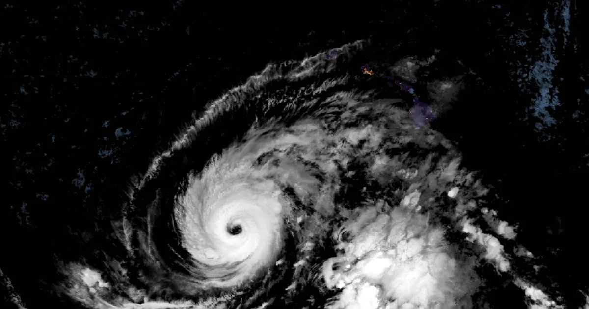
A Tropical Storm Warning covers Kauai and Niihau. Category 3 Lowell, 580 miles out, is forecast to pass 100 to 200 miles west of Kauai Monday night.

Key points
- A Tropical Storm Warning is in effect for Kauai and Niihau as of the 5 a.m. HST advisory Sunday. Hurricane Lowell, a category 3 with 125 mph winds about 580 miles south-southwest of Lihue HI, is forecast to pass 100 to 200 miles west of Kauai Monday night, and a Flood Watch covers every island from noon Sunday through Tuesday evening.
- Saturday was the busiest wind day of the stretch: 340 preliminary wind reports nationwide, nearly double Friday's 173, and again not one tornado report. The Carolinas took 232 of them, one person was injured by trees falling on homes near Rogersville TN, and a western Nebraska storm gusted to 83 mph at Kingsley Dam just after midnight.
- As of this morning's products: a Slight Risk of severe storms over the southern Appalachians into the Savannah River valley and another over western and central Montana, Kansas City and Topeka Extreme Heat Warnings running through Tuesday evening, and the southeast Texas river flood warnings now down to four counties.
Yesterday
For the third day in a row the East's afternoon storms put trees down, and for the third day the damage moved south. Thursday it was Pennsylvania to Virginia, Friday it was Virginia and the mountains, and Saturday the Carolinas took the most of it: 138 wind reports in North Carolina and 94 in South Carolina, the two highest state counts in the country.
The day's one reported injury came before the Carolinas even got going. At 11:50 a.m. EDT on September 5, storm winds near Rogersville TN dropped trees onto several homes between Rogersville and the community of Persia, injuring one person, per the Morristown office's report. Three hours later and one state over, photos from McMinnville TN showed the roof of one building peeled off and blown into the restaurant next door at 3:35 p.m. CDT.
Then the Piedmont's turn. Asheboro NC logged four separate tree-on-house reports in a seven minute span starting at 3:11 p.m. EDT, plus a tree and power lines down on a car with a person inside on Farmer Road, no injuries. At 3:35 p.m. EDT the Chatham County 911 center had at least two dozen reports of trees down in Siler City NC, a few of them on homes. The day's strongest East Coast gust, 72 mph, was measured at the Fayetteville airport east of Hope Mills NC at 4:48 p.m. EDT, and Pope Army Airfield measured 64 mph seven minutes later. In South Carolina a trained spotter near Red Bank SC clocked gusts of 55 to 65 mph between 5:40 and 5:45 p.m. EDT, a large tree came down on a house near Blacksburg SC at 3:05 p.m. EDT, and a porch lost its roof near Williamston SC. Georgia added 36 reports, including a large tree onto vehicles in Hall County at 5:15 p.m. EDT.
Hail stayed mostly small in the East: quarter to golf ball size at Fort Barnwell NC at 5:15 p.m. EDT, and 2 inch hail near Flowers in Johnston County at 4:15 p.m. EDT.
The Plains ran their own storm, and it lasted all night. Trained spotters around Alliance NE reported 2 to 2.5 inch hail starting at 4:01 p.m. MDT, with hail accumulating on the ground by early evening. The wind followed: 64 mph east of Bridgeport NE at 6:18 p.m. MDT, 66 mph at the Alliance airport station at 7:24 p.m., 65 mph at a personal weather station near Lorenzo at 9:22 p.m. Then, just after midnight, the storms crossing Keith County hit their peak: 76 mph at a station near Kingsley Dam at 11:57 p.m. MDT, 83 mph on a Union Pacific sensor northeast of the dam at 12:10 a.m. MDT Sunday, and 78 mph west of Paxton NE five minutes later.
Largest measured gusts, September 5 into early September 6:
| Place | Gust (mph) | Local time |
|---|---|---|
| 3 NNE Kingsley Dam NE | 83 | 12:10 a.m. MDT Sun |
| 7 W Paxton NE | 78 | 12:15 a.m. MDT Sun |
| 1 WSW Kingsley Dam NE | 76 | 11:57 p.m. MDT Sat |
| 4 ENE Hope Mills NC | 72 | 4:48 p.m. EDT Sat |
| 5 SE Alliance NE | 66 | 7:24 p.m. MDT Sat |
| 5 W Red Bank SC | 65 | 5:40 p.m. EDT Sat |
Report counts for the day: 340 wind, 31 hail, 0 tornado. Wind reports by state: North Carolina 138, South Carolina 94, Georgia 36, Nebraska 17, Virginia 14, Tennessee 12, Kentucky 7, West Virginia 5, Alabama 5, Missouri 4, Texas 2, and one each in Colorado, Florida, Illinois, Indiana, Louisiana, and New Mexico. Hail reports: North Carolina 12, Nebraska 12, North Dakota 3, and one each in Colorado, Kentucky, South Carolina, and South Dakota. Largest hail: 2.5 inches, 5 miles west-northwest of Alliance NE.
Source: Storm Prediction Center preliminary storm reports for the 24 hours ending 8 a.m. EDT September 6. All counts and gusts are preliminary and subject to revision.
Today, officially
Lowell and Hawaii
The waiting phase ended overnight. Per Central Pacific Hurricane Center advisory 42, issued 5 a.m. HST Sunday, September 6, a Tropical Storm Warning is now in effect for Kauai County, including the islands of Kauai and Niihau, and a Hurricane Warning is in effect for the Papahanaumokuakea Marine National Monument from Nihoa to French Frigate Shoals. At advisory time the center of Hurricane Lowell was about 580 miles south-southwest of Lihue HI and 600 miles southwest of Honolulu HI, with maximum sustained winds of 125 mph, a category 3, and a central pressure of 943 mb. Lowell was moving north-northwest at 6 mph, and the advisory forecasts "a turn toward the north and north-northeast with an increase in forward speed" over the next couple of days, "bringing the center of Lowell across portions of the Papahanaumokuakea Marine National Monument, just west of the main Hawaiian Islands, Monday night." The advisory expects Lowell to remain a major hurricane through Monday, with gradual weakening beginning tonight.
The Honolulu forecast discussion, issued 5:01 a.m. HST Sunday, puts the pass this way: "Lowell is forecast to pass 100 to 200 miles west of Kauai, and will bring several hazards to the state. The main hazards are expected to be flash flooding, strong winds, and high surf." One bookkeeping note: that discussion still refers to a Tropical Storm watch for Kauai and Niihau; the warning products issued ten minutes earlier and the 5 a.m. advisory both carry the warning, so the discussion's wording simply lags the upgrade.
The rain is not waiting for the storm. The same discussion reports that moisture "has already increased across the area more than forecast," with several windward areas picking up over 1.5 inches in six hours Sunday morning, and the office moved the start of its Flood Watch up from 6 p.m. to noon HST Sunday. The watch covers every island through 6 p.m. HST Tuesday. The advisory's rainfall forecast: 6 to 10 inches for Kauai with maximum totals of 14 inches possible, 4 to 8 inches for the Big Island with isolated totals of 12, 2 to 4 inches for Maui with isolated 8, and 2 to 4 inches elsewhere, rain that "may produce significant flash flooding and mudslides, especially across Kauai County and portions of the Big Island." Storm surge of 1 to 3 feet is possible in Kauai County and up to 1 foot on Oahu if the peak surge arrives at high tide, and swells are "likely to cause life-threatening surf and rip current conditions during the next several days across many of the Hawaiian islands." A High Surf Advisory issued 4:17 a.m. HST runs through 6 a.m. HST Tuesday. The discussion also flags a threat of short-lived tornadoes and waterspouts embedded in rainbands, mainly near Kauai and Niihau, as Lowell makes its closest approach Monday night into early Tuesday.
Tropical storm conditions are expected in Kauai County by Monday afternoon or evening, per the advisory. If you are in Hawaii, today is the day to finish preparations. Official preparedness guidance is at ready.gov, and the Hawaii Emergency Management Agency is at dod.hawaii.gov/hiema.
Advisory vitals, Lowell:
| Item | Value |
|---|---|
| Position (5 a.m. HST Sun) | 14.7N 163.8W |
| Distance | 580 mi SSW of Lihue HI, 600 mi SW of Honolulu HI |
| Max sustained winds | 125 mph (category 3) |
| Central pressure | 943 mb |
| Movement | NNW at 6 mph |
| Hurricane-force wind extent | 50 miles from center |
| Tropical-storm-force extent | 175 miles from center |
| Warnings | Tropical Storm Warning: Kauai County (Kauai and Niihau). Hurricane Warning: Papahanaumokuakea Marine National Monument, Nihoa to French Frigate Shoals |
| Next advisories | Intermediate 8 a.m. HST, complete 11 a.m. HST Sunday |
Source: CPHC Hurricane Lowell advisory 42 and NWS Honolulu forecast discussion, both issued 5 a.m. HST September 6.
Severe storms, Southeast and Montana
The Storm Prediction Center's Day 1 outlook, issued 7:51 a.m. CDT Sunday, carries two Slight Risk areas. Its summary reads: "Widely scattered damaging wind gusts are likely across portions of the Southeast this afternoon and early evening. Widely scattered large hail occurrences are expected across portions of western and central Montana this afternoon and evening." The Southeast area runs from the southern Appalachians into the Savannah River valley, the same general country that spent Saturday picking up tree damage; the outlook expects storms in a hot, moist airmass with weak shear, favoring gusty multicells and line segments over anything organized. The outlook also tracks the overnight Nebraska storm complex, noting "a linear MCS continues to push eastward across the central Plains this morning" with new development in south-central and southeast South Dakota and adjacent northeast Nebraska, and it holds isolated severe risk from the eastern Dakotas and western Minnesota into the Ozark Plateau and Gulf Coast states.
The Weather Prediction Center's Day 1 excessive rainfall outlook, issued 4:04 a.m. EDT, places Slight Risk areas over the western Carolinas and Georgia into north Florida, from southeast South Dakota and southwest Minnesota into western Iowa, eastern Nebraska, and northwest Missouri, and over the Great Basin from southern Nevada across southern Utah.
Heat around Kansas City
The mid-Mississippi Valley heat is on its last widespread day, but not everywhere. Extreme Heat Warnings from the Kansas City office, issued 3:39 a.m. CDT, and the Topeka office, issued 1:50 a.m. CDT, run through Tuesday evening, September 8, for the Kansas City metro and east-central Kansas, with heat index values in excess of 105 per the Kansas City product and 100 to 108 per Topeka's. Warnings covering the rest of west-central Missouri, the Springfield MO area (heat index up to 107), west-central Arkansas per the Tulsa office (up to 112), and Puerto Rico end this evening. None of the products states a covered population figure.
Southeast Texas rivers
The tail of Edouard is down to four counties. Per the Lake Charles office's Flood Warning issued 8:16 p.m. CDT Saturday, Village Creek near Kountze TX is warned until early Monday, Pine Island Bayou near Sour Lake TX until Monday night, and the Neches River at the saltwater barrier, covering Hardin, Jefferson, Jasper, and Orange counties, until early Wednesday.
The rest of the tropics
The other two storms are winding down far from land. Tropical Storm Karina, per CPHC advisory 41 issued 5 a.m. HST Sunday, was about 680 miles east-northeast of Hilo HI with 60 mph winds, forecast to become a post-tropical gale by late tonight. Hurricane Marie, per NHC advisory 22 issued 8 a.m. PDT Sunday, was about 800 miles west of the southern tip of Baja California with 80 mph winds, weakening, with the advisory headline noting dangerous beach conditions along the coasts of Baja California and southern California for another couple of days. Neither has watches or warnings. The Atlantic has no active storms on the NHC board this morning.
This is a morning summary, not emergency information. For live warnings see weather.gov and your local officials.
The rock's live forecast for the places in this story
More from the Weather Beat
More from the Journal
 THE WEATHER BEAT
Watch or warning? Interior Alaska's snowstorm splits: the mountains now under warnings, Fairbanks still on a watch
OCT 19
THE WEATHER BEAT
Watch or warning? Interior Alaska's snowstorm splits: the mountains now under warnings, Fairbanks still on a watch
OCT 19
 THE WEATHER BEAT
Nor'easter stalls off North Carolina: Hatteras and Ocracoke flood warnings now run to Wednesday, Hampton Roads under advisories
OCT 19
THE WEATHER BEAT
Nor'easter stalls off North Carolina: Hatteras and Ocracoke flood warnings now run to Wednesday, Hampton Roads under advisories
OCT 19
 EXPLAINERS
Why Is the Sky Blue?
AUG 20
EXPLAINERS
Why Is the Sky Blue?
AUG 20
Follow the Journal: RSS · get it by email