THE WEATHER BEAT · SEP 6
Why Saturday's Showers Crossed New England From North to South
On September 5 the showers over Connecticut moved north to south, the wrong way for this sky. The setup that did it, from NOAA analyses and our own radar.

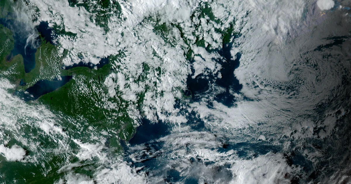
On the evening of September 5, the showers over Connecticut moved from north to south. For this part of the world that is the wrong direction. Most of the year our weather rides a wind from the west or southwest, so a storm that crosses the state usually arrives from Pennsylvania or the Hudson Valley and leaves toward Rhode Island and the ocean. On Saturday night the showers came down out of New Hampshire and Massachusetts, crossed Connecticut heading south-southeast, and continued toward Long Island. Someone who has watched this sky for decades told us he had never seen it. Here is what did it, from the National Weather Service's own analyses and discussions, and from our radar and wind data.
What happened, measured
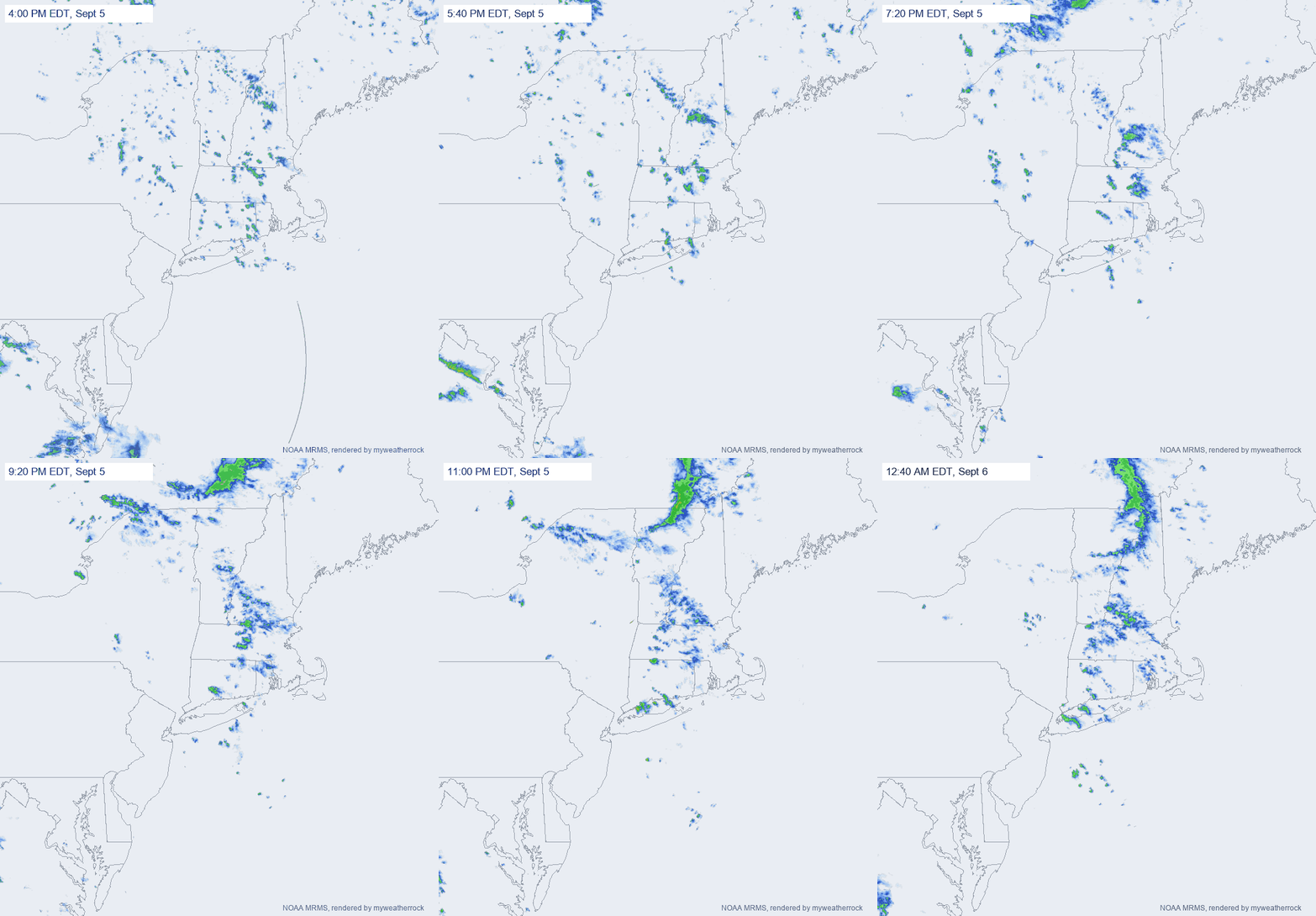
Our storm-motion tool reads consecutive radar frames and measures how the echoes shift. At 8 PM, over Oakville in Litchfield County, it measured the cells moving toward the south-southeast, 166 to 169 degrees on the compass, at 14 to 17 mph, frame after frame, with a confidence of about 0.7 on each pair. That is the number behind the impression: the rain was heading south.
The forecasters saw it coming. The New York office wrote at 8:04 PM that showers would develop "across eastern CT and eastern LI before tracking south and west tonight." The Boston office, at 7:49 PM, described "wrap-around moisture in northeast flow across much of New England."
The setup at 8 PM
Three things were in place at the same time, and each one pushed in the same direction.
A closed low aloft, parked to the northeast. The New York office's discussion put it plainly: "An upper low over the Canadian Maritimes will remain nearly stationary through Sunday, sending a series of shortwaves south across the Northeast." Boston called it "slow-moving, closed mid/upper low pressure over the Canada Maritimes" inside "a broad cyclonic mid-level flow." Air circles a low counterclockwise. On the western side of a low that sits over the Maritimes, that circulation runs from north to south, straight across New England. Storm cells travel with the wind a mile or two above the ground, so a cell born over New Hampshire went south.
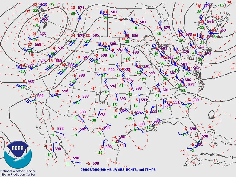
The Storm Prediction Center's 500 mb chart for that hour shows the flow directly: over New England the winds at roughly 18,000 feet are out of the north and northwest, and the heights run 573 to 579 decameters, low for early September. The low itself sits just off the chart to the northeast.
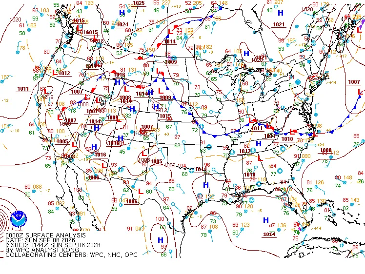
High pressure to the north and west, low pressure to the south and east. At the surface, the Weather Prediction Center's analysis for the same hour draws high pressure of 1020 to 1021 millibars over the Great Lakes and Quebec, and a cold front along the Mid-Atlantic coast with low pressure on it. Air moves from high pressure toward low, bent to the right in the northern hemisphere, and that gradient sets a surface wind from the north and northeast over the region.
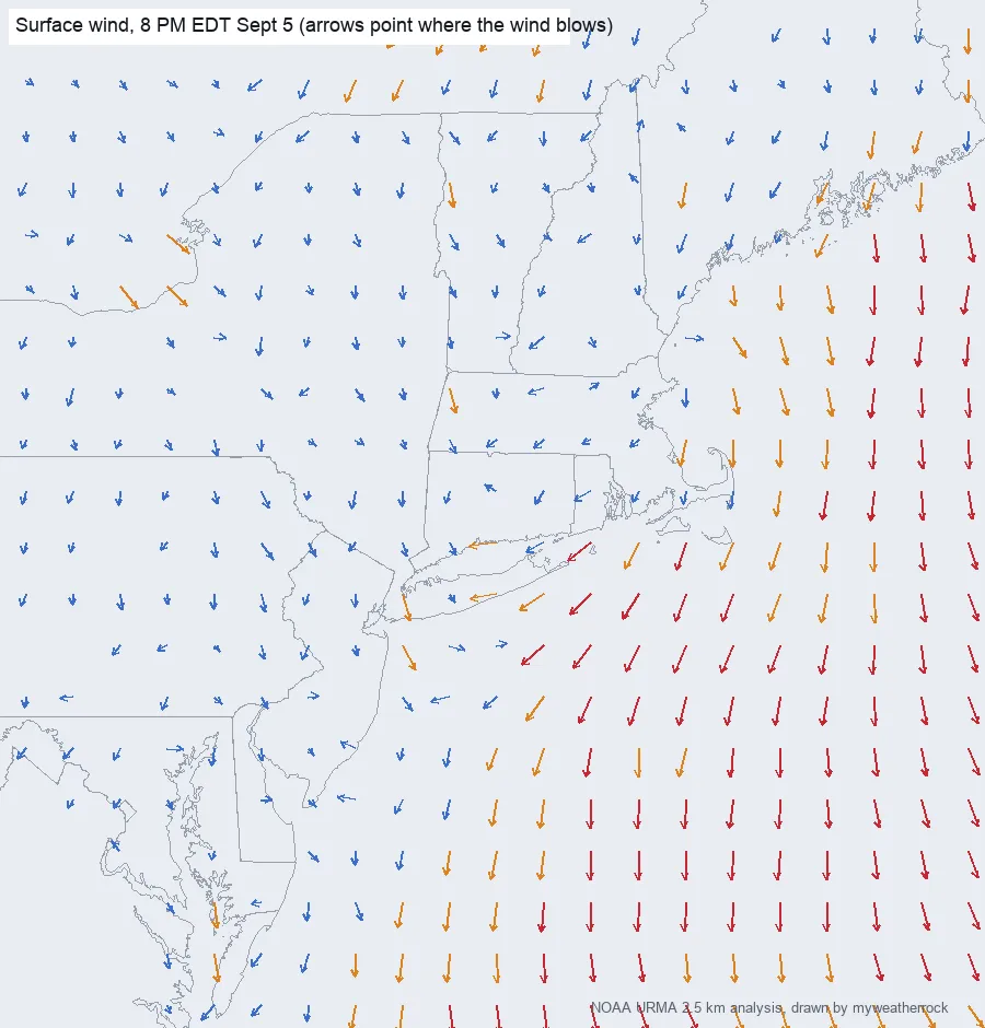
Our own wind field, drawn from the NOAA URMA 2.5 km analysis we keep on our server, shows what that looked like on the ground. Over interior New York and Pennsylvania the arrows point south. Over the waters off New England and the Mid-Atlantic they point south and southwest, strongest offshore. Over Connecticut itself the surface wind was light, about 6 mph in the analysis, because the push was aloft and out over the water; the state sat under the flow rather than in it.
A front and its troughs offshore. The Ocean Prediction Center's forecast for the Mid-Atlantic waters that afternoon had "a slow-moving cold front" reaching the central waters and "a series of low pressure troughs" sliding southeast over the northern waters through Monday. That is where the showers were going. On radar it looks as if something off the Virginia and Delaware coast is drawing the weather toward it, and in a sense it was: the front was the low side of the gradient, and the troughs riding down the flow gave the showers a place to go.
Why it feels so strange
None of these pieces is exotic. Cutoff lows, northeast flow behind a coastal front, wraparound showers: every forecaster in the Northeast has a name for each of them. What is uncommon is the combination sitting over southern New England long enough, in early September, for the showers themselves to travel north to south across a whole state. Our forecasting doctrine treats storm motion as physics: a cell keeps going the way the wind aloft is taking it until it dies. Saturday the wind aloft came from the north, so the cells did too.
How rare is it? Honestly, we do not know yet, and we are not going to guess. We are building the count: storm-motion direction over Connecticut for every storm day from 2010 through 2026, from the archived radar, with the number of storm days each year beside it, plus the direction of the wind aloft over the state year by year from the reanalysis record. If north-to-south days have grown, the count will show it. If they have always been this rare, it will show that too.
What the science says about the jet stream
The question everyone asks is whether the jet stream has changed. Some of that is settled and some is argued, and the piece should say which is which.
Settled, in the peer-reviewed record: the jet streams have moved. Archer and Caldeira, writing in Geophysical Research Letters in 2008, analyzed two reanalysis datasets for 1979 to 2001 and found that "the jet streams have risen in altitude and moved poleward in both hemispheres," and that "in the northern hemisphere, the jet stream weakened." They added that further work was needed to attribute the causes.
Argued: whether a warming Arctic is making the jet wavier and blocking patterns, the stalled lows and highs, more common. Francis and Vavrus, in the same journal in 2012, identified two effects of Arctic warming that "each contribute to a slower eastward progression of Rossby waves in the upper-level flow: weakened zonal winds, and increased wave amplitude." Barnes, in 2013, reexamined that evidence across three reanalyses and reported that "the frequency of blocking occurrence exhibits no significant increase in any season." Both are careful papers, and they disagree. A slower, wavier jet would make a night like Saturday more likely. Whether the record shows that yet is the open question, and no paper we have read dates a change to any single year.
So the honest headline is the one at the top. A stationary low to the northeast, high pressure to the northwest, and a front offshore turned the wind around, and the weather followed it south. The jet stream set the stage, as it always does. Whether it is setting this stage more often than it used to is a question for the count, and we will publish the count.
Where these numbers come from
- Storm motion over Oakville: our own radar frames, cross-correlated frame to frame by myweatherrock's storm-motion tool, 8 PM EDT September 5.
- Radar loop: NOAA MRMS merged reflectivity composite, 20Z September 5 to 04Z September 6, rendered by myweatherrock.
- Wind field: NOAA URMA 2.5 km analysis for 00Z September 6, from the copy myweatherrock keeps for grading its forecasts.
- Surface analysis: NOAA Weather Prediction Center, 00Z September 6, 2026.
- 500 mb analysis: NOAA Storm Prediction Center upper-air chart, 00Z September 6, 2026.
- Forecast discussions: NWS New York (8:04 PM EDT September 5), NWS Boston (7:49 PM EDT), and the NWS Ocean Prediction Center Mid-Atlantic offshore forecast (5:09 PM EDT), quoted as issued.
- Papers: Archer and Caldeira, "Historical trends in the jet streams," Geophysical Research Letters, 2008 (doi 10.1029/2008GL033614); Francis and Vavrus, "Evidence linking Arctic amplification to extreme weather in mid-latitudes," Geophysical Research Letters, 2012 (doi 10.1029/2012GL051000); Barnes, "Revisiting the evidence linking Arctic amplification to extreme weather in midlatitudes," Geophysical Research Letters, 2013 (doi 10.1002/grl.50880). Quotations are from the published abstracts.
More from the Weather Beat
More from the Journal
 THE WEATHER BEAT
Watch or warning? Interior Alaska's snowstorm splits: the mountains now under warnings, Fairbanks still on a watch
OCT 19
THE WEATHER BEAT
Watch or warning? Interior Alaska's snowstorm splits: the mountains now under warnings, Fairbanks still on a watch
OCT 19
 THE WEATHER BEAT
Nor'easter stalls off North Carolina: Hatteras and Ocracoke flood warnings now run to Wednesday, Hampton Roads under advisories
OCT 19
THE WEATHER BEAT
Nor'easter stalls off North Carolina: Hatteras and Ocracoke flood warnings now run to Wednesday, Hampton Roads under advisories
OCT 19
 EXPLAINERS
Why Is the Sky Blue?
AUG 20
EXPLAINERS
Why Is the Sky Blue?
AUG 20
Follow the Journal: RSS · get it by email