THE WEATHER BEAT · SEP 25
Nolo became a hurricane Thursday evening, and the Big Island carries a warning and a watch at the same time
Eighty mph and 290 miles south of Hilo at 11 p.m. HST, moving at 5 mph. The zone forecast for the Hilo side is another 12 to 18 inches of rain.

Key points
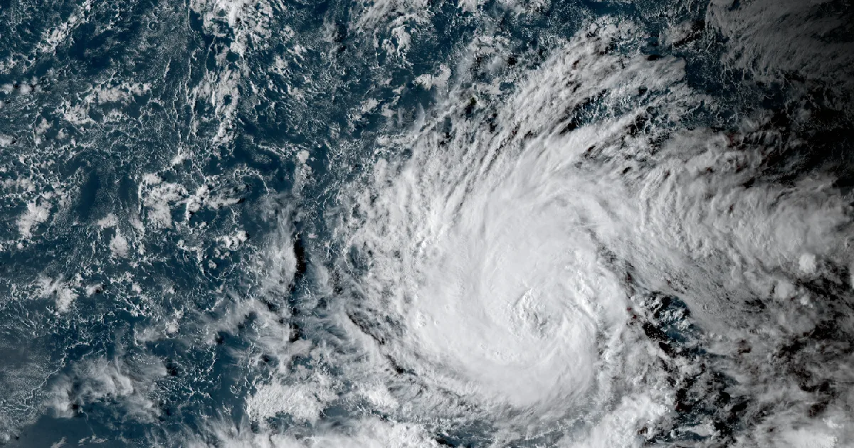
- Nolo became a hurricane Thursday evening. The Honolulu office's 5:08 p.m. HST local statement led with the words "NOLO HAS STRENGTHENED TO A HURRICANE," and by the 11:10 p.m. HST statement it was 80 mph and about 290 miles south of Hilo, moving north-northeast at 5 mph.
- The Big Island is under a Tropical Storm Warning and a Hurricane Watch at the same time, and all of Maui County is under a Tropical Storm Watch. The 11 p.m. HST zone forecast puts additional rain at 12 to 18 inches over the Hilo side of the Big Island, and the local statement uses the phrase "locally catastrophic flash flooding."
- On the other side of the country the nor'easter's wind headlines went up a rung overnight. Mount Holly turned Thursday afternoon's High Wind Watch into a High Wind Warning at 4:43 a.m. EDT Friday for the Jersey and Delaware shore, and Boston's coastal warning takes hold at 8 a.m. this morning.
Nolo found its hurricane strength on Thursday evening, and the Big Island is the island in the way
For two days the storm south of Hawaii was a forecast. On Thursday evening it stopped being one. The National Weather Service office in Honolulu put out its eighteenth local statement on the system at 5:08 p.m. HST and opened it with a single line in capital letters: Nolo has strengthened to a hurricane. At that hour it was 320 miles south of Hilo, at 75 mph, crawling north-northeast at 5 mph.
Six hours later, in the statement at 11:10 p.m. HST, it had closed thirty of those miles and picked up 5 mph. Eighty miles an hour, 290 miles south of Hilo, 15.5 north and 155.6 west, still moving at the pace of a person walking. A hurricane that moves at 5 mph is a hurricane that gets to spend a long time upwind of you, and that is the whole shape of this weekend for the eastern end of the state.
What the forecasters expect next, as of that 11 p.m. HST statement, is a sharp turn to the west late Friday, with Nolo strengthening to a major hurricane and then running westward through the weekend with its center staying south of the islands. The center staying offshore is not the same as the weather staying offshore, and the statement says so in plain words: "impacts from Nolo will be felt well outside the center of the storm."
The Big Island carries two headlines at once, which is worth a second look if you are reading quickly. A Tropical Storm Warning means tropical storm force wind is expected, and it is in force now for all eight Big Island zones from Kona around to Hilo and up over the summits. A Hurricane Watch, in the same zones, means hurricane force wind is possible but not yet expected. The statement's timing line separates them: tropical storm force winds are expected to reach the Big Island as early as midday Friday, with hurricane force winds possible by Friday night. Maui County, which is Maui, Molokai, Lanai and Kahoolawe, is under a Tropical Storm Watch, and the earliest reasonable arrival there is put at predawn Saturday.
The wind is not the number that worries the office most. Rain is. A slow storm dragging deep tropical moisture up the windward slopes of the tallest mountains in the Pacific is the recipe the Hilo side knows best, and the statement's language on it is as strong as these products get: "Excessive rainfall is possible which could lead to locally catastrophic flash flooding and mudslides across windward and southeast Big Island. Flooding can occur even in areas not usually prone to flooding."
Two of the office's own figures for that rain do not match exactly, and both are printed here rather than blended. The statement's island-wide paragraph says additional amounts of 10 to 15 inches are possible on the Big Island, with localized higher amounts of 20 inches. The zone-by-zone forecast issued the same hour goes higher in the wettest places, giving Big Island East, which is Hilo, Pahoa and Volcano, an additional 12 to 18 inches with locally higher amounts, and Big Island Southeast, which is Naalehu and Pahala, an additional 10 to 15. The zone numbers are the local detail; the island paragraph is the summary. The office's evening discussion at 9:07 p.m. HST explains why the figures have room in them, and it is honest about it: "Despite consensus on the position of Nolo, and subsequent placement of deeper moisture, there remains significant differences in the QPF between the global models, particularly over the Kau District of the Big Island." That discussion also notes the totals "were trended down some" from the previous package, and that the chance of localized significant amounts remains.
A Flood Watch has been up since 4:51 p.m. HST Thursday for the Big Island, Maui, Lanai, Molokai and Kahoolawe, running through Saturday afternoon. A High Surf Advisory covers east and southeast facing shores of the Big Island, Maui and Molokai until 6 p.m. HST Saturday, for breaking waves of 7 to 10 feet, rising to 8 to 12 feet on the Big Island on Friday.
One thing to watch for later today, straight from the forecaster who wrote it: the 9:07 p.m. HST discussion said the office was "considering issuing a wind advisory for Kauai and Oahu with the morning package," and that "A High Wind Watch for Oahu Saturday and Saturday night remains a possibility." Nothing has been issued for either island yet. Whether it is depends on where the morning track puts the turn.
Hurricane Nolo, as of the 11 p.m. HST Thursday advisory
| Advisory | Hurricane Nolo Local Statement number 19, 11:10 p.m. HST Thu Sep 24 |
|---|---|
| Position | 15.5N 155.6W, about 290 miles south of Hilo, about 430 miles south-southeast of Honolulu |
| Intensity | 80 mph |
| Movement | North-northeast, 30 degrees, at 5 mph |
| Previous statement | Number 18, 5:08 p.m. HST: 75 mph, 320 miles south of Hilo, north-northeast at 5 mph |
| Forecast | Northward through Friday, sharp turn west late Friday while strengthening to a major hurricane, center passing south of the state through the weekend |
The zone forecast for the Big Island, 11 p.m. HST Thursday
| Zone | Towns named | Peak wind forecast | Additional rain |
|---|---|---|---|
| Big Island East | Hilo, Pahoa, Volcano | 30 to 40 mph, gusts to 55 | 12 to 18 inches, locally higher |
| Big Island Southeast | Naalehu, Pahala | 30 to 40 mph, gusts to 60 | 10 to 15 inches, locally higher |
| Big Island Interior | Bradshaw Army Airfield | 35 to 45 mph, gusts to 70 | 8 to 12 inches, locally higher |
| Big Island Summits | Mauna Kea, Mauna Loa | 45 to 55 mph, gusts to 65 | 8 to 12 inches, locally higher |
| Big Island South | Hawaiian Ocean View Estates | 35 to 45 mph, gusts to 60 | 6 to 10 inches, locally higher |
| Big Island North | Kamuela, Hawi, Honokaa | 40 to 50 mph, gusts to 75 | 3 to 6 inches, locally higher |
| Kona | Kailua-Kona, Captain Cook, Milolii | 30 to 40 mph, gusts to 55 | 2 to 4 inches, locally higher |
| Kohala | Kawaihae, Waikoloa Village, Mahukona | 35 to 45 mph, gusts to 70 | 1 to 3 inches, locally higher |
Every Big Island zone above is under a Tropical Storm Warning and a Hurricane Watch, and each carries a storm surge line reading "The potential for 1 to 3 feet" along the coastal zones. Source: NWS Honolulu tropical cyclone watch and warning statement number 19 and Hurricane Local Statement number 19, both issued 11 p.m. HST Thursday 24 September 2026.
Maui County, the windiest zones in the same product
| Zone | Towns named | Peak wind forecast | Window for tropical storm force winds |
|---|---|---|---|
| Lanai Windward | Shipwreck Beach | 50 to 65 mph, gusts to 95 | until Sunday evening |
| Maui Windward West | Wailuku, Waihee, Kapalua | 45 to 60 mph, gusts to 90 | until Sunday evening |
| Kipahulu | Hamoa | 45 to 60 mph, gusts to 85 | until Monday morning |
| Molokai Southeast | Pukoo | 45 to 60 mph, gusts to 90 | until early Monday morning |
| Maui Leeward West | Lahaina, Olowalu, Napili | 35 to 45 mph, gusts to 60 | until early Sunday morning |
| Maui Central Valley North | Kahului, Puunene | 30 to 40 mph, gusts to 55 | not stated |
| Molokai Leeward South | Kaunakakai, Kualapuu | 30 to 40 mph, gusts to 60 | until early Sunday morning |
These zones are under a Tropical Storm Watch, not a warning. Source: the same watch and warning statement, 11 p.m. HST Thursday.
The East Coast low took its wind warnings a step further overnight
The system that has been sitting off the mid-Atlantic all week, and that both the New York and Boston discussions called a nor'easter on Thursday, spent the overnight hours turning watches into warnings.
Mount Holly went first, at 4:43 a.m. EDT Friday. Thursday afternoon's High Wind Watch for the Delaware Beaches and the New Jersey shore from Monmouth down through Cape May is now a High Wind Warning, in effect from 6 p.m. Friday to 6 a.m. EDT Sunday, for north winds of 30 to 40 mph with gusts up to 60. A Wind Advisory covers the daylight hours ahead of it, until 6 p.m. EDT this evening, for northeast winds of 25 to 35 mph with gusts to 45.
Boston reissued its two High Wind Warnings at 1:46 a.m. EDT, and those are the ones that start soonest. From 8 a.m. this morning until 2 a.m. EDT Sunday, the eastern Massachusetts coast, Cape Cod, the Islands, and both Rhode Island coasts are forecast for northeast winds of 25 to 35 mph gusting to 60, with the warning text saying plainly that "Damaging winds will blow down branches and power lines. Power outages are expected." The Kent County and southeast Providence warning reads the same with north winds of 20 to 30 mph. Thirty-six hours of that, into September trees that still hold a full canopy, is why these are warnings and not advisories.
Friday's High Wind Warnings, coast to coast
| Office | Area | In effect | Forecast |
|---|---|---|---|
| Boston/Norton MA, 1:46 a.m. EDT | Eastern and southeastern Massachusetts coast, Barnstable, Dukes, Nantucket, Bristol, Washington, Newport, Block Island | 8 a.m. Fri to 2 a.m. EDT Sun | NE 25 to 35 mph, gusts to 60 |
| Boston/Norton MA, 1:46 a.m. EDT | Kent and southeast Providence RI | 8 a.m. Fri to 2 a.m. EDT Sun | N 20 to 30 mph, gusts 45 to 60 |
| Mount Holly NJ, 4:43 a.m. EDT | Delaware Beaches, eastern Monmouth, coastal Atlantic, coastal Ocean, Atlantic coastal Cape May | 6 p.m. Fri to 6 a.m. EDT Sun | N 30 to 40 mph, gusts to 60 |
| Great Falls MT, 2:54 a.m. MDT | Northern and Southern High Plains, eastern Glacier, western Toole, central Pondera | 5 p.m. Fri to 6 a.m. MDT Sat | W 30 to 50 mph, gusts to 70 |
| Anchorage AK, 2:47 a.m. AKDT | Atka and Adak | until 9 p.m. AKDT Fri | W 45 to 60 mph, gusts to 75 |
| Anchorage AK, 2:47 a.m. AKDT | Unalaska and Nikolski | until 4 p.m. AKDT Sat | W 35 to 45 mph, then 40 to 50 mph late Fri into Sat, gusts to 60 |
The rest of the country, officially
The Storm Prediction Center's Friday outlook states no severe category at all, and its own summary sentence is the whole story: "Organized severe thunderstorms are not expected Friday." The Center's preliminary storm reports page and the Weather Prediction Center's day 1 excessive rainfall page both answered our fetch with a 403 error this morning, the seventeenth straight day they have done so, so neither is quoted here. Two Red Flag Warnings from Reno run until 10 p.m. PDT Friday in the West Humboldt Basin, the Lahontan Basin and the northern Sierra Front, and Frost Advisories were out in four offices overnight.
Nothing in the Hawaii or East Coast sections above has happened yet. Those are expectations, each framed by the hour its product was issued.
This is a summary of official warnings, not emergency information. For live warnings see weather.gov and your local officials.
The rock's live forecast for the places in this story
More from the Journal

Follow the Journal: RSS · get it by email