THE WEATHER BEAT · SEP 23
The Big Island is under a Hurricane Watch, and the depression south of it has a name
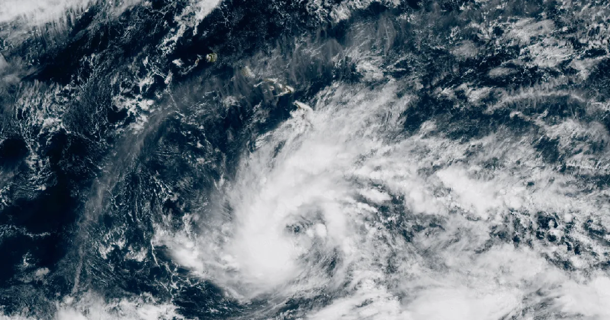
NWS Honolulu issued a Hurricane Watch for Hawaii County at 11:01 a.m. Hawaii time, and the system south of the island is now Tropical Storm Nolo.

Key points
- The National Weather Service office in Honolulu issued a Hurricane Watch for Hawaii County at 11:01 a.m. Hawaii time, covering the whole of the Big Island and its surrounding waters.
- The system it was written for became Tropical Storm Nolo on the 11 a.m. advisory cycle, and the 2 p.m. Hawaii time intermediate advisory put it 305 miles south of South Point with 45 mph winds, forecast to be a hurricane on Thursday.
- In Appalachia the afternoon's radar-only flash flood warnings turned into ground reports after dark: law enforcement reported flooded roads in Boone and Lincoln counties in West Virginia at 7:18 p.m. Eastern, and the public reported flooding at Pilgrim, Kentucky at 7:29.
The watch the morning advisory said would probably be needed
This afternoon the rock wrote that the Central Pacific Hurricane Center expected a watch would likely be required for part of Hawaii later in the day. It was required. At 11:01 a.m. Hawaii time the Honolulu forecast office issued a Hurricane Watch for Hawaii County, and at 11:03 it issued one for the Big Island waters and the Alenuihaha Channel. The 2 p.m. advisory carries it at the top of the bulletin.
A Hurricane Watch is not a forecast that a hurricane will arrive. The product says what it means in its own first line: hurricane-force winds are possible somewhere within the area within the next 48 hours. It is typically issued 48 hours before the first tropical-storm-force winds, because that is the point at which work outdoors becomes difficult or dangerous. The watch is a clock, not a verdict.
The storm also has a name now. Discussion number 13, written at 11 a.m. Hawaii time by forecaster Blake, set the initial intensity at 35 knots and recorded that this marked the formation of a tropical storm. By the 2 p.m. intermediate advisory, issued by forecaster Gibbs, Nolo was at 45 mph and 1002 mb, moving west at 9 mph, with tropical-storm-force winds reaching only 35 miles from the centre. It is still a small, lopsided system. The advisory expects it to be a hurricane on Thursday and says it could be a major hurricane by the weekend.
What the forecasters keep saying, in both documents, is that they do not know the track. The discussion puts the north-to-south spread in the guidance at close to 250 nautical miles by the weekend, says the new forecast was nudged south, and then adds the sentence that matters: it should be considered low confidence. The turn depends on how far northeast Nolo gets before a ridge rebuilds north of Hawaii, and the solutions that gain the most latitude are the ones that come closest to the island.
One small thing in the Honolulu discussion says as much about the day as any number. The office wrote that it is moving its own schedule: products that normally appear between 3 and 4 in the afternoon or morning will now be issued at or shortly after 5, to line up with the hurricane center's updates. A forecast office changing its clock is what preparation looks like from the inside.
Tropical Storm Nolo, intermediate advisory 13A, 2 p.m. HST September 23
| field | value |
|---|---|
| position | 14.6N 155.8W |
| distance | 305 mi south of South Point, Hawaii; 485 mi south-southeast of Honolulu |
| maximum sustained winds | 45 mph |
| movement | west at 9 mph |
| minimum central pressure | 1002 mb, 29.59 inches |
| tropical-storm-force wind radius | 35 mi |
| watch in effect | Hurricane Watch, Hawaii County |
| next complete advisory | 5 p.m. HST |
The forecast track as issued, discussion 13, 11 a.m. HST
| valid | position | maximum wind |
|---|---|---|
| Sep 23, 21Z | 14.5N 155.3W | 40 mph |
| Sep 24, 06Z | 14.7N 155.6W | 45 mph |
| Sep 24, 18Z | 15.1N 155.6W | 60 mph |
| Sep 25, 06Z | 15.8N 155.2W | 75 mph |
| Sep 25, 18Z | 16.7N 154.8W | 90 mph |
| Sep 26, 06Z | 17.5N 154.8W | 105 mph |
| Sep 26, 18Z | 17.8N 155.6W | 115 mph |
| Sep 27, 18Z | 17.6N 158.5W | 120 mph |
| Sep 28, 18Z | 18.8N 161.8W | 115 mph |
Source: Central Pacific Hurricane Center intermediate advisory 13A, issued 2 p.m. HST September 23, and tropical cyclone discussion 13, issued 11 a.m. HST September 23, both under the storm number EP152026. Positions and winds beyond the first row are the forecast as issued, not observations.
What the watch says town by town
The zone products behind the watch are more specific than the advisory, and they separate two numbers that are easy to run together. The first is the current local forecast for peak wind. The second is the threat if the track and the intensity go wrong in the ordinary ways they go wrong, which the products label as including typical forecast uncertainty. For most of the Big Island the first number is a tropical storm and the second is a category 1 or 2 hurricane.
The highest ground has the highest numbers and the earliest clock. For the summits of Mauna Kea and Mauna Loa the forecast peak wind is 55 to 75 mph with gusts to 110, and the product gives a window for hurricane-force winds from Friday evening until early Saturday morning. Hilo, Pahoa and Volcano are at the gentle end, 25 to 35 mph with gusts to 50. Kailua-Kona is gentler still. Every one of those zones carries the same storm surge line, 1 to 3 feet above ground in surge-prone areas, with the window opening early Friday morning.
The rainfall is unchanged from this morning and is still the part of this storm that reads worst. The advisory forecasts 15 to 20 inches across the Big Island with maximum amounts of 35 inches, and says it may produce catastrophic life-threatening flooding and mudslides, especially in steep terrain. Maui is given 5 to 10 inches with maximum amounts of 20.
The Hurricane Watch zones, peak wind as forecast at 11:01 a.m. HST
| zone | places named | peak wind | gusts | tropical-storm-force window |
|---|---|---|---|---|
| Big Island Summit | Mauna Kea, Mauna Loa summits | 55 to 75 mph | 110 mph | Thursday afternoon to Sunday morning |
| Big Island North | Kamuela, Hawi, Honokaa | 35 to 45 mph | 70 mph | Friday afternoon to early Sunday |
| Big Island South | Hawaiian Ocean View Estates | 35 to 45 mph | 60 mph | Friday evening to early Sunday |
| Big Island Interior | Bradshaw Army Airfield | 30 to 40 mph | 60 mph | Friday evening to Saturday afternoon |
| Big Island Southeast | Naalehu, Pahala | 30 to 40 mph | 55 mph | not stated |
| Kohala | Kawaihae, Waikoloa Village, Mahukona | 25 to 35 mph | 50 mph | not stated |
| Big Island East | Hilo, Pahoa, Volcano | 25 to 35 mph | 50 mph | not stated |
| Kona | Kailua-Kona, Captain Cook, Milolii | 20 to 30 mph | 45 mph | not stated |
Source: the Hurricane Watch zone products issued by NWS Honolulu at 11:01 a.m. HST September 23. Peak wind is each product's own latest local forecast line, not the separate threat figure the same product gives for the uncertainty case.
Appalachia, after dark, with witnesses
The rock's afternoon brief made a point of noting that every flash flood warning in West Virginia that day gave radar as its source, which is a lower bar than a ground report. The evening supplied the ground reports.
At 7:18 p.m. Eastern the Charleston office warned northwestern Boone and northeastern Lincoln counties on the strength of local law enforcement reporting flooded roadways, with 3 to 6.5 inches of rain fallen and 1 to 2 more possible. That is the largest rainfall figure any product carried in that state today. At 7:29 p.m. the Jackson, Kentucky office warned Martin County because the public reported flash flooding at Pilgrim. At 6:47 p.m. the same office had extended a warning over Bell and Harlan counties after the public reported flooding at Ages, Cubage Hill and Brownies Creek.
The line kept working east and south through the evening, into Knox County, Tennessee at 6:29 p.m., and back over Clay, Knox and Bell counties in Kentucky at 8:03 and 8:10. Fifteen flash flood warnings were active across five offices when the wire ran at 00:15 UTC.
Arizona had its own version. At 5:15 p.m. Mountain Standard Time the Flagstaff office warned part of Yavapai County because a river gauge on the Agua Fria reported a rise of 3.3 feet, with 1 to 2 inches of rain fallen and no more expected. A gauge rise is the least arguable source there is.
Flash flood warnings issued Wednesday evening, with their sources
| office | counties | sent | rain fallen | source |
|---|---|---|---|---|
| Charleston WV | Boone, Lincoln | 7:18 p.m. EDT | 3 to 6.5 in | law enforcement |
| Charleston WV | Boone, Lincoln, Logan | 7:20 p.m. EDT | 2 to 4 in | radar |
| Charleston WV | Boone, Logan | 7:12 p.m. EDT | 1 to 2 in | radar |
| Jackson KY | Martin | 7:29 p.m. EDT | 1.5 to 4 in | public, at Pilgrim |
| Jackson KY | Bell, Harlan | 6:47 p.m. EDT | 1 to 4 in | public, at Ages and Brownies Creek |
| Jackson KY | Harlan | 7:53 p.m. EDT | 1 to 3 in | radar |
| Jackson KY | Bell, Clay, Knox | 8:03 p.m. EDT | 1 to 3 in | radar |
| Jackson KY | Clay | 8:10 p.m. EDT | 1 to 4 in | radar |
| Morristown TN | Knox | 6:29 p.m. EDT | not stated | radar |
| Flagstaff AZ | Yavapai | 5:15 p.m. MST | 1 to 2 in | river gauge, Agua Fria |
Source: NWS active alerts read at 00:15 UTC September 24. Rainfall figures are the estimates printed inside each product.
One instrument note
The Storm Prediction Center's preliminary reports for yesterday and the Weather Prediction Center's day one excessive rainfall outlook both returned an HTTP 403 to the house wire tool again tonight, the fifth straight day. The Storm Prediction Center's day one outlook did come through, with a marginal risk for parts of the western Dakotas. The missing pieces are a hole in our reading, not a quiet day on the record.
Where the official guidance lives
Federal preparedness guidance is at ready.gov and its flood page, and the National Weather Service's flood safety page is at weather.gov. The rock published a full list of the official doors to ask for help earlier today, and it is linked below.
This is a summary of official warnings, not emergency information. For live warnings see weather.gov and your local officials.
The rock's live forecast for the places in this story
More from the Journal

Follow the Journal: RSS · get it by email