THE WEATHER BEAT · SEP 23
A depression 320 miles south of the Big Island is forecast to arrive as a hurricane
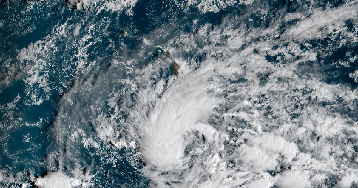
The Central Pacific Hurricane Center's 5 a.m. advisory puts Tropical Depression Fifteen-E near the Big Island Friday and Saturday as a hurricane.

Key points
- The Central Pacific Hurricane Center's 5 a.m. Hawaii time advisory has Tropical Depression Fifteen-E about 320 miles south-southeast of South Point, and forecasts it to approach the Big Island on Friday and Saturday as a hurricane.
- The same advisory calls for 15 to 20 inches of rain on the Big Island with maximum amounts near 35 inches, and says a hurricane or tropical storm watch will likely be required for part of the state later today.
- On the other side of the country the coastal low's fourth day brought the Baltimore and Washington office into the coastal flood warning list at 3:08 p.m. Eastern, the first time it has held one this week.
Hawaii, and a depression the forecasters are not treating as a depression
The system south of Hawaii is a tropical depression with 35 mph winds, which is the weakest thing the hurricane center names. Almost nothing else about the products written for it this morning reads that way.
At 5 a.m. Hawaii time the Central Pacific Hurricane Center put the center of Tropical Depression Fifteen-E at 14.5 North, 154.4 West, about 320 miles south-southeast of South Point on the Big Island, drifting west-northwest at 6 mph. The advisory, number 12, was issued out of the National Hurricane Center in Miami. It says the depression is expected to become a tropical storm later today, a hurricane on Thursday, and possibly a major hurricane by the weekend, and that on the forecast track it approaches the Big Island on Friday and Saturday. The watches and warnings section carries no product yet. What it carries instead is a sentence: a hurricane or tropical storm watch will likely be required for a portion of the state later today.
The rainfall numbers are the part worth reading twice. The advisory forecasts 15 to 20 inches across the Big Island with maximum amounts of 35 inches, and says that rain may produce catastrophic life threatening flooding and mudslides, especially in areas of steep terrain. Maui is given 5 to 10 inches with maximum amounts of 20. The rest of the islands are given 1 to 3 inches.
The forecaster on duty, Blake, wrote the uncertainty down rather than around. The discussion issued at the same hour says the low level circulation is not well aligned with the deep convection yet, that satellite intensity estimates spread from 25 to 40 knots, and that a trough is expected to force a sharp westward turn while the cyclone is close to the Big Island. Of that turn it says plainly that it is impossible to know exactly when it will happen, and that there is a large north to south spread in the guidance. The forecast was raised anyway, because the best performing aids showed a major hurricane, and the environment ahead of the storm has low shear and sea surface temperatures of 28 to 29 degrees Celsius.
The Honolulu forecast office put a flood watch up at 3:44 a.m. Hawaii time, in effect from noon today through Saturday afternoon, covering the Big Island, Maui, Lanai, Molokai and Kahoolawe. Its own morning discussion, written at 4:15 a.m., says the depression redeveloped overnight just over 400 miles south-southeast of Hilo, that windward Big Island collected roughly a quarter to a half inch of rain overnight, and that the office expects the system to be at hurricane strength when significant impacts could begin on Friday. It also names what the advisory had not yet: the office wrote that the latest forecast calls for Fifteen-E to intensify into Tropical Storm Nolo.
Tropical Depression Fifteen-E, advisory 12
| field | value |
|---|---|
| position | 14.5N 154.4W |
| distance | 320 mi south-southeast of South Point, Hawaii; 525 mi south-southeast of Honolulu |
| maximum sustained winds | 35 mph |
| movement | west-northwest at 6 mph |
| minimum central pressure | 1004 mb, 29.65 inches |
| next complete advisory | 11 a.m. HST |
The forecast track, as issued
| valid | position | maximum wind |
|---|---|---|
| Sep 24, 00Z | 14.7N 155.2W | 45 mph |
| Sep 24, 12Z | 15.0N 155.5W | 60 mph |
| Sep 25, 00Z | 15.7N 155.2W | 75 mph |
| Sep 25, 12Z | 16.7N 154.8W | 90 mph |
| Sep 26, 00Z | 17.6N 154.5W | 105 mph |
| Sep 26, 12Z | 18.2N 154.7W | 115 mph |
| Sep 27, 12Z | 18.1N 157.0W | 115 mph |
| Sep 28, 12Z | 18.7N 160.2W | 110 mph |
Forecast rainfall, by island group
| area | total | maximum |
|---|---|---|
| Big Island | 15 to 20 in | 35 in |
| Maui | 5 to 10 in | 20 in |
| remainder of the state | 1 to 3 in | 6 in |
Source: Central Pacific Hurricane Center public advisory 12 and forecast discussion 12 for Tropical Depression Fifteen-E, both issued 5 a.m. HST September 23, and the NWS Honolulu area forecast discussion issued 4:15 a.m. HST September 23. Positions and winds are the forecast as issued, not an observation.
The East Coast low, day four
The coastal low that has been running this week's coverage kept its ladder climbing on Wednesday afternoon. At 3:08 p.m. Eastern the Baltimore and Washington office issued coastal flood warnings for the Anne Arundel and St. Marys shorelines, its first of the week. That office held three watches and no warnings when the wire ran this morning, and its own morning discussion said the conversion decision was still to be made.
The Anne Arundel product gives up to one foot of inundation above ground level from 11 p.m. tonight to 11 a.m. Friday, and names the stage at which it starts: at 3.2 feet, water begins to approach businesses on Dock Street in Annapolis, the City Dock parking lot is flooded, and Compromise Street is flooded. The St. Marys product runs from 9 p.m. tonight to 5 p.m. Friday, with water covering roads on Saint George Island at 3.5 feet. The stages are printed with no datum, so they are copied here as written.
The largest numbers on the coast are still south of that. The Newport and Morehead City office, in a product sent at 4:48 a.m. Eastern, forecasts 2 to 4 feet of inundation for Hatteras Island and Ocracoke Island from 2 p.m. Wednesday to 11 p.m. Friday, and writes that portions of Highway 12 will be inundated and that some critical infrastructure will be inundated. Storm watches for Thursday evening through Saturday were still standing over the New England and New York waters, unchanged in number and in office since this morning.
Coastal flood warnings active at 3:15 p.m. Eastern, by office
| office | warnings |
|---|---|
| Wakefield VA | 9 |
| Mount Holly NJ | 4 |
| Baltimore MD and Washington DC | 2 |
| Newport and Morehead City NC | 2 |
| Anchorage AK | 1 |
Other coastal products on the same stretch
| product | count | offices |
|---|---|---|
| high surf advisory | 8 | Mount Holly 3 at 3:00 p.m. EDT, Wakefield 3 at 2:01 p.m., Morehead City 2 at 4:48 a.m. |
| wind advisory | 6 | Mount Holly, Wakefield, Morehead City, plus 3 at Anchorage |
| storm watch | 10 | Boston and Norton 8, Upton 1, Mount Holly 1 |
Source: NWS active alerts read at 19:15 UTC September 23. Counts are of individual products, not of counties.
Inland, an afternoon of small warnings
Away from both coasts the afternoon belonged to short flash flood warnings over saturated ground. The Charleston, West Virginia office issued four of them between 2:04 and 3:09 p.m. Eastern. The 2:04 p.m. extension for northwestern Boone and east central Lincoln counties reported 3 to 5 inches of rain already fallen, used the wording life threatening flash flooding, and named Route 119 between mile markers 54 and 58. The 3:09 p.m. warning for parts of Roane, Calhoun and Gilmer counties listed Chloe, Orma, Nicut and Tariff. All four gave radar as their source, which is a lower bar than a ground report.
The Peachtree City office issued one at 3:02 p.m. Eastern for northwestern Gilmer and east central Murray counties in north Georgia, with 2 to 3 inches fallen and Fort Mountain State Park named as a location that will experience flooding.
Behind the warnings sat a wide field of watches. The Charleston office's flood watch, issued at 11:07 a.m. Eastern, runs until 10 p.m. across nine West Virginia counties plus Lawrence County in Kentucky and Buchanan and Dickenson counties in Virginia, and says the showers are moving slowly over soils compromised from recent rainfall. The Jackson, Kentucky office watch covers twenty counties until 10 p.m. In the Southwest, Albuquerque, Midland, El Paso, Amarillo, Grand Junction and Pueblo all carried flood watches running into Thursday night and, in the Texas and Oklahoma panhandles, Friday morning.
Flash flood warnings issued Wednesday afternoon
| office | counties | sent EDT | until EDT | rain reported |
|---|---|---|---|---|
| Charleston WV | Boone, Lincoln | 2:04 p.m. | 5:30 p.m. | 3 to 5 in |
| Charleston WV | Lincoln, Wayne | 2:33 p.m. | 5:30 p.m. | 1.5 to 3 in |
| Charleston WV | Gilmer | 2:40 p.m. | 4:15 p.m. | 1.5 to 2 in |
| Charleston WV | Roane, Calhoun, Gilmer | 3:09 p.m. | 6:15 p.m. | 1 to 2 in |
| Peachtree City GA | Gilmer, Murray | 3:02 p.m. | 7:00 p.m. | 2 to 3 in |
Source: NWS active alerts read at 19:15 UTC September 23. Rainfall figures are the radar estimates quoted inside each product.
One instrument note
The Storm Prediction Center's preliminary storm reports for yesterday and the Weather Prediction Center's day one excessive rainfall outlook both returned an HTTP 403 to the house wire tool again today, as they have every day since September 19. So this brief carries no yesterday report count. That is a gap in our reading, not a quiet day on the record.
Where the official guidance lives
For anyone in Hawaii reading this days ahead of the storm, the federal preparedness guidance is at ready.gov, the flood page at ready.gov/floods, and the National Weather Service's own flood safety page at weather.gov/safety/flood. Those are guidance pages, not aid applications, and nothing on them is quoted here.
This is a summary of official warnings, not emergency information. For live warnings see weather.gov and your local officials.
The rock's live forecast for the places in this story
More from the Journal

Follow the Journal: RSS · get it by email