THE WEATHER BEAT · SEP 24
Nolo forecast to be a hurricane tonight, with a watch up for the Big Island
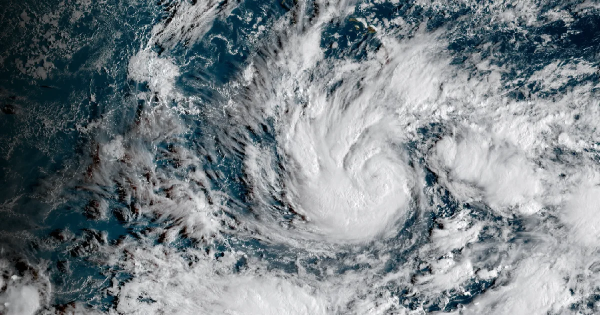
A stationary tropical storm 285 miles south of the Big Island was forecast to become a hurricane tonight, with 15 to 20 inches of rain in the advisory.

Key points
- The Central Pacific Hurricane Center's 8 a.m. HST intermediate advisory on Tropical Storm Nolo carried the line "NOLO FORECAST TO BE A HURRICANE LATER TODAY," with a Hurricane Watch in effect for Hawaii County and forecast rainfall of 15 to 20 inches on the Big Island.
- NWS Honolulu's zone products put the peak wind forecast at 25 to 35 mph in Kona and 55 to 75 mph on the Mauna Kea and Mauna Loa summits, with a separate worst-case column that runs higher.
- On the other side of the country, NWS Boston issued a High Wind Warning at 1:46 p.m. EDT for the eastern Massachusetts and Rhode Island coasts, and coastal flood warnings ran from Hatteras to New Jersey.
Nolo sat still, and got stronger
A tropical storm that is not going anywhere is an unusual thing to read in an advisory, and that is what the Central Pacific Hurricane Center wrote at 8 a.m. HST: present movement, stationary. Nolo was near 14.9 North, 156.1 West, about 285 miles south of South Point on the Big Island, with maximum sustained winds up to 65 mph and a central pressure of 995 mb.
Standing still did not mean standing down. The 5 a.m. HST discussion said an inner core was forming, and that warm water, low shear and a moist middle atmosphere had lined up: "conditions appear to be coming together for rapid intensification." The forecast is for a hurricane tonight and a major hurricane as the storm nears the Big Island on Saturday. The intermediate advisory three hours later put that in its title line.
The forecasters were plain about what they do not know. A mid-latitude trough is expected to pull Nolo north and north-northeast, then step aside for a ridge that turns the storm sharply west this weekend. "The big question is how close does Nolo get before making that turn," the discussion said, "with notable run-to-run inconsistencies in much of the guidance." It called this a more uncertain forecast than normal, and said a track closer to the island could substantially increase the wind threat over higher terrain and downwind of the ridges.
The Hurricane Watch for Hawaii County held from 4:54 a.m. HST. Key message one said a Hurricane Warning would likely be required for the Big Island later today.
| Nolo, 8 a.m. HST Thursday | value |
|---|---|
| Position | 14.9N 156.1W |
| Distance from South Point, Hawaii | 285 mi, 460 km |
| Distance from Honolulu | 455 mi, 735 km |
| Maximum sustained winds | 65 mph, 100 km/h |
| Movement | Stationary |
| Minimum central pressure | 995 mb, 29.39 in |
| Tropical storm force wind radius | 90 mi, 150 km |
Source: NWS Central Pacific Hurricane Center Tropical Storm Nolo Intermediate Advisory 16A, WTPA32 PHFO 241800, and Discussion 16, WTPA42 PHFO 241450.
The rain is the part the advisory called catastrophic
For the Big Island the advisory forecast 15 to 20 inches with maximum amounts of 35 inches, and said that rainfall "could produce catastrophic life-threatening flooding and mudslides, especially in areas of steep terrain." Maui was given 5 to 10 inches with maximum amounts of 20. The rest of the chain was given 1 to 3 inches with isolated flooding possible.
Key message two said the time to finish preparations for heavy rain and flooding on the Big Island is now, with periods of heavy rain continuing over the Big Island and Maui through the weekend.
Two wind columns, and they are supposed to differ
The local Hurricane Watch products from NWS Honolulu carry two wind numbers for every zone, and reading only one of them misleads in one direction or the other. The peak wind forecast is what the office currently expects. The threat line underneath it is the reasonable worst case, the number that includes normal uncertainty in track, size and intensity. Kona's peak forecast was the lowest on the island and its threat line was not.
| Big Island zone | towns named | peak wind forecast | worst-case threat line |
|---|---|---|---|
| Summit | Mauna Kea Summit, Mauna Loa Summit | 55 to 75 mph, gusts to 95 | equivalent Category 1 hurricane force in the local forecast |
| South | Hawaiian Ocean View Estates | 45 to 55 mph, gusts to 80 | above the peak forecast |
| North | Kamuela, Hawi, Honokaa | 35 to 45 mph, gusts to 70 | potential for wind 58 to 73 mph |
| Interior | Bradshaw Army Airfield | 35 to 45 mph, gusts to 70 | above the peak forecast |
| Southeast | Naalehu, Pahala | 35 to 45 mph, gusts to 65 | above the peak forecast |
| Kohala | Kawaihae, Waikoloa Village, Mahukona | 35 to 45 mph, gusts to 60 | above the peak forecast |
| East | Hilo, Pahoa, Volcano | 30 to 40 mph, gusts to 60 | above the peak forecast |
| Kona | Kailua-Kona, Captain Cook, Milolii | 25 to 35 mph, gusts to 50 | above the peak forecast |
Source: NWS Honolulu Hurricane Watch zone products issued 4:54 a.m. HST September 24. The window given for tropical storm force wind on the north side of the island was Friday morning until Sunday morning.
The Atlantic coast moved up a rung
The low off the East Coast did what the marine products had been pointing at all week, and the first big land product came from New England. NWS Boston issued a High Wind Warning at 1:46 p.m. EDT for eastern Essex, Suffolk, the eastern Norfolk and Plymouth shore, Cape Cod, Martha's Vineyard, Nantucket, and the Rhode Island coast including Block Island, plus a second one inland for Providence and Kent counties. Northeast winds of 25 to 35 mph with gusts of 45 to 60 mph were forecast from 8 a.m. Friday to 2 a.m. EDT Sunday.
The office added the detail no marine bulletin carries. The long duration of the winds, it wrote, "coupled with heavy rain and fully leafed trees may exacerbate the risk for tree damage and power outages." September trees still hold their sails.
Farther south the story is the tide. Nineteen coastal flood warnings were active Thursday afternoon, from NWS Wakefield in Virginia, NWS Baltimore and Washington, NWS Mount Holly in New Jersey and NWS Newport and Morehead City in North Carolina. In Annapolis the 2:34 p.m. EDT warning put the number on the street: at 3.2 feet, water begins to approach businesses on Dock Street, the City Dock parking lot floods, and Compromise Street floods. The next high tides at the Naval Academy gauge were given as 4:25 p.m. and 4:42 a.m.
| product | office | area | issued |
|---|---|---|---|
| High Wind Warning | Boston/Norton MA | eastern Massachusetts coast, south coasts of Rhode Island and Massachusetts | 1:46 p.m. EDT Sep 24 |
| High Wind Watch | Mount Holly NJ | Delaware Beaches, Eastern Monmouth, coastal Cape May, Atlantic, Ocean | 3:03 a.m. EDT Sep 24 |
| Coastal Flood Warning, 9 zones | Wakefield VA | Hampton Roads, Eastern Shore, Middle Peninsula, Northern Neck | 2:57 p.m. EDT Sep 24 |
| Coastal Flood Warning, 3 zones | Baltimore MD/Washington DC | Anne Arundel, Alexandria and Arlington shoreline, St. Marys | 2:34 p.m. EDT Sep 24 |
| Coastal Flood Warning, 2 zones | Newport/Morehead City NC | Hatteras Island, Ocracoke Island | 2:39 p.m. EDT Sep 24 |
| Coastal Flood Warning, 4 zones | Mount Holly NJ | Delaware and New Jersey coast, Kent and inland Sussex | 12:57 p.m. EDT Sep 24 |
Source: NWS active alerts, read at 7:30 p.m. UTC September 24.
The rest of the country, briefly
The Storm Prediction Center's day one outlook topped out at Marginal, and its summary read: "A couple of marginally severe thunderstorms are possible late this afternoon into the early evening across parts of the southern High Plains." Red flag warnings covered parts of western Nevada and Modoc County, California. NWS Phoenix had one flash flood warning for parts of Maricopa and Pinal counties, sent 10:09 a.m. MST and set to expire at 1:15 p.m. Alaska, as it has all week, carried most of the country's marine weather: of 137 gale warnings nationwide, the largest share belonged to NWS Anchorage.
One honest note on sourcing. The Storm Prediction Center's preliminary storm reports page and the Weather Prediction Center's day one excessive rainfall page both returned HTTP 403 to this server again today, the thirteenth day in a row, so yesterday's preliminary report counts are not in this brief. That is a fetch failure on our side, not a quiet day on the plains.
This is a summary of official warnings, not emergency information. For live warnings see weather.gov and your local officials.
The rock's live forecast for the places in this story
More from the Journal

Follow the Journal: RSS · get it by email