THE WEATHER BEAT · SEP 24
The week's coastal low became a nor'easter in the discussions, and Boston wrote the first High Wind Warning
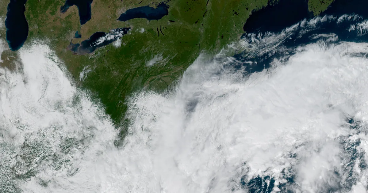
Boston put a High Wind Warning up at 1:46 this afternoon, and the forecast for the Massachusetts coast is northeast gusts of 45 to 60 mph Friday.

Key points
- The National Weather Service office in Boston issued a High Wind Warning at 1:46 p.m. EDT Thursday for the eastern Massachusetts coast, Cape Cod, the Islands and the south coasts of Rhode Island and Massachusetts, in effect from 8 a.m. Friday to 2 a.m. EDT Sunday, for northeast gusts of 45 to 60 mph.
- Two other offices put wind headlines out the same afternoon: New York at 2:29 p.m. EDT for New York City, Long Island and most of southern Connecticut, and Mount Holly at 4:10 p.m. EDT for the Jersey and Delaware shore, where a High Wind Watch carries the words "widespread power outages are possible."
- Both forecast discussions used the same word for the low that has been sitting off the coast all week. The New York discussion at 6:35 p.m. EDT called it "an early season nor'easter."
The week's low stopped being a water story this afternoon
Since Monday the coastal headlines from Virginia to Maine have been about water: coastal flood watches, then warnings, then gale watches that became gale warnings. Thursday afternoon the same system picked up a second kind of headline, and it reached a long way inland.
The office in Boston went first, at 1:46 p.m. EDT. A High Wind Warning for the eastern Massachusetts coast, Barnstable, Dukes and Nantucket, and the south coasts of Rhode Island and Massachusetts down to Block Island. The expected numbers are northeast winds of 25 to 35 mph with gusts of 45 to 60, starting at 8 a.m. Friday and running until 2 a.m. EDT Sunday. The warning text does not hedge on what that does: "Damaging winds will blow down trees and power lines. Power outages are expected."
The same minute, the same office wrote a Wind Advisory for the inland counties behind it, including Hartford, Tolland and Windham in Connecticut. Gusts there are put at 35 to 50 mph. What the forecasters added underneath is the part worth reading twice, because it is about the calendar rather than the storm: "The long duration of the winds coupled with heavy rain and fully leafed trees may exacerbate the risk for tree damage and power outages." The Boston discussion at 7:33 p.m. EDT made the same point and then went further, saying that "whether or not places hit specific high wind criteria is less important that the long duration combined with the fully leafed trees." A September tree holds a full canopy. The same gust that a bare January tree shrugs off can take a limb down now.
New York followed at 2:29 p.m. EDT with a Wind Advisory for Long Island, New York City, southern Westchester and most of southern Connecticut, from 2 p.m. Friday to 6 a.m. EDT Sunday, with north winds of 20 to 25 mph and gusts to 55. Mount Holly was last, at 4:10 p.m. EDT, pairing a Wind Advisory for Friday with a High Wind Watch for Friday evening into Saturday afternoon along the Delaware Beaches and the New Jersey coast from Monmouth down through Cape May. The watch numbers are north winds of 30 to 40 mph with gusts up to 60 possible.
The wind headlines, Thursday afternoon
| Office | Product | Issued EDT | Where | Winds and gusts | In effect |
|---|---|---|---|---|---|
| Boston/Norton MA | High Wind Warning | 1:46 p.m. | Eastern Essex, Suffolk, Eastern Norfolk, Eastern and Southern Plymouth, Southern Bristol, Barnstable, Dukes, Nantucket, Bristol RI, Washington RI, Newport RI, Block Island | NE 25 to 35, gusts 45 to 60 | 8 a.m. Fri to 2 a.m. Sun |
| Boston/Norton MA | High Wind Warning | 1:46 p.m. | Southeast Providence, Western Kent, Eastern Kent | NE 20 to 30, gusts 45 to 60 | 8 a.m. Fri to 2 a.m. Sun |
| Boston/Norton MA | Wind Advisory | 1:46 p.m. | Hartford CT, Tolland CT, Windham CT, Northern Worcester MA, Northern Middlesex MA, Eastern Hampden MA | NE 15 to 25, gusts 35 to 50 | noon Fri to 2 a.m. Sun |
| New York NY (Upton) | Wind Advisory | 2:29 p.m. | Long Island, New York City, Southern Westchester, southern Connecticut | N 20 to 25, gusts to 55 | 2 p.m. Fri to 6 a.m. Sun |
| Mount Holly NJ | Wind Advisory | 4:10 p.m. | Delaware Beaches, Eastern Monmouth, Atlantic Coastal Cape May, Coastal Atlantic, Coastal Ocean | NE 25 to 35, gusts to 45 | until 6 p.m. Fri |
| Mount Holly NJ | High Wind Watch | 4:10 p.m. | same five zones | N 30 to 40, gusts to 60 possible | Fri evening to Sat afternoon |
All figures are the products' own. Times are the issue times printed on each product.
The water headlines kept coming too
At 6:03 p.m. EDT the New York office rewrote its coastal flood headlines for Long Island and the city shoreline. The watches carry one to two feet of inundation above ground level as possible in vulnerable areas near the waterfront, from Friday afternoon or evening through Saturday. High surf goes with them: breaking waves of 5 to 9 feet in the surf zone off Brooklyn and southern Queens, and 8 to 11 feet off Suffolk County.
Boston's Coastal Flood Watch, issued at 1:11 p.m. EDT, runs longer than anybody's, from Friday afternoon through Sunday evening for eastern Essex, Suffolk, eastern Norfolk, eastern Plymouth, Barnstable, Dukes and Nantucket, with up to one foot of inundation possible and breaking waves of 7 to 13 feet. Its own text explains why it is written that way: "minor to perhaps pockets of moderate coastal flooding over multiple high tide cycles."
Farthest south, the office at Wakefield issued a Coastal Flood Warning at 7:44 p.m. EDT for Hampton Roads, with two to three feet of inundation above ground level expected in low-lying areas near shorelines and tidal waterways, through 11 a.m. EDT Saturday. That is the third night this week the tide has been the headline in Norfolk and Virginia Beach.
The water, at 00:04Z Friday
| Product | Active nationally | Offices |
|---|---|---|
| Gale Warning | 186 | 13 |
| Small Craft Advisory | 122 | 23 |
| Storm Warning | 63 | 4 |
| Coastal Flood Advisory | 26 | 8 |
| Coastal Flood Warning | 18 | 5 |
| High Surf Advisory | 20 | 11 |
| Coastal Flood Watch | 7 | 2 |
Counts from the NWS active alerts feed, read at 2026-09-25 00:04Z. Marine Storm Warnings, the step above a gale, sat at 63 across four offices, and the New York discussion said its gale warnings had been upgraded to storm warnings on the outer ocean zones for Friday morning through Sunday morning.
What the forecasters say is coming
The New York discussion at 6:35 p.m. EDT laid out the track plainly, and also laid out how sure it is, which is the honest part: "in the past 24 hours, the latest guidance has come into better agreement on an exact track. For now, confidence has increase to moderate on exact impacts and track of the nor'easter. But keep in mind, some changes can still be expected."
The most likely path, as that office wrote it, has the low tracking "right to or just west of the 40N/70W benchmark Friday night/Saturday, then retrograde towards the area on Sunday." Retrograde means backing westward instead of running out to sea, and it is the reason this one is measured in days rather than hours. Rain totals from Friday through Sunday are put at 3 to 5 inches across Long Island and southern Connecticut, and 1 to 3 inches elsewhere, with the lowest amounts in the lower Hudson Valley. That axis moves if the track moves.
Boston described the setup rather than the storm: high pressure parked over Quebec and low pressure offshore, both outside what the model climatology usually shows, holding a strong northeast wind gradient in place from Friday into Sunday. Long duration is the whole story here. A single 55 mph gust is weather. Thirty-six hours of them, into rain-soaked ground and trees still carrying their leaves, is what the warnings were written for.
Nothing above has happened yet. These are expectations, framed by the hour each product was issued Thursday afternoon and evening.
This is a summary of official warnings, not emergency information. For live warnings see weather.gov and your local officials.
The rock's live forecast for the places in this story
More from the Journal

Follow the Journal: RSS · get it by email