THE WEATHER BEAT · OCT 6
Frost Advisories from Pennsylvania to Maine and across inland Connecticut for the season's coldest night so far
Nine Weather Service offices issued Frost Advisories and three issued Freeze Warnings for tonight, with lows as cold as 25 in Maine and 31 to 36 across.

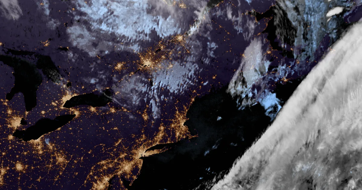
Key points
- Nine National Weather Service offices from Pennsylvania to Down East Maine issued Frost Advisories for tonight into Wednesday morning, and three of them issued Freeze Warnings. NWS New York and NWS Gray call it the coldest night or the coldest air mass of the season so far.
- Inland Connecticut is under Frost Advisories from three offices: Litchfield County from Albany, Hartford, Tolland and Windham from Boston, and the northern parts of Fairfield, New Haven, Middlesex and New London from New York. The forecast lows run from 31 to 36. The shoreline is not included.
- The coldest forecast is 25 degrees in Androscoggin and interior Cumberland counties in Maine. Franklin and Hampshire counties in Massachusetts are forecast at 26 to 32. Boston's office expects highs well into the 60s on Wednesday and a much milder Wednesday night.
Today, officially: a clear, calm night under high pressure
High pressure is settling over the Northeast tonight. Under it the sky clears and the wind goes calm, and the ground gives its heat straight back to space. In its 2:04 p.m. EDT discussion, NWS Boston said this "will result in good radiational cooling and unseasonably chilly temps tonight," with lows "well down into the 30s in many locations with even some upper 20s in the normally coolest low-lying areas of western MA." NWS Albany said its forecast soundings show "a very clear-cut sign of decoupling which will allow winds to go calm."
NWS New York opened its 2:46 p.m. discussion with "Coldest night of the season thus far," and NWS Gray opened with "Coldest air mass of the season so far." Gray issued Freeze Warnings for Androscoggin and interior Cumberland counties because, in its words, those places are "most likely to see below freezing temperatures due to exceptionally calm winds." It said low temperatures "could fall near freezing even along the coast."
The cities are the exception. Boston's office says the mildest spot will be downtown Boston, where lows will only reach the middle 40s. New York's office expects the northern tier to have the best chance of widespread frost.
The advisories cover places where the growing season is still underway. Albany's discussion names the Upper Hudson Valley, the Capital District, the mid-Hudson Valley, the southern Taconics and Litchfield County. Every product carries the same plain advice: "Take steps now to protect tender plants from the cold." The three Freeze Warnings add that the cold could "possibly damage unprotected outdoor plumbing."
| Product | Office, sent | Area | Forecast low, per the product | Runs |
|---|---|---|---|---|
| Freeze Warning | Gray ME, 1:12 p.m. EDT | Androscoggin; Central Interior Cumberland (ME) | as low as 25F | midnight to 8 a.m. Wed |
| Freeze Warning | Boston/Norton MA, 12:56 p.m. EDT | Franklin and Hampshire counties (MA) | 26 to 32 | 11 p.m. to 9 a.m. Wed |
| Freeze Warning | Albany NY, 12:44 p.m. EDT | Northern Saratoga, Northern and Southern Washington, Southeast Warren (NY) | at or below 32 | midnight to 8 a.m. Wed |
| Frost Advisory | Albany NY, 12:44 p.m. EDT | Northern and Southern Litchfield (CT); Capital District, mid-Hudson Valley, Dutchess, Columbia, Ulster, Greene (NY) | 33 to 36 | midnight to 8 a.m. Wed |
| Frost Advisory | Boston/Norton MA, 12:56 p.m. EDT | Hartford, Tolland, Windham (CT); central, western and southeastern MA; Northwest Providence, Western Kent, Washington (RI) | 31 to 36 | 11 p.m. to 9 a.m. Wed |
| Frost Advisory | New York NY, 2:40 p.m. EDT | Northern Fairfield, Northern New Haven, Northern Middlesex, Northern New London (CT); Orange, Putnam (NY) | as low as 32 | 11 p.m. to 9 a.m. Wed |
| Frost Advisory | Gray ME, 1:12 p.m. EDT | south-central and southwest Maine; central and southern New Hampshire | as low as 31F | midnight to 8 a.m. Wed |
| Frost Advisory | Burlington VT, 1:57 p.m. EDT | the Champlain Valley (VT and NY) | as low as 33 | midnight to 7 a.m. Wed |
| Frost Advisory | Caribou ME, 1:52 p.m. EDT | Hancock and Washington counties, coastal and interior (ME) | as low as 33 inland, 35 on the coast | 2 a.m. to 8 a.m. Wed |
| Frost Advisory | Mount Holly NJ, 1:48 p.m. EDT | Sussex (NJ); Carbon, Monroe (PA) | as low as 33 | 11 p.m. to 9 a.m. Wed |
| Frost Advisory | Binghamton NY, 1:13 p.m. EDT | Susquehanna, Wayne, Pike (PA) | as low as 36 | 11 p.m. to 9 a.m. Wed |
| Frost Advisory | State College PA, 1:06 p.m. EDT | Union, Snyder, Montour, Northumberland, Columbia, Schuylkill (PA) | mid 30s | 11 p.m. to 9 a.m. Wed |
*Sources: NWS alert products as listed, read from api.weather.gov at 19:0xZ on 6 October 2026. Area Forecast Discussions: Boston/Norton 2:04 p.m. EDT, Albany 2:02 p.m. EDT, New York 2:46 p.m. EDT, Gray 2:36 p.m. EDT. Forecast lows are each office's own. Frost can form when the air a few feet up reads in the middle 30s.*
After tonight
It does not last long. Boston's office expects Wednesday to be sunny and breezy, with highs "well into the 60s," and Wednesday night to be "much milder," with lows mostly in the upper 40s to lower 50s. Gray expects warmer weather Wednesday and "especially Thursday," with a cold front that may bring a few showers. Boston says an early look at the holiday weekend favors dry weather, though "late Sunday into Monday bears watching for rain."
This is a summary, not emergency information. For live warnings see weather.gov and your local officials. The offices post their products at https://www.weather.gov/box/, https://www.weather.gov/aly/, https://www.weather.gov/okx/, https://www.weather.gov/gyx/, https://www.weather.gov/btv/, https://www.weather.gov/car/, https://www.weather.gov/phi/, https://www.weather.gov/bgm/ and https://www.weather.gov/ctp/.
The rock's live forecast for the places in this story
More from the Journal

Follow the Journal: RSS · get it by email