THE WEATHER BEAT · OCT 6
Downtown Los Angeles hits a record 104, its fourth straight 100-degree day, as heat watches reach the Coachella Valley
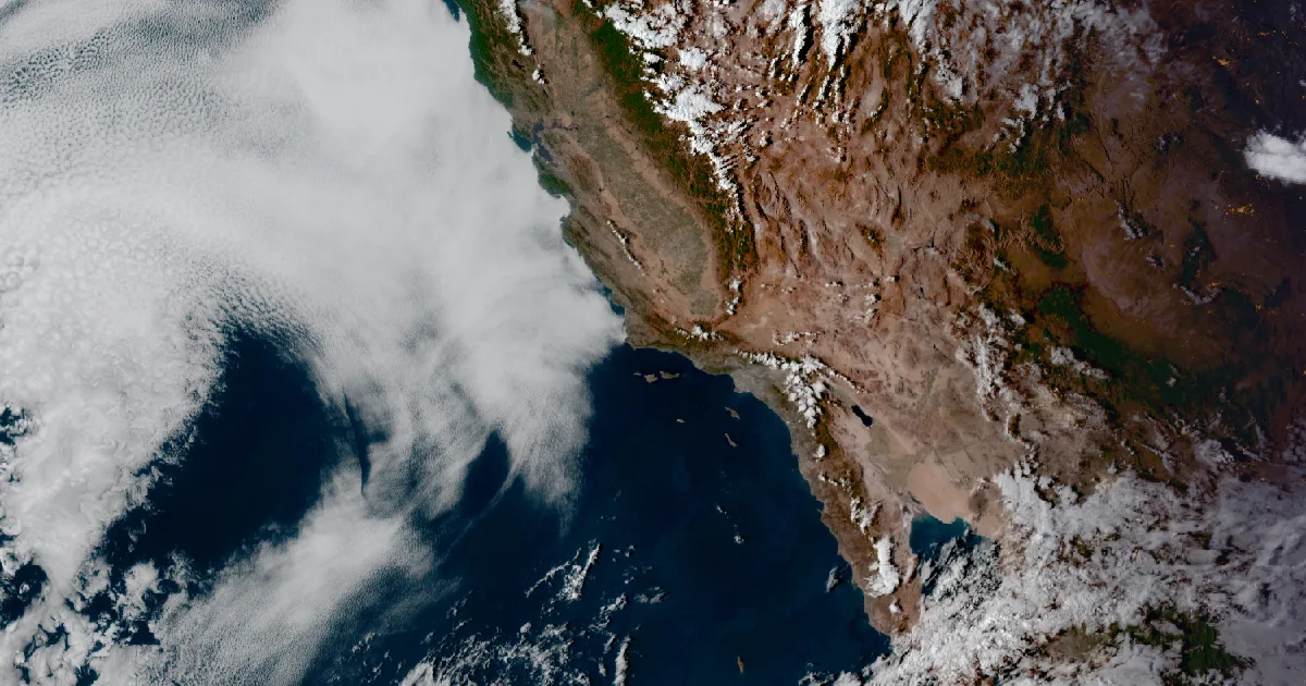
Seven Los Angeles-area sites set or tied records Monday, and new Extreme Heat Watches now cover the Coachella Valley and the lower Colorado River valleys.

Key points
- Downtown Los Angeles reached 104 on Monday, above its old record of 101. NWS Los Angeles/Oxnard says six other sites set or tied records on the same day. It was downtown's fourth straight day at 100 or higher, which the office calls the record for October.
- The heat is moving into the deserts. On Tuesday morning NWS San Diego issued an Extreme Heat Watch for the Coachella Valley, the San Diego County deserts and the San Gorgonio Pass near Banning, with highs possibly as high as 108 on Thursday. NWS Phoenix added a watch for the Parker, Gila River, Palo Verde and Chuckwalla valleys.
- Southern California's Extreme Heat Warnings still run to 8 p.m. PDT Thursday. The Sacramento and San Joaquin Valley Heat Advisories now run to 10 p.m. PDT Friday. Los Angeles/Oxnard expects temperatures to trend cooler each day from Friday into Sunday.
Yesterday: Los Angeles sets records
On Monday, the fourth full day of Southern California's heat warning, the thermometers went past the old marks. In its 2:38 a.m. PDT Tuesday discussion, the Los Angeles/Oxnard office listed seven records from the day. Downtown Los Angeles reached 104, three degrees above its old record of 101. Woodland Hills reached 106, Camarillo 99, and Oxnard 98, which was four degrees above its old mark of 94. Burbank, Long Beach Airport and LAX each tied their records.
The streak matters more than any single number. The office says Monday was downtown's fourth consecutive day at 100 degrees or higher. In its words, "This is the record for October and it looks like that record will be" extended "by 1 maybe two days."
| Site | Monday's high | Old record | Note |
|---|---|---|---|
| Downtown Los Angeles | 104 | 101 | broken; 4th straight day at 100 or higher |
| Woodland Hills | 106 | 105 | broken |
| Burbank | 102 | 102 | tied |
| Long Beach Airport | 104 | 104 | tied |
| LAX | 101 | 101 | tied |
| Camarillo | 99 | 98 | broken |
| Oxnard | 98 | 94 | broken |
*Source: NWS Los Angeles/Oxnard Area Forecast Discussion, 2:38 a.m. PDT Tuesday 6 October 2026, as written by the office. These numbers are preliminary until the office's climate reports confirm them.*
Today, officially: the deserts take their turn
On Sunday this desk reported Extreme Heat Watches for the Imperial Valley and Yuma. Two days later the watches are longer and they cover more ground. NWS San Diego's new watch covers the Coachella Valley, the San Diego County deserts and the San Gorgonio Pass near Banning from Wednesday morning through Friday evening. It says "high temperatures as high as 108 on Thursday possible" and nights in the mid 70s to lower 80s. NWS Phoenix extended its Imperial Valley and Yuma watch from Thursday evening to Friday evening, and it now forecasts 104 to 108 at Yuma. It also added a Thursday-only watch for the Parker and Gila River valleys in Arizona and the Palo Verde and Chuckwalla valleys in California, with 103 to 106. Phoenix's 3:59 a.m. MST discussion says temperatures will warm "to near record levels."
Along the coast the warning stands, with a small change. Los Angeles/Oxnard expects 2 to 4 degrees of cooling on Wednesday for the coast and valleys south of Point Conception as the afternoon sea breeze returns. It expects another 2 to 4 degrees on Thursday, which would bring valley highs to 98 to 102. The office notes those highs would still be 10 to 15 degrees above normal. North of Point Conception it goes the other way: the Central Coast is forecast to warm 3 to 5 degrees on Wednesday, and a new Heat Advisory covers the San Luis Obispo and Santa Barbara central coast beaches on Wednesday and Thursday.
Farther north, the Sacramento and Hanford advisories now run to 10 p.m. PDT Friday instead of Wednesday. The Bay Area and Mendocino and Lake county advisories run to 10 p.m. Thursday.
| Product | Office, sent | Area | Forecast, per the product | Runs until |
|---|---|---|---|---|
| Extreme Heat Warning | Los Angeles/Oxnard, 2:56 a.m. PDT Tue | Los Angeles and Ventura coast and valleys, Santa Clarita, Catalina | 90 to 100 at the coast, 106 in the valleys | 8 p.m. PDT Thu 8 Oct |
| Extreme Heat Warning | Los Angeles/Oxnard, 2:56 a.m. PDT Tue | Santa Barbara County coasts and mountains, Cuyama Valley | up to 85 at the coast, 100 in the mountains | 8 p.m. PDT Thu 8 Oct |
| Extreme Heat Warning | San Diego, 2:20 a.m. PDT Tue | Inland Empire; San Diego County valleys | upper 90s to 105 | 8 p.m. PDT Thu 8 Oct |
| Extreme Heat Warning | San Diego, 2:20 a.m. PDT Tue | Orange County inland and coast; San Diego County coast; Santa Ana Mountains | mid 80s at the beaches to 103 inland | 8 p.m. PDT Thu 8 Oct |
| Extreme Heat Warning | Las Vegas, 2:25 a.m. PDT Tue | Death Valley National Park below 2,000 ft | near 110; lows around 85 | 8 p.m. PDT Fri 9 Oct |
| Extreme Heat Watch (new) | San Diego, 2:20 a.m. PDT Tue | Coachella Valley, San Diego County deserts, San Gorgonio Pass | as high as 108 Thursday; lows mid 70s to low 80s | Wed morning to Fri evening |
| Extreme Heat Watch | Phoenix, 11:41 p.m. MST Mon | Imperial Valley, Imperial County West; Yuma | 104 to 110 / 104 to 108 | Wed morning to Fri evening |
| Extreme Heat Watch (new) | Phoenix, 11:41 p.m. MST Mon | Parker, Gila River, Palo Verde, Chuckwalla valleys | 103 to 106 | Thursday |
| Heat Advisory | Sacramento, 9:42 a.m. PDT Mon | Sacramento Valley, Delta, northern San Joaquin Valley, foothills | 94 to 102 | 10 p.m. PDT Fri 9 Oct |
| Heat Advisory | Hanford, 10:15 a.m. PDT Mon | San Joaquin Valley, Sierra foothills | up to 102 | 10 p.m. PDT Fri 9 Oct |
| Heat Advisory | San Francisco, 2:26 a.m. PDT Tue | East Bay, Santa Clara Valley, North Bay, interior Monterey | mid 90s to near 105 | 10 p.m. PDT Thu 8 Oct |
| Heat Advisory | Eureka, 4:46 a.m. PDT Tue | interior Mendocino, Lake County | 95 to 105 | 10 p.m. PDT Thu 8 Oct |
| Heat Advisory | Los Angeles/Oxnard, 2:56 a.m. PDT Tue | San Luis Obispo and Santa Barbara central coast, inland and beaches | 80 to 95 at the beaches, up to 103 inland | 8 p.m. PDT Thu 8 Oct |
*Sources: NWS alert products as listed, read from api.weather.gov at 12:1xZ on 6 October 2026. Area Forecast Discussions: Los Angeles/Oxnard 2:38 a.m. PDT, Phoenix 3:59 a.m. MST. Forecast figures are each office's own.*
The offices agree on how this ends. Los Angeles/Oxnard expects a "more pronounced cooling trend" by Saturday as high pressure weakens, with a small chance of showers and thunderstorms from the moisture of Hurricane Rachel. Phoenix expects "a potential cooler and more unsettled weather pattern" Sunday into early next week.
This is a morning summary, not emergency information. For live warnings see weather.gov and your local officials. The offices post their products at https://www.weather.gov/lox/, https://www.weather.gov/sgx/, https://www.weather.gov/psr/, https://www.weather.gov/vef/, https://www.weather.gov/sto/ and https://www.weather.gov/hnx/.
The rock's live forecast for the places in this story
More from the Journal
 THE WEATHER BEAT
Flash flood warnings in Louisiana Sunday morning, and Flood Watches from Mobile to south Georgia through Monday
OCT 4
THE WEATHER BEAT
Flash flood warnings in Louisiana Sunday morning, and Flood Watches from Mobile to south Georgia through Monday
OCT 4
 THE WEATHER BEAT
California's heat spreads north and east: Central Valley and Bay Area advisories, a Death Valley warning and an Imperial Valley watch
OCT 4
THE WEATHER BEAT
California's heat spreads north and east: Central Valley and Bay Area advisories, a Death Valley warning and an Imperial Valley watch
OCT 4
 EXPLAINERS
Why Is the Sky Blue?
AUG 20
EXPLAINERS
Why Is the Sky Blue?
AUG 20
Follow the Journal: RSS · get it by email