THE WEATHER BEAT · OCT 4
California's heat spreads north and east: Central Valley and Bay Area advisories, a Death Valley warning and an Imperial Valley watch
Heat Advisories now cover the Sacramento and San Joaquin valleys and the Bay Area, beside Southern California's warning and a new Death Valley warning.

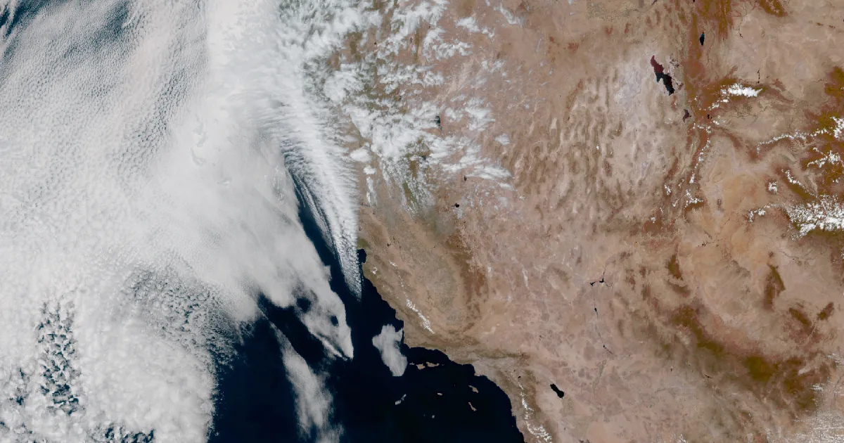
Key points
- Southern California's Extreme Heat Warning still runs to 8 p.m. PDT Thursday. On Sunday afternoon the heat also brought Heat Advisories across the Sacramento and San Joaquin valleys, the Bay Area and southern Mendocino and Lake counties, with highs up to 104 in the southern San Joaquin Valley.
- NWS Las Vegas issued an Extreme Heat Warning for the low country of Death Valley National Park. It forecasts highs near 110 and lows around 85 through 8 p.m. PDT Friday. NWS Phoenix posted an Extreme Heat Watch for the Imperial Valley and Yuma for Wednesday and Thursday, with highs of 104 to 110.
- Four offices wrote about records in their Sunday discussions. Los Angeles/Oxnard expects a few daily records may fall each day through Thursday. Sacramento sees potential for record or near-record highs Monday through Wednesday. Phoenix expects highs near daily records at El Centro and Yuma on Wednesday and Thursday. No record has been reported yet.
Today, officially: the heat goes north and east
On Friday this desk reported that Southern California's heat watch had become a seven-day warning. Two days in, the warning is unchanged, and the heat now reaches past it. By Sunday afternoon, eight National Weather Service offices from Eureka to Phoenix had a heat product up. They cover most of California's populated valleys and two desert corners on the Arizona line.
The biggest move is in the Central Valley. NWS Sacramento issued a Heat Advisory at 1:16 p.m. PDT. It forecasts highs of 94 to 102 from Redding down through Sacramento, Stockton and Modesto, until 10 p.m. Wednesday. Ten minutes later NWS Hanford issued its own advisory, with highs up to 104 and the hottest air in the southern San Joaquin Valley around Bakersfield. That one runs until 11 p.m. Wednesday. In its afternoon discussion, Sacramento says the heat "will only increase as we move into Monday, Tuesday, and Wednesday" and that "potential is there for at or near record highs Monday through Wednesday." The Bay Area advisory from NWS San Francisco runs through Wednesday for the East Bay, the Santa Clara Valley including San Jose, and the interior hills, with highs in the mid 90s to low 100s.
In the south, the Los Angeles/Oxnard office raised its coastal figure on Sunday morning. Friday's warning said up to 90 at the coast and 105 in the valleys. Sunday's says 90 to 100 at the coast and 106 in the valleys. Its afternoon discussion calls this "a major and long lasting heat wave," puts many valleys and coasts south of Point Conception 15 to 27 degrees above normal, and says a few daily temperature records may be broken each day through Thursday. The office expects a small cooling trend at the immediate Los Angeles and Ventura coast as the sea breeze picks up. San Diego's figures barely changed: highs up to 103 in the inland valleys and inland Orange County, up to 105 in the Inland Empire, and nights mostly in the 70s.
The deserts are the new part. Las Vegas has warned for Death Valley below 2,000 feet: highs near 110, with lows "only falling into the mid-80s, offering limited relief from the heat overnight." The office notes that most of its region stays at minor to moderate heat risk. Death Valley is the exception. Phoenix's watch for the Imperial Valley and Yuma runs from Wednesday morning through Thursday evening. Its discussion says those days will be "near daily records in both El Centro, CA and Yuma, AZ."
There is an end in sight, and the offices describe it in much the same way. Los Angeles/Oxnard expects temperatures to trend cooler each day from Friday into Sunday, with a small chance of showers and thunderstorms from the moisture of distant Hurricane Rachel. Las Vegas expects a Pacific trough to bring "a noticeable cooldown" next weekend. Sacramento says confidence "is increasing for a cooling trend late next weekend." The Santa Barbara County warning text still says the heat could run into the second week of October and may need an extension, so the offices do not yet agree on exactly when it ends.
| Product | Office, sent | Area | Forecast, per the product | Runs until |
|---|---|---|---|---|
| Extreme Heat Warning | Los Angeles/Oxnard, 11:04 a.m. PDT | Los Angeles and Ventura coast and valleys, Santa Clarita, Catalina | 90 to 100 at the coast, 106 in the valleys | 8 p.m. PDT Thu 8 Oct |
| Extreme Heat Warning | Los Angeles/Oxnard, 11:04 a.m. PDT | Santa Barbara County coasts and mountains, Cuyama Valley | up to 85 at the coast, 100 in the mountains | 8 p.m. PDT Thu 8 Oct |
| Extreme Heat Warning | San Diego, 11:32 a.m. PDT | Inland Empire | upper 90s to 105; lows low to mid 70s | 8 p.m. PDT Thu 8 Oct |
| Extreme Heat Warning | San Diego, 11:32 a.m. PDT | San Diego County valleys; Orange County inland | upper 90s to 103 / mid 90s to 103; lows in the 70s | 8 p.m. PDT Thu 8 Oct |
| Extreme Heat Warning | San Diego, 11:32 a.m. PDT | San Diego and Orange County coasts | mid 80s to mid 90s at the beaches, up to the low 100s on the mesas | 8 p.m. PDT Thu 8 Oct |
| Extreme Heat Warning | Las Vegas, 12:33 p.m. PDT | Death Valley National Park below 2,000 ft | near 110; lows around 85 | 8 p.m. PDT Fri 9 Oct |
| Extreme Heat Watch | Phoenix, 11:38 a.m. MST | Imperial Valley, Imperial County West; Yuma | 104 to 110 / 104 to 107 | Wed morning to Thu evening |
| Heat Advisory | Hanford, 1:27 p.m. PDT | San Joaquin Valley (Fresno, Visalia, Bakersfield), Sierra foothills | up to 104; foothill lows 70 to 75 | 11 p.m. PDT Wed 7 Oct |
| Heat Advisory | Sacramento, 1:16 p.m. PDT | Sacramento Valley, Delta, northern San Joaquin Valley, foothills | 94 to 102; lows mid 60s to low 70s | 10 p.m. PDT Wed 7 Oct |
| Heat Advisory | San Francisco, 7:48 p.m. PDT Sat | East Bay, Santa Clara Valley, interior Monterey and San Benito | mid 90s to low 100s | 10 p.m. PDT Wed 7 Oct |
| Heat Advisory | Eureka, 1:15 p.m. PDT | southern interior Mendocino, southern Lake | up to 101; nights over 65 | 11 p.m. PDT Mon 5 Oct |
| Heat Advisory | Los Angeles/Oxnard, 11:04 a.m. PDT | San Luis Obispo and Santa Barbara inland central coast, Santa Ynez Valley | around 90 near the coast to 103 inland | 8 p.m. PDT Thu 8 Oct |
*Sources: NWS alert products as listed, all sent 4 October 2026 except where marked, read from api.weather.gov at 23:2xZ. Area Forecast Discussions read at the same time: Los Angeles/Oxnard 2:30 p.m. PDT, Sacramento 1:37 p.m. PDT, Las Vegas 3:40 p.m. PDT, Phoenix 2:19 p.m. MST. Record wording is each office's forecast; no record has been reported.*
This is a summary of official warnings, not emergency information. For live warnings see weather.gov and your local officials. The offices post their products at https://www.weather.gov/lox/, https://www.weather.gov/sgx/, https://www.weather.gov/sto/, https://www.weather.gov/hnx/, https://www.weather.gov/vef/ and https://www.weather.gov/psr/.
The rock's live forecast for the places in this story
More from the Journal
 THE WEATHER BEAT
How to read a river forecast: the Missouri at Jefferson City has a crest scheduled four days out
OCT 3
THE WEATHER BEAT
How to read a river forecast: the Missouri at Jefferson City has a crest scheduled four days out
OCT 3
 THE WEATHER BEAT
Southern California's heat watch becomes a warning: seven days of heat from Santa Barbara to San Diego, starting today
OCT 2
THE WEATHER BEAT
Southern California's heat watch becomes a warning: seven days of heat from Santa Barbara to San Diego, starting today
OCT 2
 EXPLAINERS
Why Is the Sky Blue?
AUG 20
EXPLAINERS
Why Is the Sky Blue?
AUG 20
Follow the Journal: RSS · get it by email