THE WEATHER BEAT · OCT 4
Flash flood warnings in Louisiana Sunday morning, and Flood Watches from Mobile to south Georgia through Monday
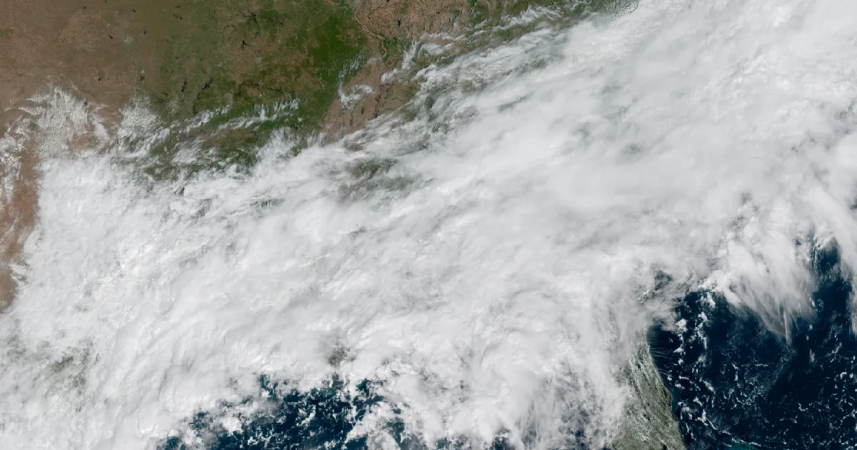
Radar put 3 to 6 inches over northwest Louisiana by 8:42 a.m. Sunday, and Tallahassee's Flood Watch allows up to 10 more inches on the Emerald Coast.

Key points
- Sunday morning the National Weather Service issued Flash Flood Warnings in three parts of Louisiana. In northwest Louisiana, Doppler radar estimated 3 to 6 inches of rain had fallen by 8:42 a.m. CDT.
- Flood Watches run from the Mississippi coast to south Georgia. NWS Tallahassee forecasts 2 to 6 more inches across most of its area through Monday morning, and locally up to 10 inches, especially along the Emerald Coast.
- The Shoal River near Crestview, Florida, is forecast to rise above flood stage Monday evening and crest at 8.9 feet early Tuesday afternoon.
Sunday morning, Louisiana
The rain arrived in northwest Louisiana first. At 8:42 a.m. CDT, NWS Shreveport issued a Flash Flood Warning for parts of six parishes: Bienville, Bossier, Caddo, De Soto, Red River and Webster. Radar estimated that 3 to 6 inches had already fallen there and that 2 to 4 more were possible. The office called the hazard life threatening flash flooding. The warning ran until 12:45 p.m. CDT.
Two hours later the rain had reached the northeast corner of the state. NWS Jackson issued a warning for northern Morehouse Parish at 10:55 a.m. CDT, naming Bastrop, Mer Rouge, Bonita, Galion, Beekman and Jones. Just before noon it reached New Orleans. At 11:47 a.m. CDT, NWS New Orleans warned north central Jefferson Parish and southwestern Orleans Parish, including New Orleans, Gretna and Lakefront Airport. Radar there estimated 1 to 3 inches had fallen, with 1 to 3 more possible.
| Warning | Office, issued | Until | Radar rain so far | More possible |
|---|---|---|---|---|
| Flash Flood, six parishes of northwest Louisiana | Shreveport, 8:42 a.m. CDT | 12:45 p.m. CDT | 3 to 6 in | 2 to 4 in |
| Flash Flood, northern Morehouse Parish | Jackson MS, 10:55 a.m. CDT | 1:00 p.m. CDT | not stated | not stated |
| Flash Flood, Jefferson and Orleans | New Orleans, 11:47 a.m. CDT | 2:45 p.m. CDT | 1 to 3 in | 1 to 3 in |
*Source: NWS Flash Flood Warnings as issued Sunday, October 4. All three figures are the offices' radar estimates, not gauge totals.*
Today and tonight, officially
To the east, Sunday's forecast is a watch, not a warning. At 11:10 a.m. CDT, NWS Mobile's Flood Watch for Mobile and Baldwin counties in Alabama and for Escambia, Santa Rosa and Okaloosa in northwest Florida called for "multiple rounds of heavy rainfall" through the afternoon. It forecast 2 to 4 more inches, and locally up to 6. The watch runs through this evening.
NWS Tallahassee has the largest numbers on the coast. Its watch, issued at 2:09 a.m. EDT and in effect until 8 a.m. EDT Monday, covers southeast Alabama, the Florida Big Bend and Panhandle, and southwest Georgia. It forecasts 2 to 6 more inches across most of the area, "with locally higher amounts of up to 10 inches possible, especially along the Emerald Coast." The office singled out south-central Georgia, where heavy rain on "the past two afternoons has primed the region," and said the tropical air mass in place could bring "very high rain rates."
Rivers respond more slowly. At 10:19 a.m. CDT, NWS Mobile extended its Flood Warning for the Shoal River near Crestview. The river stood at 4.9 feet at 9:15 a.m. Sunday. It is forecast to pass its 8.0-foot flood stage Monday evening, crest at 8.9 feet early Tuesday afternoon and fall back below flood stage late Thursday evening. The office says that at 8.5 feet, water reaches yards on Sowel Road.
The Storm Prediction Center's day 1 outlook, as read at 1:43 p.m. EDT, puts the same corner of the coast at its lowest category, marginal: "A few rotating thunderstorms are possible today across parts of the Florida Panhandle/far southern Alabama."
| Product | Office, issued | In effect until | What it says |
|---|---|---|---|
| Flood Watch, SW Alabama and NW Florida | Mobile, 11:10 a.m. CDT | midnight CDT tonight | 2 to 4 in more, locally 6 |
| Flood Watch, SE Alabama, Big Bend, SW Georgia | Tallahassee, 2:09 a.m. EDT | 8 a.m. EDT Monday | 2 to 6 in more, locally 10 |
| Flood Warning, Shoal River near Crestview | Mobile, 10:19 a.m. CDT | 4 a.m. CDT Oct 9 | crest 8.9 ft early Tue, flood stage 8.0 ft |
| SPC day 1 outlook | Storm Prediction Center | today | marginal, Florida Panhandle and far southern Alabama |
*Source: NWS Mobile and Tallahassee products and the SPC day 1 outlook, all as read at 17:43Z October 4. SPC preliminary storm reports and the WPC excessive rainfall outlook did not load for this desk today, so neither is cited.*
A watch means the ingredients are in place and the office is watching. A warning means flooding has started or is about to. The Weather School's lesson on watches, warnings and advisories explains the difference.
This is a morning summary, not emergency information. For live warnings see weather.gov and your local officials, and for river forecasts see water.noaa.gov.
The rock's live forecast for the places in this story
More from the Journal
 THE WEATHER BEAT
Southern California's heat watch becomes a warning: seven days of heat from Santa Barbara to San Diego, starting today
OCT 2
THE WEATHER BEAT
Southern California's heat watch becomes a warning: seven days of heat from Santa Barbara to San Diego, starting today
OCT 2
 THE WEATHER BEAT
The Plains rain reaches the Missouri River: Glasgow forecast for moderate flooding Monday as Nebraska crests come down
OCT 2
THE WEATHER BEAT
The Plains rain reaches the Missouri River: Glasgow forecast for moderate flooding Monday as Nebraska crests come down
OCT 2
 EXPLAINERS
Why Is the Sky Blue?
AUG 20
EXPLAINERS
Why Is the Sky Blue?
AUG 20
Follow the Journal: RSS · get it by email