THE WEATHER BEAT · OCT 8
Isaias becomes a hurricane overnight as warnings go up from Ocean Springs to Panama City Beach
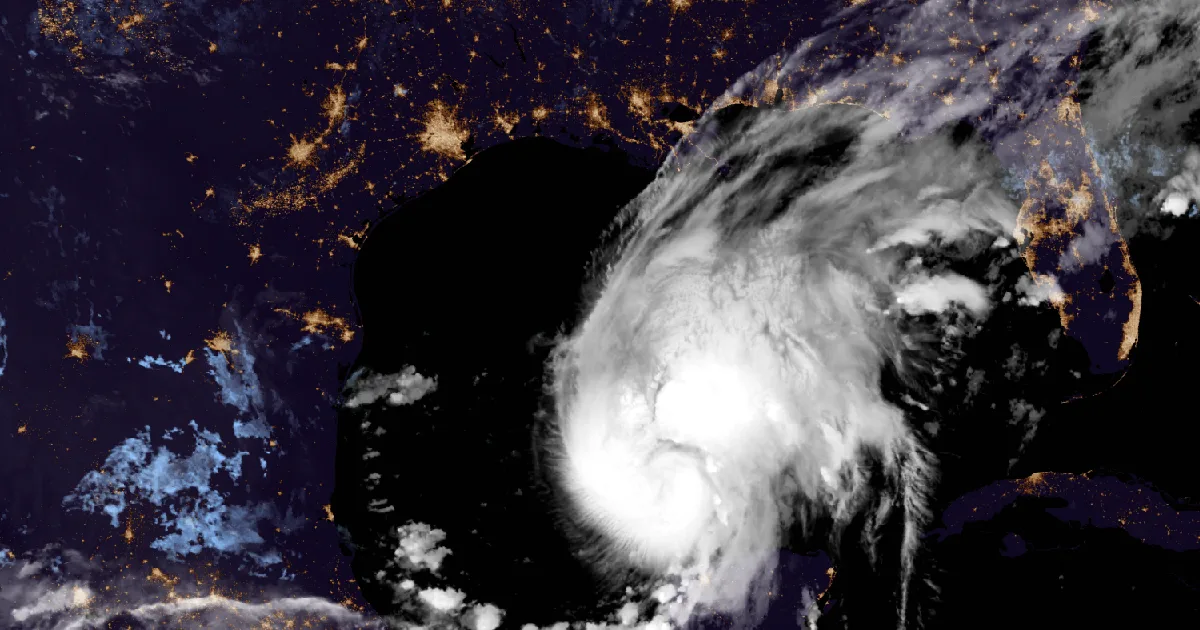
Isaias reached 80 mph by 4 a.m. CDT Thursday. Hurricane and Storm Surge Warnings now cover the coast from Mississippi to the Big Bend, with landfall late.

Key points
- Isaias became a hurricane at about 10:30 p.m. CDT Wednesday. By 4 a.m. CDT Thursday the National Hurricane Center put its top winds near 80 mph, with the pressure down to 979 millibars from 994 at Wednesday's 7 p.m. advisory.
- The watches became warnings overnight. A Hurricane Warning runs from Ocean Springs, Mississippi, to the Bay/Gulf County Line in Florida. A Storm Surge Warning runs from the mouth of the Mississippi River to the Steinhatchee River, Florida, with 5 to 7 feet possible from Ocean Springs to Indian Pass and in Mobile Bay.
- The Center still expects landfall within the warning area late Friday or early Saturday. Its 4 a.m. forecast has a peak near 110 mph early Friday and some weakening before landfall. Flood Watches from Mobile and Tallahassee cover Friday afternoon into Saturday, with 3 to 7 inches of rain and local totals up to 10.
Isaias overnight: a hurricane, and the warnings go up
Isaias spent Wednesday night working its way east-northeast across the southern Gulf, and the hurricane hunters never left it. At 10 p.m. CDT the Hurricane Center had it at 70 mph and 988 millibars. Right after that advisory, an Air Force Reserve crew dropped an instrument into the southwest side of the storm and measured winds strong enough for the Center to call it a hurricane at 10:30 p.m. A NOAA crew took over after that. By 4 a.m. Thursday, Isaias had 80 mph winds and a pressure of 979 millibars. The 4 a.m. headline read: "NOAA Hurricane Hunters indicate that Isaias continues to intensify."
The 10 p.m. advisory turned the watches into warnings. The Hurricane Watch became a Hurricane Warning from Ocean Springs, Mississippi, to the Bay/Gulf County Line in Florida. That stretch covers Mobile Bay, Pensacola, the Okaloosa coast and Panama City. The Storm Surge Watch became a Storm Surge Warning from the mouth of the Mississippi River to the Steinhatchee River. Tropical Storm Warnings went up on both sides, west to the Jefferson/Plaquemines Parish line in Louisiana and east to the Aucilla River in Florida. The 1 a.m. and 4 a.m. advisories changed nothing.
The local offices carried the warnings inland. Mobile's 10:17 p.m. CDT statement extended the Hurricane Warning to inland Mobile, Baldwin, Escambia, Santa Rosa and Okaloosa counties. New Orleans put up Tropical Storm Warnings for inland Hancock, Harrison and Jackson counties in Mississippi, and the Hurricane Watch for northern Jackson County stays in place. At 5:58 a.m. EDT, Tallahassee raised the inland Panhandle from a Tropical Storm Watch to a Tropical Storm Warning, from Walton County east to Liberty, Franklin and Wakulla. Its explanation: the wind field "may be lopsided towards the east, which means impacts are likely well beyond the forecast cone."
The 4 a.m. discussion was candid about the intensity forecast. It called it "somewhat tricky": Isaias has been strengthening through about 20 knots of wind shear, and "an eyewall keeps coming and going in aircraft fixes." The Center brings it to "just shy of major hurricane intensity" in 24 hours. It then expects shear to rise to 40 to 50 knots in the last day before landfall, which "will likely impart some weakening." Its next line: "Isaias is expected to remain a dangerous hurricane through landfall."
Rain is the part that reaches farthest. Tallahassee's 2:38 a.m. EDT Flood Watch covers southeast Alabama, the Florida Panhandle and Big Bend, and southwest Georgia from Friday afternoon through Saturday evening, with "widespread totals of 3 to 7 inches" and local 10-inch amounts. Its storm statement adds that "soggy conditions across the region from recent rainfall" leave the ground more sensitive to flooding. Mobile's Flood Watch covers the Alabama coast and the western Panhandle from Friday afternoon through Saturday afternoon. The Center also lists isolated tornadoes as possible Friday night near the coast of Alabama, the Florida Panhandle and far southwest Georgia, and on Saturday farther inland.
At 4 a.m., Isaias sat about 540 miles south-southwest of Mobile, about 580 miles southwest of Panama City and about 460 miles south of New Orleans.
| Item | 7 p.m. CDT Wed (Adv 5A) | 10 p.m. CDT Wed (Adv 6) | 1 a.m. CDT Thu (Adv 6A) | 4 a.m. CDT Thu (Adv 7) |
|---|---|---|---|---|
| Center | 22.8N 92.4W | 22.9N 91.9W | 23.1N 91.7W | 23.3N 91.2W |
| Distance | About 480 mi SSW of the mouth of the Mississippi | About 460 mi SSW | About 445 mi SSW | About 420 mi SSW |
| Max sustained winds | 65 mph | 70 mph | 75 mph | 80 mph |
| Pressure | 994 mb | 988 mb | 981 mb | 979 mb (28.91 in) |
| Movement | ENE, 8 mph | ENE, 9 mph | ENE, 9 mph | ENE, 9 mph |
| Hurricane-force wind radius | none | none | not stated | Up to 15 mi |
| Tropical-storm-force wind radius | Up to 60 mi | not quoted here | not quoted here | Up to 90 mi |
| NHC forecast point (Discussion 7, 4 a.m. CDT Thu) | Position | Max winds |
|---|---|---|
| Thu 1 p.m. CDT | 24.2N 90.0W | 100 mph |
| Fri 1 a.m. CDT | 25.9N 88.6W | 110 mph |
| Fri 1 p.m. CDT | 28.4N 87.6W | 105 mph |
| Sat 1 a.m. CDT | 31.0N 87.6W, inland | 65 mph |
| Sat 1 p.m. CDT | 33.7N 88.5W, post-tropical, inland | 35 mph |
| Peak surge if it arrives at high tide (Adv 7) | Height above ground |
|---|---|
| Ocean Springs, MS to Indian Pass, FL | 5 to 7 ft |
| Mobile Bay | 5 to 7 ft |
| Indian Pass to Steinhatchee River, FL | 4 to 6 ft |
| Mouth of the Mississippi River to Ocean Springs, MS | 3 to 5 ft |
| Steinhatchee River to Yankeetown, FL | 2 to 4 ft |
| Lake Pontchartrain | 1 to 3 ft |
| Office | Statement | What changed overnight |
|---|---|---|
| NWS Mobile | 10:17 p.m. CDT Wed | Hurricane Watch to Hurricane Warning, Storm Surge Watch to Storm Surge Warning: Baldwin, Mobile, Escambia, Santa Rosa and Okaloosa coastal and central zones. Hurricane Warning: those five counties' inland zones. Hurricane Watch stays for Conecuh, Covington, Escambia AL |
| NWS New Orleans | 10:15 p.m. CDT Wed | Hurricane Warning and Storm Surge Warning: Southern Jackson. Storm Surge and Tropical Storm Warnings: Southern Harrison, Southern Hancock, Eastern Orleans, Lower Plaquemines, Lower St. Bernard, Southeast St. Tammany. Tropical Storm Warning: Northern Hancock, Northern Harrison, Northern Jackson |
| NWS Tallahassee | 11:14 p.m. EDT Wed and 5:58 a.m. EDT Thu | Hurricane and Storm Surge Warnings: Coastal Bay, South Walton. Storm Surge and Tropical Storm Warnings: Coastal Gulf, Franklin, Wakulla, Jefferson. Storm Surge Warning: Coastal Taylor. At 5:58 a.m., Tropical Storm Warning for 12 inland zones from Walton to Wakulla |
| NWS Tampa Bay | 5:37 a.m. EDT Thu | None. Storm Surge Watch for Coastal Levy, up to 4 ft |
*Sources: National Hurricane Center Isaias Intermediate Advisory 5A (7 p.m. CDT Wed), Advisory 6 (10 p.m. CDT Wed), Intermediate Advisory 6A (1 a.m. CDT Thu), Advisory 7 and Discussion 7 (4 a.m. CDT Thu); NWS Tropical Cyclone Local Statements from Mobile, New Orleans, Tallahassee and Tampa Bay; NWS Flood Watches from Tallahassee (2:38 a.m. EDT) and Mobile (1:37 a.m. CDT). Forecast times are converted from UTC. This is a forecast, not a measurement.*
What the offices ask of people in the warning
The Hurricane Center's 4 a.m. advisory asks that preparations along the warning coast "be rushed to completion today." Its key messages ask residents of the Storm Surge Warning to "follow advice given by local officials and evacuate if told to do so," and people in the Hurricane Warning to "prepare for the possibility of long-duration power outages." Tallahassee says conditions on the Panhandle "could begin to deteriorate" as early as Friday morning. The federal preparedness guide is at https://www.ready.gov/hurricanes.
This is a morning summary, not emergency information. For live warnings see weather.gov and your local officials. The National Hurricane Center: https://www.nhc.noaa.gov/
The rock's live forecast for the places in this story
More from the Journal
 THE WEATHER BEAT
Frost Advisories from Pennsylvania to Maine and across inland Connecticut for the season's coldest night so far
OCT 6
THE WEATHER BEAT
Frost Advisories from Pennsylvania to Maine and across inland Connecticut for the season's coldest night so far
OCT 6
 THE WEATHER BEAT
Flash flood warnings overnight from Destin to Dothan and southwest Georgia, with Flood Watches until Monday evening
OCT 5
THE WEATHER BEAT
Flash flood warnings overnight from Destin to Dothan and southwest Georgia, with Flood Watches until Monday evening
OCT 5
 EXPLAINERS
Why Is the Sky Blue?
AUG 20
EXPLAINERS
Why Is the Sky Blue?
AUG 20
Follow the Journal: RSS · get it by email