THE WEATHER BEAT · OCT 8
Isaias reaches 100 mph with the season's first eye as Montgomery and inland Walton County move under warnings
Isaias reached 100 mph Thursday afternoon. By evening, warnings had reached central Alabama and inland Walton County, Florida, and the core rain forecast.

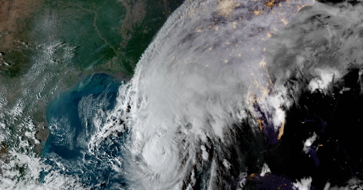
Key points
- Hurricane Hunters found Isaias at 100 mph Thursday afternoon. At 7 p.m. CDT it was 290 miles south of the mouth of the Mississippi River, moving northeast at 13 mph. The National Hurricane Center expects it to peak near 110 mph early Friday and make landfall inside the warning area late Friday or early Saturday.
- The inland watches started turning into warnings. Birmingham raised 10 central Alabama counties, Montgomery among them, from a Tropical Storm Watch to a Tropical Storm Warning. Tallahassee extended the Hurricane Warning inland across Walton County, Florida. Jackson put 10 east Mississippi counties under a Tropical Storm Watch.
- The rain forecast for the core went up again. Southern Alabama, the Florida Panhandle and Big Bend, and southwest Georgia are now in for 4 to 8 inches, up from 3 to 7 in the morning advisory, with local totals up to 15. The coastal Carolinas now have their own line: 3 to 5 inches, locally 8.
Isaias Thursday evening: 100 mph, and the first eye of the season
Isaias kept strengthening through Thursday afternoon. At 4 p.m. CDT the Center raised the winds from 85 mph to 100 mph. The surface winds measured by the Hurricane Hunter aircraft's tail radar supported the increase, even though, as the discussion noted, the pressure had not dropped yet and the flight-level winds had not risen. The same discussion recorded something new: "this is the first eye noted on satellite pictures in the Atlantic basin during the 2026 Hurricane Season."
The storm also made the turn the Center had forecast. It is now heading northeast, and a turn to the north is expected Friday. The Center called its intensity forecast "somewhat problematic." The hurricane will cross warm Gulf water tonight, with a warm eddy along the track, so the forecast brings it to 110 mph by 1 a.m. CDT Friday. By Friday afternoon, stronger shear should knock the peak down to about 100 mph before landfall. The Center's summary line has not changed: "Isaias is expected to remain a dangerous hurricane through landfall."
The 4 p.m. and 7 p.m. advisories changed no coastal watch or warning. The Hurricane Warning still runs from Ocean Springs, Mississippi, to the Bay/Gulf County Line in Florida. The Storm Surge Warning runs from the mouth of the Mississippi River to the Suwannee River, and the forecast still calls for 5 to 7 feet from Ocean Springs to Indian Pass and in Mobile Bay. The hurricane-force winds reach 15 miles from the center, and tropical-storm-force winds reach 125 miles.
| Item | 1 p.m. CDT (Adv 8A, this afternoon's story) | 4 p.m. CDT (Adv 9) | 7 p.m. CDT (Adv 9A) |
|---|---|---|---|
| Center | 24.0N 89.8W | 24.4N 89.3W | 24.9N 88.8W |
| Distance | About 355 mi S of the mouth of the Mississippi | About 325 mi S | About 290 mi S |
| Max sustained winds | 85 mph | 100 mph | 100 mph |
| Pressure | 975 mb | 975 mb | 974 mb (28.77 in) |
| Movement | ENE, 10 mph | NE, 12 mph | NE, 13 mph |
| Coastal change | none | none | none |
| NHC forecast point (Discussion 9, 4 p.m. CDT Thu) | Position | Max winds |
|---|---|---|
| Fri 1 a.m. CDT | 25.7N 88.4W | 110 mph |
| Fri 1 p.m. CDT | 28.2N 87.4W | 100 mph |
| Sat 1 a.m. CDT | 31.0N 87.2W, inland | 75 mph |
| Sat 1 p.m. CDT | 33.2N 87.8W, inland | 35 mph |
| Sun 1 a.m. CDT | 35.0N 87.8W, post-tropical, inland | 30 mph |
| Sun 1 p.m. CDT | 37.0N 85.0W, post-tropical, inland | 25 mph |
| Mon 1 p.m. CDT | dissipated |
*Sources: National Hurricane Center Isaias Intermediate Advisory 8A (1 p.m. CDT), Advisory 9 and Discussion 9 (4 p.m. CDT), Intermediate Advisory 9A (7 p.m. CDT Thu). Forecast times are converted from UTC. These are forecasts, not measurements.*
Inland: watches become warnings
This afternoon's story ended with the inland offices putting up watches. By early evening some of them were warnings.
- Birmingham's 4:15 p.m. CDT statement upgraded the Tropical Storm Watch to a Tropical Storm Warning for Autauga, Barbour, Bullock, Dallas, Elmore, Lowndes, Macon, Marengo, Montgomery and Pike counties. Nineteen more counties, including Jefferson (Birmingham) and Tuscaloosa, stay under the watch. By 7:18 p.m. the office was calling for gusts "as high as 50 to 60+ mph late Friday night through Saturday" and warned of "the potential for widespread downed trees and power lines." At 1:07 p.m. it had said 40 to 50 mph with isolated 60.
- Tallahassee's 5:35 p.m. EDT statement upgraded Central and North Walton County, Florida, to a Hurricane Warning, which carries the warning inland from the coast.
- Jackson, Mississippi, issued a Tropical Storm Watch at 4:18 p.m. CDT for Clarke, Forrest, Jasper, Jones, Kemper, Lauderdale, Neshoba, Newton, Noxubee and Winston counties. Its statement expects landfall "along the Florida Panhandle late Friday evening into early Saturday morning."
- Mobile's 4:16 p.m. CDT statement keeps a Hurricane Watch on top of the Tropical Storm Warning for Conecuh and Covington counties in Alabama. Inland Mobile, Baldwin, Escambia, Okaloosa and Santa Rosa counties are under the Hurricane Warning.
In its 4 p.m. discussion the Center said more Tropical Storm and High Wind Watches and Warnings "may be required" for central and northern Alabama, extreme eastern Mississippi and western and northern Georgia "later tonight."
| Office | Change, issue time | Counties |
|---|---|---|
| NWS Birmingham AL | Tropical Storm Watch to Warning, 4:15 p.m. CDT | Autauga, Barbour, Bullock, Dallas, Elmore, Lowndes, Macon, Marengo, Montgomery, Pike |
| NWS Tallahassee FL | Tropical Storm Warning and Hurricane Watch to Hurricane Warning, 5:35 p.m. EDT | Central Walton, North Walton |
| NWS Jackson MS | Tropical Storm Watch issued, 4:18 p.m. CDT | Clarke, Forrest, Jasper, Jones, Kemper, Lauderdale, Neshoba, Newton, Noxubee, Winston |
| NWS Mobile AL | No change, 4:16 p.m. CDT; Tropical Storm Warning plus Hurricane Watch | Conecuh, Covington |
| NWS Peachtree City GA | No change, 5:26 p.m. EDT; Tropical Storm Watch | 16 west-central Georgia counties, including Muscogee and Troup |
*Sources: NWS Tropical Cyclone Local Statements from Birmingham (4:15 and 7:18 p.m. CDT), Tallahassee (5:35 p.m. EDT), Jackson (4:18 p.m. CDT), Mobile (4:16 p.m. CDT) and Peachtree City (5:26 p.m. EDT); National Hurricane Center Discussion 9.*
The rain
The 4 p.m. advisory raised the main rain range and drew a separate line for the Carolinas:
| Area | Advisory 8 (10 a.m. CDT) | Advisory 9 (4 p.m. CDT) |
|---|---|---|
| Core: far southeast Louisiana to the Big Bend (Adv 8); southern Alabama, Florida Panhandle and Big Bend, southwest Georgia (Adv 9) | 3 to 7 in | 4 to 8 in |
| Localized, mainly Panhandle and Big Bend banding | up to 15 in | up to 15 in |
| Coastal Carolinas | inside the Southeast line, 1 to 3 in | 3 to 5 in, locally 8 |
| Rest of the Southeast | 1 to 3 in, locally 5 | 1 to 3 in, locally 5 |
The Center still expects flash and urban flooding, "with considerable impacts possible across much of southern Alabama and the Florida Panhandle into southwestern Georgia," and river flooding, "some of which could be significant." It says an isolated tornado risk begins Friday night along the Alabama and Panhandle coast and in far southwest Georgia, and moves into eastern Alabama and Georgia on Saturday.
*Source: National Hurricane Center Isaias Advisories 8 and 9. Forecast amounts, not measurements.*
In its 4 p.m. key messages, the Center asks residents of the surge warning area to "follow advice given by local officials and evacuate immediately if told to do so," and asks people under the Hurricane Warning to "prepare for the possibility of long-duration power outages." The 7 p.m. advisory still says preparations "should be rushed to completion in the warning area." The federal preparedness guide is at https://www.ready.gov/hurricanes. This afternoon's story on the inland watches is at /journal/beat/isaias-85-mph-inland-watches-alabama-georgia-tennessee-2026-10-08/.
This is a summary of official warnings, not emergency information. For live warnings see weather.gov and your local officials. The National Hurricane Center: https://www.nhc.noaa.gov/
The rock's live forecast for the places in this story
More from the Journal
 THE WEATHER BEAT
Isaias reaches 65 mph Wednesday evening as Hurricane Watches reach inland Alabama and Tropical Storm Watches spread across 18 more counties
OCT 7
THE WEATHER BEAT
Isaias reaches 65 mph Wednesday evening as Hurricane Watches reach inland Alabama and Tropical Storm Watches spread across 18 more counties
OCT 7
 THE WEATHER BEAT
Downtown Los Angeles hits a record 104, its fourth straight 100-degree day, as heat watches reach the Coachella Valley
OCT 6
THE WEATHER BEAT
Downtown Los Angeles hits a record 104, its fourth straight 100-degree day, as heat watches reach the Coachella Valley
OCT 6
 EXPLAINERS
Why Is the Sky Blue?
AUG 20
EXPLAINERS
Why Is the Sky Blue?
AUG 20
Follow the Journal: RSS · get it by email