THE WEATHER BEAT · OCT 9
Isaias reaches 110 mph overnight with landfall expected tonight, as High Wind Watches stretch to Atlanta and Chattanooga
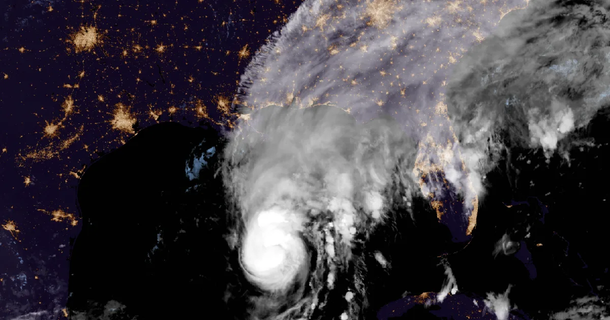
Isaias strengthened to 110 mph overnight and is forecast to peak near 120 mph today before landfall tonight or early Saturday. Its wind field has doubled.

Key points
- Isaias strengthened overnight to 110 mph, with its pressure down to 963 mb. At 4 a.m. CDT it was 200 miles south-southeast of the mouth of the Mississippi River, moving north-northeast at 15 mph. The National Hurricane Center expects landfall inside the Hurricane Warning tonight or early Saturday.
- The Center now forecasts a peak near 120 mph by 1 p.m. CDT today. Discussion 9 had 100 mph for the same hour. It still expects some weakening before landfall and calls its best estimate "a high-end category 2 intensity at landfall."
- The wind field has grown. Hurricane-force winds now reach 30 miles from the center, up from 15, and tropical-storm-force winds reach 185 miles, up from 125. Overnight, High Wind Watches covered north Alabama, Chattanooga and the metro Atlanta counties, and Jackson, Mississippi, added three counties to its Tropical Storm Watch.
Isaias Friday morning: 110 mph and still strengthening
Isaias spent the night over deep, warm Gulf water and used it. The Hurricane Hunters found flight-level winds up to 107 knots, a better-defined eye and a shrinking eyewall, and the Center raised the surface winds to 110 mph in its 4 a.m. CDT advisory. The pressure fell 9 mb in three hours, from 972 to 963. The Center's headline was blunt: "Preparations should be rushed to completion as the weather will go downhill quickly today."
The Center expects Isaias to become a major hurricane this morning. Its forecast still calls for some weakening before landfall, when the wind shear rises. The discussion also explained why that call is shaky: "it would only take about a 6h delay in the onset of the shear to bring a stronger hurricane than expected onshore." It added that, whatever the exact wind speed at landfall, "Isaias will be a dangerous hurricane with significant storm surge, damaging winds, and flooding rains," and that the wind field should grow, so "some of these impacts will extend well away from the center."
The track barely moved. Isaias should turn north and pick up speed today. The forecast puts the center inland near 31.0N 87.1W by 1 a.m. CDT Saturday, which is north of the Alabama and Florida Panhandle coast. No coastal watch or warning changed overnight. The Hurricane Warning still runs from Ocean Springs, Mississippi, to the Bay/Gulf County Line in Florida.
| Item | 7 p.m. CDT Thu (Adv 9A, last night's story) | 10 p.m. CDT Thu (Adv 10) | 1 a.m. CDT Fri (Adv 10A) | 4 a.m. CDT Fri (Adv 11) |
|---|---|---|---|---|
| Center | 24.9N 88.8W | 25.4N 88.4W | 25.8N 88.4W | 26.4N 88.0W |
| Distance from the mouth of the Mississippi | About 290 mi S | About 260 mi S | About 230 mi S | About 200 mi SSE |
| Max sustained winds | 100 mph | 105 mph | 105 mph | 110 mph |
| Pressure | 974 mb | 969 mb | 972 mb | 963 mb (28.44 in) |
| Movement | NE, 13 mph | NE, 14 mph | NNE, 14 mph | NNE, 15 mph |
| Coastal change | none | none | none | none |
| NHC forecast point (Discussion 11, 4 a.m. CDT Fri) | Position | Max winds |
|---|---|---|
| Fri 1 p.m. CDT | 28.4N 87.3W | 120 mph |
| Sat 1 a.m. CDT | 31.0N 87.1W, inland | 75 mph |
| Sat 1 p.m. CDT | 33.5N 87.5W, post-tropical, inland | 40 mph |
| Sun 1 a.m. CDT | 35.5N 86.7W, post-tropical, inland | 30 mph |
| Sun 1 p.m. CDT | 38.2N 83.1W, post-tropical, inland | 15 mph |
| Mon 1 a.m. CDT | dissipated |
| Peak surge if it arrives at high tide (Adv 11) | Height above ground |
|---|---|
| Dauphin Island, AL to Indian Pass, FL | 5 to 7 ft |
| Indian Pass to Steinhatchee River, FL | 4 to 6 ft |
| Steinhatchee River to Suwannee River, FL | 3 to 5 ft |
| Mouth of the Mississippi to Dauphin Island; Mobile Bay | 3 to 5 ft |
| Suwannee River to Yankeetown, FL | 2 to 4 ft |
| Yankeetown to Egmont Key, FL; Lake Pontchartrain | 1 to 3 ft |
| Morgan City to the mouth of the Mississippi, LA | 1 to 2 ft |
*Sources: National Hurricane Center Isaias Intermediate Advisory 9A (7 p.m. CDT Thu), Advisory 10 (10 p.m. CDT Thu), Intermediate Advisory 10A (1 a.m. CDT Fri), Advisory 11 and Discussion 11 (4 a.m. CDT Fri). Forecast times are converted from UTC. These are forecasts, not measurements.*
Inland: the wind watches reach Atlanta and Chattanooga
Overnight, every hurricane statement from the coastal and inland offices read "CHANGES: None" except one. At 4:19 a.m. CDT, Jackson, Mississippi, issued a Tropical Storm Watch for Clay, Lowndes and Oktibbeha counties.
The wider inland reach shows up in a different product. Five High Wind Watches now run from northeast Alabama across north Georgia into the Tennessee and North Carolina mountains, mostly for Saturday into Sunday morning. The strongest gusts in them are on the high ground: Morristown's watch for the Smoky Mountain zones says gusts up to 70 mph are possible. The Center's third key message expects "damaging wind gusts" over much of central and northern Alabama, far eastern Mississippi and western and northern Georgia, "especially in areas of higher terrain," and says more watches and warnings "may be required" there later today.
| Office, issue time | Counties or zones | Gusts possible | When |
|---|---|---|---|
| NWS Jackson MS, 4:19 a.m. CDT Fri | Clay, Lowndes, Oktibbeha (new Tropical Storm Watch) | ||
| NWS Birmingham AL, 11:07 p.m. CDT Thu | Blount, Calhoun, Cherokee, Cleburne, Etowah, Fayette, Lamar, Marion, Walker, Winston | up to 45 mph | late Fri night through late Sat night |
| NWS Huntsville AL, 10:37 p.m. CDT Thu | North Alabama, including Madison, Morgan and Lauderdale, and southern middle Tennessee | up to 50 mph, high-end 60 to 70 in higher terrain | through 7 a.m. CDT Sun |
| NWS Peachtree City GA, 5:33 p.m. EDT Thu | 44 north and west-central Georgia counties, including Cobb, Gwinnett, DeKalb, Clayton and North and South Fulton | up to 50 mph | Sat morning through Sun morning |
| NWS Morristown TN, 12:08 a.m. EDT Fri | Hamilton, Bradley, Marion and Polk TN; Cherokee and Clay NC | up to 60 mph | Sat morning through Sun morning |
| NWS Morristown TN, 12:08 a.m. EDT Fri | Blount, Cocke and Sevier Smoky Mountains, Johnson, Unicoi, Southeast Carter, Southeast Greene, Southeast Monroe | up to 70 mph | late tonight through Sun morning |
*Sources: NWS Jackson MS Tropical Cyclone Local Statement (4:19 a.m. CDT Fri); High Wind Watches from NWS Birmingham, Huntsville, Peachtree City and Morristown as issued; National Hurricane Center Discussion 11.*
The rain, and a tornado risk from this afternoon
The core forecast held: 4 to 8 inches across southern Alabama, the Florida Panhandle and Big Bend, and southwest Georgia, with local totals up to 15 inches where bands set up over the Panhandle and Big Bend. The figure for the rest of the Southeast went up. Advisory 9 on Thursday evening had 1 to 3 inches there, locally 5. Advisory 11 has 2 to 5 inches, locally up to 10, "especially across the Southern Appalachians and coastal Carolinas." The Center expects flash and urban flooding, "with considerable impacts possible," and river flooding, "some of which could be significant."
The Storm Prediction Center's Day 1 outlook, on the wire at 7:40 a.m. EDT, has a Slight Risk. Its summary: "Thunderstorms associated with Hurricane Isaias will have potential to produce tornadoes from this afternoon into the overnight period from the Florida Panhandle into southeast Alabama and southwest Georgia."
| Area | Advisory 9 (4 p.m. CDT Thu) | Advisory 11 (4 a.m. CDT Fri) |
|---|---|---|
| Southern Alabama, Florida Panhandle and Big Bend, southwest Georgia | 4 to 8 in, locally 15 | 4 to 8 in, locally 15 |
| Rest of the Southeast | 1 to 3 in, locally 5 | 2 to 5 in, locally 10 |
| Coastal Carolinas | 3 to 5 in, locally 8 | inside the 2 to 5 in line, locally 10 |
*Sources: National Hurricane Center Isaias Advisories 9 and 11; Storm Prediction Center Day 1 Convective Outlook. Forecast amounts, not measurements.*
In its key messages, the Center asks residents of the surge warning area to "follow advice given by local officials and evacuate immediately if told to do so," and asks people under the Hurricane Warning to "prepare for the possibility of long-duration power outages." Farther inland, it asks residents to "secure loose outdoor items, avoid driving high-profile vehicles, and prepare for power outages." The federal preparedness guide is at https://www.ready.gov/hurricanes. Last night's story on the inland warnings is at /journal/beat/isaias-100-mph-montgomery-tropical-storm-warning-2026-10-08/.
This is a summary of official warnings, not emergency information. For live warnings see weather.gov and your local officials. The National Hurricane Center: https://www.nhc.noaa.gov/
The rock's live forecast for the places in this story
More from the Journal
 THE WEATHER BEAT
Isaias brings the first Hurricane Watch to the northern Gulf Coast, Bay St. Louis to Indian Pass, with hurricane conditions possible late Friday
OCT 7
THE WEATHER BEAT
Isaias brings the first Hurricane Watch to the northern Gulf Coast, Bay St. Louis to Indian Pass, with hurricane conditions possible late Friday
OCT 7
 THE WEATHER BEAT
Downtown Los Angeles hits a record 104, its fourth straight 100-degree day, as heat watches reach the Coachella Valley
OCT 6
THE WEATHER BEAT
Downtown Los Angeles hits a record 104, its fourth straight 100-degree day, as heat watches reach the Coachella Valley
OCT 6
 EXPLAINERS
Why Is the Sky Blue?
AUG 20
EXPLAINERS
Why Is the Sky Blue?
AUG 20
Follow the Journal: RSS · get it by email