THE WEATHER BEAT · OCT 10
Isaias made landfall near Destin at 105 mph, and its rain moved inland to Atlanta and the southern Appalachians
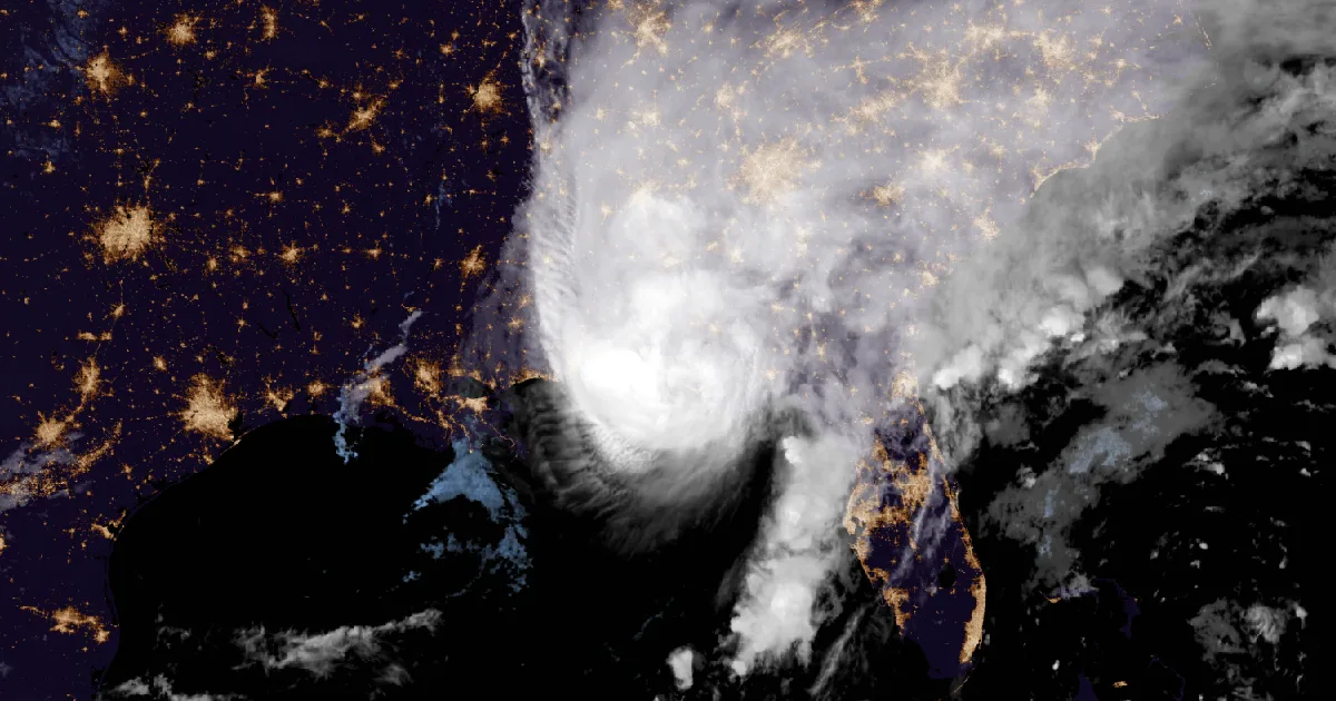
Isaias came ashore near Destin at 8:30 p.m. CDT Friday at 105 mph. By morning 5 to 12 inches had fallen in southeast Alabama and Atlanta was under a flash.

Key points
- Isaias made landfall near Destin, Florida, at about 8:30 p.m. CDT Friday with 105 mph sustained winds. A gust of 116 mph was reported near Santa Rosa Sound. By 4 a.m. CDT Saturday it had weakened to a 35 mph post-tropical low south of Montgomery.
- The rain kept going after the wind dropped. NWS Tallahassee put Friday night's rain at 5 to 12 inches across Coffee, Dale and Geneva counties in Alabama. The Shoal River near Mossy Head, Florida, is forecast to crest a tenth of a foot above its April 1978 crest.
- On Saturday morning Flash Flood Warnings covered metro Atlanta and downtown Charleston, and High Wind Warnings ran from north Alabama into the Smokies. The National Hurricane Center said heavy rain would spread into the Tennessee Valley and the Southern Appalachians today.
Yesterday: landfall on the Emerald Coast
Isaias came ashore Friday evening. At 8:30 p.m. CDT the National Hurricane Center said Doppler radar showed the hurricane making landfall "near Destin, Florida, around 830 PM CDT (0130 UTC) with maximum sustained winds of 105 mph", with an estimated minimum central pressure of 971 mb. The same update gave the night's two largest gusts. A WeatherFlow station near Santa Rosa Sound recorded 116 mph with a 91 mph sustained wind, and a WeatherSTEM station near Pensacola recorded 100 mph. Half an hour earlier, the Pensacola City Hall station had reported a 102 mph gust.
Water rose on the east side of the eye. The NOAA National Ocean Service gauge at Panama City Beach read 5.6 feet above mean higher high water at the 8:30 p.m. update. The Hurricane Center says that number approximates the depth of inundation in that area.
After that the storm weakened quickly over land. At 10 p.m. CDT it was a 90 mph hurricane 45 miles east-northeast of Pensacola. At 1 a.m. it was a 65 mph post-tropical cyclone 55 miles south-southwest of Montgomery. Advisory 15 came out at 4 a.m. CDT. It put the center 25 miles south-southwest of Montgomery with 35 mph winds, cancelled every remaining storm surge and tropical storm warning, and was the Hurricane Center's last advisory on Isaias. Forecaster Blake wrote that Isaias "has very rapidly weakened over Alabama". He added that all of its deep convection had been "scoured well northward away from the low-level center."
| Time (CDT) | Product | Position | Max sustained | Pressure |
|---|---|---|---|---|
| Fri 6:00 p.m. | Update | 55 mi SSE of Pensacola | 115 mph | 960 mb |
| Fri 8:30 p.m. | Landfall update | near Destin FL, 30.4N 86.5W | 105 mph | 971 mb |
| Fri 10:00 p.m. | Advisory 14 | 45 mi ENE of Pensacola | 90 mph | 982 mb |
| Sat 1:00 a.m. | Advisory 14A | 55 mi SSW of Montgomery | 65 mph | 1000 mb |
| Sat 4:00 a.m. | Advisory 15 (final NHC) | 25 mi SSW of Montgomery | 35 mph | 1002 mb |
| Measured Friday evening (NHC updates) | Gust | Sustained |
|---|---|---|
| WeatherFlow, near Santa Rosa Sound FL | 116 mph | 91 mph |
| Pensacola City Hall | 102 mph | 62 mph |
| WeatherSTEM, near Pensacola FL | 100 mph | 63 mph |
| NOS station, Panama City Beach FL | 83 mph | 72 mph |
| Panama City Beach water level | 5.6 ft above MHHW |
*Sources: National Hurricane Center Tropical Cyclone Updates (6:00, 8:00, 8:30 and 9:00 p.m. CDT Friday) and Advisories 14, 14A and 15. Station reports are as NHC relayed them and are preliminary.*
Overnight: the rain that stayed
When the wind dropped, the water was still arriving. At 2:32 a.m. CDT NWS Tallahassee wrote that "Extremely heavy rain on Friday night due to Hurricane Isaias brought 5 to 12 inches of rain" to Coffee, western Dale and Geneva counties in southeast Alabama. The product added that numerous roads remained closed and that streams would keep rising for several more hours as the water moved downstream. It lists Enterprise, Elba, Ozark, Daleville, Geneva and Fort Rucker among the places affected.
The rivers are now taking that water. At 4:57 a.m. CDT NWS Tallahassee raised the Shoal River near Mossy Head, in Walton County, Florida, from moderate to major flooding. The stage was 16.9 feet at 4:15 a.m., against a flood stage of 14.0. The forecast crest is 20.8 feet this afternoon. The product's own flood history line compares that crest with 20.7 feet on 13 April 1978. Downstream, NWS Mobile expects the Shoal River near Crestview to crest at 14.9 feet Sunday evening, against a previous crest of 14.8 feet in July 1994.
Today, officially
The Hurricane Center's final advisory said Isaias would move across Alabama and into the Tennessee Valley today and dissipate on Sunday. Through the weekend it expects 4 to 8 inches of rain across southern Alabama, the Florida Panhandle and Big Bend, and southwest Georgia, with local totals up to 15 inches. Much of the rest of the Southeast should get 2 to 5 inches, with up to 10 inches possible in the Southern Appalachians and on the Carolina coast. The advisory also says "Considerable flash flooding and landslides are also possible across the Southern Appalachians." From 10 a.m. CDT the advisories pass to the Weather Prediction Center.
The rain had reached Atlanta by breakfast. At 7:12 a.m. EDT NWS Peachtree City issued a Flash Flood Warning until 1:15 p.m. for parts of Clayton, DeKalb, Fulton, Gwinnett, Henry and Rockdale counties. The warning said radar showed 1 to 3 inches already fallen and 2 to 3 more possible. At 7:23 a.m. NWS Charleston issued a Flash Flood Warning for downtown Charleston, South Carolina, based on a report from city emergency management. The report described several road closures and an inundation sensor on Ogier Street reading more than half a foot.
As of the morning Storm Prediction Center Day 1 outlook, the highest risk is Slight. The outlook says thunderstorms that could bring tornadoes are possible from the eastern Florida Panhandle northeast into the Carolinas.
The wind has gone inland as well. High Wind Warnings run from Birmingham's and Huntsville's counties in north Alabama across north Georgia to the North Carolina and Tennessee mountains. The strongest gusts in the products are 70 mph, in Morristown's east Tennessee mountain zones.
| Office | Product | Area | Numbers | Until |
|---|---|---|---|---|
| Peachtree City GA | Flash Flood Warning | Atlanta, Decatur, Sandy Springs, McDonough, Jonesboro | 1 to 3 in fallen, 2 to 3 in more possible | 1:15 p.m. EDT Sat |
| Peachtree City GA | Flash Flood Warning | Griffin, McDonough, Zebulon (Henry, Lamar, Pike, Spalding) | 1.5 to 2.5 in fallen | 11:45 a.m. EDT Sat |
| Charleston SC | Flash Flood Warning | Downtown Charleston, James Island, Folly Beach | 1 to 2 in fallen | 9:30 a.m. EDT Sat |
| Tallahassee FL | Flood Warning | Coffee, Dale, Geneva AL | 5 to 12 in fell Friday night | 11:45 a.m. CDT Sat |
| Tallahassee FL | Flood Warning | Shoal River near Mossy Head FL | crest 20.8 ft, flood stage 14.0 | Sunday evening |
| Mobile AL | Flood Warning | Shoal River near Crestview FL | crest 14.9 ft, flood stage 8.0 | Tuesday afternoon |
| Huntsville AL | High Wind Warning | Madison, Morgan, Marshall, Jackson, DeKalb, Cullman | gusts 50 to 60 mph | 7 p.m. CDT Sat |
| Birmingham AL | High Wind Warning | Blount, Etowah, Calhoun, Cherokee, Cleburne | gusts to 45 mph | 7 p.m. CDT Sat |
| Peachtree City GA | High Wind Warning | north Georgia | gusts to 50 mph | 8 a.m. EDT Sun |
| Greenville-Spartanburg SC | High Wind Warning | western North Carolina above 3,500 ft | gusts to 60 mph | 8 a.m. EDT Sun |
| Morristown TN | High Wind Warning | east Tennessee, southwest North Carolina, southwest Virginia mountains | gusts to 70 mph | 8 a.m. EDT Sun |
*Sources: NWS warnings as issued Saturday morning. Rain totals are the products' own radar estimates. Times are local.*
The Hurricane Center's last discussion closed with its post-storm advice: avoid downed power lines and floodwater, and keep generators outside, at least 20 feet from homes and garages, because of carbon monoxide.
This is a summary of official warnings, not emergency information. For live warnings see weather.gov and your local officials. The National Hurricane Center: https://www.nhc.noaa.gov/
The rock's live forecast for the places in this story
More from the Journal
 THE WEATHER BEAT
Isaias reaches 85 mph as Tropical Storm, High Wind and Flood Watches spread inland to Alabama, Georgia and Tennessee
OCT 8
THE WEATHER BEAT
Isaias reaches 85 mph as Tropical Storm, High Wind and Flood Watches spread inland to Alabama, Georgia and Tennessee
OCT 8
 THE WEATHER BEAT
Downtown Los Angeles hits a record 104, its fourth straight 100-degree day, as heat watches reach the Coachella Valley
OCT 6
THE WEATHER BEAT
Downtown Los Angeles hits a record 104, its fourth straight 100-degree day, as heat watches reach the Coachella Valley
OCT 6
 EXPLAINERS
Why Is the Sky Blue?
AUG 20
EXPLAINERS
Why Is the Sky Blue?
AUG 20
Follow the Journal: RSS · get it by email