THE WEATHER BEAT · OCT 9
Rachel brings a Tropical Storm Watch to the San Diego County coast, with surf, rain and wind expected Sunday
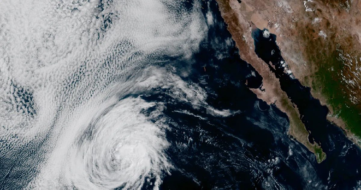
The National Hurricane Center put a Tropical Storm Watch on the Southern California coast Friday morning after Rachel's track shifted north. NWS San Diego.

Key points
- The National Hurricane Center issued a Tropical Storm Watch for the Southern California coast at 8 a.m. PDT Friday. It runs from the U.S./Mexico border north to the San Diego/Orange County line, ahead of Tropical Storm Rachel. NWS San Diego extended it to the county's coast, valleys, mountains and deserts.
- At 11 a.m. PDT Rachel had 50 mph winds and was about 800 miles southwest of San Diego, moving northeast at 5 mph. The Center expects it to approach northern Baja California or Southern California late Saturday or early Sunday and then weaken quickly over the Southwest.
- NWS San Diego's main concerns are coastal flooding, wind and periods of heavy rain on Sunday. It says "Confidence in impactful coastal flooding is high." In the most likely case, the coast, valleys and deserts get 0.25 to 1 inch of rain and the mountains get 1 to 2 inches.
Rachel turns toward California
Rachel has been in the eastern Pacific for more than a week. On Monday the Los Angeles forecasters already mentioned its moisture as a possible source of showers once the heat broke. This morning it turned into a story of its own. In its 8 a.m. PDT advisory the Hurricane Center put up Tropical Storm Watches for Southern California and for both coasts of northern Baja California. Its headline: "TROPICAL STORM WATCHES ISSUED FOR SOUTHERN CALIFORNIA AND BAJA CALIFORNIA."
The reason was a shift in the track. The Center's discussion said "There has been a northward shift in the latest track guidance," with the global and hurricane models "now bringing the center near the U.S./Mexico border or into extreme southern California." The storm itself is not strong. The discussion described it as "struggling to maintain deep convection." The Center held the winds at 50 mph and expects only modest strengthening before a trough carries the storm northeast and speeds it up.
The Center's forecast shows the storm at its strongest, about 65 mph, off northern Baja on Saturday afternoon. By early Sunday the center is forecast to be inland, and by Sunday evening Rachel is forecast to be post-tropical over the interior Southwest. The Center also expects a sharp contrast across the storm, with the strongest winds mostly in its eastern and southern half.
| Item | Advisory 50 (8 a.m. PDT Fri) | Intermediate Advisory 50A (11 a.m. PDT Fri) |
|---|---|---|
| Center | 22.8N 124.6W | 23.1N 124.5W |
| Distance | About 935 mi W of the southern tip of Baja California | About 800 mi SW of San Diego |
| Max sustained winds | 50 mph | 50 mph |
| Pressure | 994 mb (29.36 in) | |
| Movement | NE, 5 mph | NE, 5 mph |
| Tropical-storm-force winds reach | 80 mi from center | |
| Coastal change | Tropical Storm Watch issued, U.S./Mexico border to San Diego/Orange County line | none |
| NHC forecast point (Discussion 50) | Position | Max winds |
|---|---|---|
| Fri 5 p.m. PDT | 23.4N 123.6W | 50 mph |
| Sat 5 a.m. PDT | 25.1N 121.0W | 60 mph |
| Sat 5 p.m. PDT | 28.5N 118.1W | 65 mph |
| Sun 5 a.m. PDT | 33.3N 116.0W, inland | 50 mph |
| Sun 5 p.m. PDT | 38.1N 114.0W, post-tropical, inland | 40 mph |
| Mon 5 a.m. PDT | dissipated |
*Sources: National Hurricane Center Tropical Storm Rachel Advisory 50 and Discussion 50 (8 a.m. PDT Fri) and Intermediate Advisory 50A (11 a.m. PDT Fri). Forecast times are converted from UTC. These are forecasts, not measurements.*
San Diego County: surf, rain and wind on Sunday
NWS San Diego's statement, issued at 8:22 a.m. PDT, lists coastal flooding, wind and periods of heavy rain. The coast comes first. Rachel's south swell is due Sunday. Mornings already bring high tides near 7 feet, and with the swell and wind waves on top, the office expects coastal flooding and beach erosion on San Diego County beaches. It puts Sunday's surf at 5 to 7 feet with sets to 9 feet, easing to 3 to 6 feet Monday and Tuesday.
The rain forecast depends on the track, and the office explains why. The heaviest rain falls on the southeast side of the storm, so a track farther north would spread heavy rain across the whole county, and a track farther south would keep it more local. The office is most confident about the mountains and deserts. It says the case that about half of the guidance shows would give the coast, valleys and deserts "a soaking rain between 0.25-1" Sunday, with 1 to 2 inches in the mountains. Its higher-end case gives 1 to 2 inches across the lower ground and 2 to 4 in the mountains. The statement says the flooding risk is highest "in and below recently burned areas."
The wind looks smaller than the water. Each zone's watch says winds of 39 to 57 mph are possible. In the current local forecast, though, peak gusts are about 30 mph on the coast and in the valleys and about 45 mph in the mountains and deserts. The office expects the strongest winds in the southern part of the county. It says places north of San Diego County should also expect coastal flooding, possible heavy rain and higher winds.
| NWS San Diego zone (watch issued 7:59 a.m. PDT Fri) | Towns named | Peak wind in the current forecast |
|---|---|---|
| Coastal Areas | Oceanside, Carlsbad, San Diego, Chula Vista | 10 to 20 mph, gusts to 30 |
| Inland Valleys | Escondido, El Cajon, Lakeside, Poway | 10 to 15 mph, gusts to 30 |
| Mountains | Julian, Pine Valley | 20 to 30 mph, gusts to 45 |
| Deserts | Borrego Springs | 20 to 30 mph, gusts to 45 |
| Coastal waters, San Mateo Point to the border, out to 60 nm (8:03 a.m. PDT) | San Clemente Island | tropical storm force possible Sunday, seas 6 to 10 ft |
| Sunday rain, NWS San Diego scenarios | Coast, valleys, deserts | Mountains |
|---|---|---|
| Most likely (about 50% of solutions) | 0.25 to 1 in | 1 to 2 in |
| Higher end | 1 to 2 in | 2 to 4 in |
*Sources: NWS San Diego Tropical Cyclone Local Statement (8:22 a.m. PDT Fri); NWS San Diego Tropical Storm Watches for the county zones (7:59 a.m. PDT) and coastal waters (8:03 a.m. PDT). Forecast amounts, not measurements.*
The Center says that beyond San Diego, Rachel and its moisture will bring 1 to 3 inches of rain to parts of the Southwest this weekend, locally up to 5 inches, "with potential for flash and urban flooding." It also expects damaging gusts over interior high ground Saturday night and Sunday. Its fourth key message says the swells are "likely to cause life-threatening surf and rip current conditions, as well as moderate to isolated major coastal flooding, through early next week."
On the Gulf Coast, the Center's 1 p.m. CDT advisory had Hurricane Isaias at 120 mph, a Category 3. The Center expects landfall inside the Hurricane Warning this evening. This morning's story is at /journal/beat/isaias-110-mph-landfall-tonight-panhandle-alabama-2026-10-09/.
The federal guide for getting ready is at https://www.ready.gov/hurricanes.
This is a summary of official warnings, not emergency information. For live warnings see weather.gov and your local officials. NWS San Diego: https://www.weather.gov/sgx/ The National Hurricane Center: https://www.nhc.noaa.gov/
The rock's live forecast for the places in this story
More from the Journal
 THE WEATHER BEAT
Flood Watch for Kauai, Niihau and Oahu from Wednesday evening into Thursday as southerly winds draw up tropical moisture
OCT 7
THE WEATHER BEAT
Flood Watch for Kauai, Niihau and Oahu from Wednesday evening into Thursday as southerly winds draw up tropical moisture
OCT 7
 THE WEATHER BEAT
Isaias brings the first Hurricane Watch to the northern Gulf Coast, Bay St. Louis to Indian Pass, with hurricane conditions possible late Friday
OCT 7
THE WEATHER BEAT
Isaias brings the first Hurricane Watch to the northern Gulf Coast, Bay St. Louis to Indian Pass, with hurricane conditions possible late Friday
OCT 7
 EXPLAINERS
Why Is the Sky Blue?
AUG 20
EXPLAINERS
Why Is the Sky Blue?
AUG 20
Follow the Journal: RSS · get it by email