THE WEATHER BEAT · OCT 10
Rachel's moisture brings Flood Watches to four states and Coastal Flood Warnings from Malibu to San Diego
Rachel's moisture put Flood Watches up from six NWS offices in four states, and Coastal Flood Warnings cover the beaches from Malibu to San Diego.

Key points
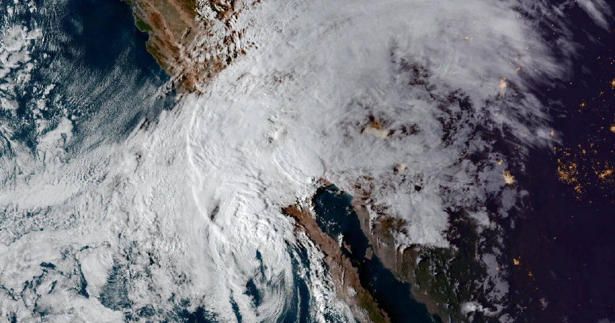
- As of the National Hurricane Center's 5 p.m. PDT advisory, Tropical Storm Rachel had 65 mph winds and was 365 miles south of San Diego, moving north-northeast at 30 mph. The Center expects it to move onshore in northern Baja California tonight and its remnants to cross the Southwest on Sunday.
- Six National Weather Service offices have Flood Watches out across parts of California, Arizona, Nevada and Utah: San Diego, Phoenix, Las Vegas, Flagstaff, Elko and Salt Lake City. All of them cite Rachel's moisture or its remnants.
- Coastal Flood Warnings cover the San Diego and Orange County coasts until 3 p.m. PDT Sunday, and the Malibu Coast and Los Angeles County beaches through Sunday. Los Angeles expects tides near 8 feet on Sunday morning.
Rachel speeds up and heads for Baja
On Friday morning Rachel was a 50 mph storm 800 miles out, drifting at 5 mph, and the Tropical Storm Watch for San Diego County was the whole story. By Saturday evening the storm had picked up speed and closed most of that distance. The Hurricane Center's 5 p.m. PDT advisory put it 365 miles south of San Diego, moving north-northeast at 30 mph with 65 mph winds. That matches the peak the Center forecast on Friday for Saturday afternoon. Tropical-storm-force winds now reach 140 miles from the center, up from 80 miles on Friday.
None of Saturday's three advisories (11 a.m., 2 p.m. and 5 p.m. PDT) changed a coastal watch or warning. The watch from the border to the San Diego/Orange County line still stands. The Center expects the center to move onshore in northern Baja California tonight, and expects "Rachel's post-tropical remnants" to cross the southwestern United States on Sunday and dissipate there. Its rainfall line has not changed: 1 to 3 inches over parts of the Southwest this weekend, locally up to 5, "and potential for significant flash and urban flooding."
| Item | Advisory 50A (11 a.m. PDT Fri) | Advisory 55A (5 p.m. PDT Sat) |
|---|---|---|
| Center | 23.1N 124.5W | 27.4N 116.7W |
| Distance | About 800 mi SW of San Diego | About 365 mi S of San Diego |
| Max sustained winds | 50 mph | 65 mph |
| Pressure | 994 mb | 989 mb (29.21 in) |
| Movement | NE, 5 mph | NNE, 30 mph |
| Tropical-storm-force winds reach | 80 mi | 140 mi |
| Coastal change | none | none |
*Sources: National Hurricane Center Tropical Storm Rachel Intermediate Advisory 50A (11 a.m. PDT Fri), Advisory 55 (2 p.m. PDT Sat) and Intermediate Advisory 55A (5 p.m. PDT Sat). These are advisory positions and forecasts, not measurements on land.*
The water on the coast
On Friday NWS San Diego wrote that "Confidence in impactful coastal flooding is high." By Saturday afternoon that had become a warning. The San Diego office's Coastal Flood Warning, issued at 1:38 p.m. PDT, covers the San Diego County and Orange County coasts until 3 p.m. Sunday. It says significant coastal flooding and erosion are likely and that "numerous roads and walking paths may be closed due to high water." A Coastal Flood Advisory follows from Sunday afternoon to Tuesday afternoon.
Los Angeles issued its own warning at 1:51 p.m. PDT for the Malibu Coast and the Los Angeles County beaches. It expects tides around 8 feet near Sunday morning's high tide. Low pressure and onshore winds push those tides higher, with 5 to 8 foot surf on top, and the office names the south-facing beaches as the most exposed.
The two San Diego products give slightly different surf numbers, and both are listed below as written. The warning gives 5 to 7 feet with local sets to 9. The 2 p.m. statement gives a Sunday peak of 6 to 9 feet, easing to 3 to 6 feet Monday and Tuesday.
| Product | Area | Through | Key figure |
|---|---|---|---|
| Coastal Flood Warning, NWS San Diego (1:38 p.m. PDT) | San Diego and Orange County coasts | 3 p.m. PDT Sun | surf 5 to 7 ft, local sets to 9 ft |
| Coastal Flood Warning, NWS Los Angeles (1:51 p.m. PDT) | Malibu Coast, Los Angeles County beaches | Sunday | tide near 8 ft Sun morning, surf 5 to 8 ft |
| Tropical Cyclone Local Statement, NWS San Diego (2 p.m. PDT) | San Diego County | Sunday | surf peak 6 to 9 ft, high tides over 7 ft |
*Sources: the NWS products named in the table. Forecast values, not measurements.*
The rain, from San Diego to the Wasatch
San Diego's statement raised its Sunday rain numbers since Friday. Friday's most likely case was 0.25 to 1 inch for the coast, valleys and deserts and 1 to 2 inches for the mountains. The 2 p.m. PDT statement gives 0.50 to 1.25 inches and 1 to 2.5 inches. It allows rates up to 1 inch an hour in the mountains and says "areas of flash and urban flooding are probable." A Flood Advisory issued at 3:26 p.m. PDT forecasts the San Diego River at Fashion Valley to peak at 8.1 feet, its action stage, just before noon Sunday. The 2 p.m. statement had 8.0 feet. At 7.5 feet the advisory says low-lying roads around Fashion Valley Mall begin to flood.
Inland, the watches follow the moisture north. Phoenix's watch covers Joshua Tree National Park and Chiriaco Summit, with rates up to an inch an hour possible. The Las Vegas office's watch covers the Las Vegas Valley, Lake Mead, Lake Havasu, the Mojave Desert and Death Valley. Flagstaff's covers the Grand Canyon country, the Mogollon Rim and Oak Creek Canyon. It warns of "raging killer currents" in side canyons and slot canyons. Elko lists the burn scars of eight former fires. Salt Lake City's two watches run through Monday afternoon and cover most of Utah, from Zion National Park and Lake Powell to the Salt Lake Valley and Cache Valley.
Rachel's moisture reaches beyond the flood watches. This afternoon's Montana story reported that the Great Falls office expects Rachel's remnants to spread snow into southwest Montana on Sunday.
| Office | Flood Watch area (abridged) | Through |
|---|---|---|
| San Diego (11:36 a.m. PDT) | All of San Diego County, Riverside and San Bernardino County mountains, Coachella Valley, San Gorgonio Pass near Banning | from 11 p.m. PDT Sat through Sunday evening |
| Phoenix (12:03 p.m. PDT) | Joshua Tree NP, Chiriaco Summit | from 5 p.m. PDT Sat through Sunday afternoon |
| Las Vegas (10:58 a.m. PDT) | Las Vegas Valley, Lake Mead, Lake Havasu, Mojave Desert, Death Valley NP, Lincoln County | late Sunday night |
| Flagstaff (11:08 a.m. MST) | Western Coconino, northern Gila, far southern Navajo and Yavapai counties | late Sunday night |
| Elko (10:48 a.m. PDT) | Elko, White Pine, southern Lander and Eureka, northern Nye counties | late Sunday night |
| Salt Lake City (3:44 p.m. MDT) | Southwest and central Utah, Zion NP, Lake Powell, Wasatch Front, Salt Lake and Utah valleys | Monday afternoon |
| Sunday rain, NWS San Diego | Coast, valleys, deserts | Mountains |
|---|---|---|
| Friday 8:22 a.m. PDT, most likely case | 0.25 to 1 in | 1 to 2 in |
| Saturday 2 p.m. PDT, current forecast | 0.50 to 1.25 in | 1 to 2.5 in |
*Sources: the NWS Flood Watches named in the table, the NWS San Diego Tropical Cyclone Local Statements of 8:22 a.m. PDT Fri and 2 p.m. PDT Sat, and the NWS San Diego Flood Advisory (3:26 p.m. PDT Sat). Forecast amounts, not measurements. Elko's watch text calls the storm "decaying Hurricane Rachel"; the National Hurricane Center lists Rachel as a tropical storm, and this story uses the Center's classification.*
Friday's story on the first watch is at /journal/beat/rachel-tropical-storm-watch-san-diego-county-2026-10-09/. The federal guide for getting ready is at https://www.ready.gov/hurricanes.
This is a summary of official warnings, not emergency information. For live warnings see weather.gov and your local officials. NWS San Diego: https://www.weather.gov/sgx/ The National Hurricane Center: https://www.nhc.noaa.gov/
The rock's live forecast for the places in this story
More from the Journal
 THE WEATHER BEAT
Isaias reaches the Pensacola coast at 110 mph as Extreme Wind Warnings go up and Butler County, Alabama, moves to a Hurricane Warning
OCT 9
THE WEATHER BEAT
Isaias reaches the Pensacola coast at 110 mph as Extreme Wind Warnings go up and Butler County, Alabama, moves to a Hurricane Warning
OCT 9
 THE WEATHER BEAT
Flood Watch for Kauai, Niihau and Oahu from Wednesday evening into Thursday as southerly winds draw up tropical moisture
OCT 7
THE WEATHER BEAT
Flood Watch for Kauai, Niihau and Oahu from Wednesday evening into Thursday as southerly winds draw up tropical moisture
OCT 7
 EXPLAINERS
Why Is the Sky Blue?
AUG 20
EXPLAINERS
Why Is the Sky Blue?
AUG 20
Follow the Journal: RSS · get it by email