THE WEATHER BEAT · OCT 9
Isaias reaches the Pensacola coast at 110 mph as Extreme Wind Warnings go up and Butler County, Alabama, moves to a Hurricane Warning
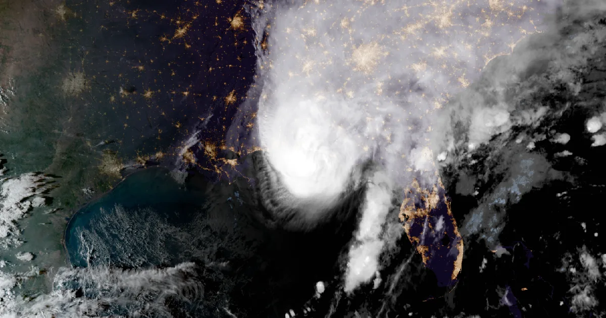
At 7 p.m. CDT Isaias was 45 miles from Pensacola at 110 mph, with gusts to 97 mph at Gulf Breeze and 15 Flash Flood Warnings across the Panhandle.

Key points
- At 7 p.m. CDT the National Hurricane Center put Isaias 45 miles southeast of Pensacola. It had 110 mph winds and a pressure of 967 mb, and was moving north at 18 mph. The Center expected landfall on the western Florida Panhandle "within the next hour or two."
- At 5:45 p.m. CDT the NWS offices in Mobile and Tallahassee issued Extreme Wind Warnings for the eyewall coast from southeastern Escambia County through southwestern Walton County. Weather stations near Gulf Breeze measured a sustained wind of 83 mph and a gust of 97 mph.
- The warnings also grew inland on Friday. Butler, Crenshaw and Monroe counties in Alabama moved up to a Hurricane Warning. High Wind Watches from north Alabama to the Smokies became High Wind Warnings. Fifteen Flash Flood Warnings covered the Panhandle and the Big Bend.
Isaias Friday evening: at the coast, and gustier than its number
Isaias crossed the last of the Gulf on Friday afternoon and lost a little strength on the way. Its winds peaked near 120 mph in the 1 p.m. CDT advisory. By 7 p.m. they were 110 mph and the pressure had risen to 967 mb. The Center's 4 p.m. discussion explained the drop. Wind shear from the southwest had risen to 30 to 40 knots, and the storm had grown lopsided, with "very intense convection mainly confined to the northern eyewall." Dropsondes found winds falling off sharply near the water's surface. The discussion also warned that the lower number may undersell what people feel: "it's very likely that Isaias will be a gustier-than-normal hurricane when it makes landfall," and its fast motion "could bring strong hurricane-force gusts well inland."
The measurements climbed through the evening. At 1 p.m. the strongest gust the Center reported was 47 mph at Dauphin Island. By 6 p.m. a NOAA buoy in the Gulf had measured a gust of 81 mph and a station near Perdido Bay one of 75 mph. The 7 p.m. advisory carried a sustained wind of 83 mph and a gust of 97 mph from a WeatherFlow station in Gulf Breeze, and a 71 mph gust at Pensacola International Airport.
At 5:44 p.m. CDT, radar and the Hurricane Hunters found the eyewall's strongest winds 11 to 18 miles off the coast, moving north at 15 mph. The Mobile office issued an Extreme Wind Warning a minute later for southern Okaloosa, southern Santa Rosa and southeastern Escambia counties, until 8:45 p.m. CDT. The towns it named included Pensacola, Gulf Breeze, Milton, Niceville, Fort Walton Beach and Destin. Tallahassee issued the same warning for southwestern Walton County.
The surge forecast also changed during the day without a single watch or warning line moving. This morning's Advisory 11 had 5 to 7 feet from Dauphin Island to Indian Pass. By the afternoon, the highest band was 6 to 9 feet from the Alabama and Florida border to Grayton Beach.
| Item | 4 a.m. CDT (Adv 11, this morning's story) | 1 p.m. CDT (Adv 12A) | 4 p.m. CDT (Adv 13) | 6 p.m. CDT (Update) | 7 p.m. CDT (Adv 13A) |
|---|---|---|---|---|---|
| Center | 26.4N 88.0W | 28.4N 87.2W | 29.2N 87.0W | 29.8N 86.8W | 30.1N 86.6W |
| Distance | 200 mi SSE of the mouth of the Mississippi | 145 mi S of Pensacola | 90 mi S of Pensacola | 55 mi SSE of Pensacola | 45 mi SE of Pensacola |
| Max sustained winds | 110 mph | 120 mph | 115 mph | 115 mph | 110 mph |
| Pressure | 963 mb | 959 mb | 959 mb | 960 mb | 967 mb (28.56 in) |
| Movement | NNE, 15 mph | NNE, 16 mph | N, 17 mph | N, 18 mph | N, 18 mph |
| Coastal change | none | none | none | none |
| Reported wind (as the Center quoted it) | Sustained | Gust | Advisory |
|---|---|---|---|
| Dauphin Island, AL | 47 mph | 12A, 1 p.m. CDT | |
| Fair Point Light 2, near Gulf Breeze, FL | 46 mph | 58 mph | 13, 4 p.m. CDT |
| Pensacola Naval Air Station, FL | 56 mph | 13, 4 p.m. CDT | |
| NDBC Buoy 42028, Gulf | 81 mph | Update, 6 p.m. CDT | |
| WeatherFlow, near Perdido Bay | 75 mph | Update, 6 p.m. CDT | |
| WeatherFlow, Gulf Breeze, FL | 83 mph | 97 mph | 13A, 7 p.m. CDT |
| Pensacola International Airport (KPNS) | 71 mph | 13A, 7 p.m. CDT |
| Peak surge if it arrives at high tide | Adv 11 (4 a.m. CDT) | Adv 13A (7 p.m. CDT) |
|---|---|---|
| AL/FL Border to Grayton Beach, FL | 5 to 7 ft (inside Dauphin Island to Indian Pass) | 6 to 9 ft |
| Grayton Beach to Indian Pass, FL | 5 to 7 ft | 4 to 7 ft |
| Dauphin Island, AL to AL/FL Border | 5 to 7 ft | 4 to 6 ft |
| Indian Pass to Steinhatchee River, FL | 4 to 6 ft | 4 to 6 ft |
| Steinhatchee River to Suwannee River, FL | 3 to 5 ft | 3 to 5 ft |
| Mouth of the Mississippi to Dauphin Island; Lower Mobile Bay | 3 to 5 ft | 3 to 5 ft |
| Suwannee River to Yankeetown, FL; Upper Mobile Bay | 2 to 4 ft | 2 to 4 ft |
*Sources: National Hurricane Center Isaias Advisory 11, Intermediate Advisory 12A, Advisory 13 and Discussion 13, Tropical Cyclone Update (6 p.m. CDT), Intermediate Advisory 13A; NWS Mobile and Tallahassee Extreme Wind Warnings, 5:45 and 5:46 p.m. CDT. Wind reports are preliminary, as the Center quoted them. Surge figures are forecasts, not measurements.*
Inland: a Hurricane Warning reaches Butler County, and the wind watches became warnings
At 7:14 p.m. CDT the Mobile office upgraded Butler, Crenshaw and Monroe counties in south Alabama from a Tropical Storm Warning to a Hurricane Warning. That fits Advisory 13A, which expected hurricane-force winds to reach "as far as 100 miles from the coast into southern Alabama." Earlier in the day, Jackson, Mississippi, Memphis, Mobile and Peachtree City raised Tropical Storm Watches to warnings across east Mississippi and west-central Georgia, including Muscogee and Troup counties.
Farther north, the High Wind Watches in this morning's story became warnings by evening. Most of them run from late tonight into Sunday morning. The strongest gusts are again on the high ground: Morristown's warning for the Smoky Mountain zones says gusts up to 70 mph.
| Office, issue time | Upgrade or warning | Counties or zones | Gusts | When |
|---|---|---|---|---|
| NWS Mobile AL, 7:14 p.m. CDT | Tropical Storm Warning to Hurricane Warning | Butler, Crenshaw, Monroe AL | ||
| NWS Mobile AL, 1:09 p.m. CDT | Tropical Storm Watch to Warning | Perry, Stone, Wayne MS | ||
| NWS Jackson MS, 1:06 p.m. CDT | Tropical Storm Watch to Warning, plus new warning for Choctaw and Webster | Clarke, Clay, Forrest, Jasper, Jones, Kemper, Lauderdale, Lowndes, Neshoba, Newton, Noxubee, Oktibbeha, Winston | ||
| NWS Memphis TN, 1:42 p.m. CDT | New Tropical Storm Warning | Chickasaw, Itawamba, Lee, Monroe MS | ||
| NWS Peachtree City GA, 11:38 a.m. EDT | Tropical Storm Watch to Warning | 16 west-central Georgia counties, including Muscogee, Troup, Harris, Meriwether, Sumter | ||
| NWS Huntsville AL, 11:34 a.m. CDT | High Wind Warning | Cullman, Madison, Morgan, DeKalb, Jackson, Marshall | up to 60 mph | 1 a.m. Sat to 7 a.m. CDT Sun |
| NWS Peachtree City GA, 11:02 a.m. EDT | High Wind Warning | North and west-central Georgia, including Floyd, Bartow, Cherokee, Forsyth, Hall | up to 50 mph, stronger in the mountains | midnight tonight to 8 a.m. EDT Sun |
| NWS Birmingham AL, 5:17 p.m. CDT | High Wind Warning | Blount, Calhoun, Cherokee, Cleburne, Etowah | up to 55 mph | 1 a.m. Sat to 1 a.m. CDT Sun |
| NWS Morristown TN, 4:48 p.m. EDT | High Wind Warning | Blount, Cocke and Sevier Smoky Mountains, Johnson, Unicoi, Southeast Carter, Southeast Greene, Southeast Monroe, East Polk, and others | up to 70 mph | midnight tonight to 8 a.m. EDT Sun |
| NWS Morristown TN, 4:48 p.m. EDT | High Wind Warning | Cherokee and Clay NC | up to 60 mph | midnight tonight to 8 a.m. EDT Sun |
| NWS Greenville-Spartanburg SC, 5:19 p.m. EDT | High Wind Warning above 3,500 ft | Western North Carolina mountains, Graham and Macon to Mitchell | up to 60 mph | from midnight tonight |
*Sources: NWS Tropical Cyclone Local Statements (Mobile, Jackson MS, Memphis, Peachtree City) and High Wind Warnings from Huntsville, Peachtree City, Birmingham, Morristown and Greenville-Spartanburg, as issued Friday.*
The rain arrived ahead of the eye
The flooding began before the center reached the coast. At 4:35 p.m. CDT, Tallahassee reported that local law enforcement had found flooded roads across Lynn Haven and Panama City. By 7:37 p.m. CDT, the Mobile and Tallahassee offices had issued 15 Flash Flood Warnings covering 15 Panhandle and Big Bend counties, from Escambia east to Leon and Wakulla. In the 7:14 p.m. CDT warning for southern Okaloosa County, radar estimated that 4 to 7 inches had already fallen. The rain forecast in Advisory 13A was the same as this morning's: 4 to 8 inches across southern Alabama, the Panhandle and Big Bend, and southwest Georgia, locally up to 15. Most of the rest of the Southeast was forecast to get 2 to 5 inches, locally up to 10, "especially across the Southern Appalachians and coastal Carolinas." The Storm Prediction Center's Day 1 outlook had a Slight Risk and expected the tornado potential to "continue increasing" tonight across the Florida Panhandle, southeast Alabama and southwest Georgia.
| Office | Flash Flood Warnings, 3:34 to 7:37 p.m. CDT Fri | Counties |
|---|---|---|
| NWS Mobile AL | 7 | Escambia, Santa Rosa, Okaloosa FL |
| NWS Tallahassee FL | 8 | Walton, Holmes, Washington, Bay, Jackson, Calhoun, Gulf, Franklin, Liberty, Wakulla, Gadsden, Leon FL |
*Sources: NWS Mobile and Tallahassee Flash Flood Warnings as issued; National Hurricane Center Advisory 13A; Storm Prediction Center Day 1 Convective Outlook. Radar estimates are preliminary; rain amounts in the advisory are forecasts.*
The Center's key messages asked people in the surge warning area to follow evacuation orders from local officials. For people under the Hurricane Warning, they said to "have a safe room to ride out the storm and prepare for long-duration power outages." Farther inland, they said to "secure loose outdoor items, avoid driving high-profile vehicles, prepare for power outages, and be aware of the potential for falling trees." The federal preparedness guide is at https://www.ready.gov/hurricanes. This morning's story is at /journal/beat/isaias-110-mph-landfall-tonight-panhandle-alabama-2026-10-09/.
This is a summary of official warnings, not emergency information. For live warnings see weather.gov and your local officials. The National Hurricane Center: https://www.nhc.noaa.gov/
The rock's live forecast for the places in this story
More from the Journal
 THE WEATHER BEAT
Isaias reaches 100 mph with the season's first eye as Montgomery and inland Walton County move under warnings
OCT 8
THE WEATHER BEAT
Isaias reaches 100 mph with the season's first eye as Montgomery and inland Walton County move under warnings
OCT 8
 THE WEATHER BEAT
Flood Watch for Kauai, Niihau and Oahu from Wednesday evening into Thursday as southerly winds draw up tropical moisture
OCT 7
THE WEATHER BEAT
Flood Watch for Kauai, Niihau and Oahu from Wednesday evening into Thursday as southerly winds draw up tropical moisture
OCT 7
 EXPLAINERS
Why Is the Sky Blue?
AUG 20
EXPLAINERS
Why Is the Sky Blue?
AUG 20
Follow the Journal: RSS · get it by email