THE WEATHER BEAT · OCT 7
Isaias reaches 65 mph Wednesday evening as Hurricane Watches reach inland Alabama and Tropical Storm Watches spread across 18 more counties
Coastal watches held steady Wednesday afternoon, but Isaias went from 45 to 65 mph by 7 p.m. CDT. Mobile and Tallahassee pushed the watches inland, and.

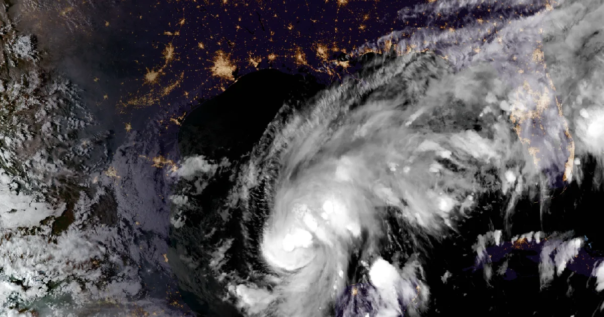
Key points
- At 7 p.m. CDT Wednesday the National Hurricane Center put Tropical Storm Isaias's top winds near 65 mph. That is up from 45 mph at 10 a.m. The Center expects it to become a hurricane by Thursday morning and to make landfall on the northern Gulf Coast late Friday or early Saturday.
- The coastal watches did not change this afternoon. Inland they grew: NWS Mobile added a Hurricane Watch for Conecuh, Covington and Escambia counties in Alabama. NWS Mobile and NWS Tallahassee together added Tropical Storm Watches for 18 counties in Alabama, Mississippi and the Florida Panhandle.
- The 4 p.m. CDT forecast has Isaias at its peak of about 110 mph Friday afternoon, before landfall. Rain from Friday through the weekend is now forecast at 3 to 7 inches, with local totals up to 10 inches, from far southeast Louisiana to the Florida Panhandle.
Isaias, Wednesday evening: stronger, and the watches move inland
Isaias spent Wednesday in the Bay of Campeche and grew faster than its track moved. At 10 a.m. CDT it had 45 mph winds and a central pressure of 1000 millibars. By the 4 p.m. advisory, a NOAA Hurricane Hunter crew had measured the pressure at 994 millibars, and the Hurricane Center raised the winds to 65 mph. Its 4 p.m. headline read: "Isaias quickly intensifying, forecast to be a hurricane by Thursday morning." At 7 p.m. the Center reported that Air Force Hurricane Hunters were in the storm again.
The track barely changed. The 4 p.m. discussion said Isaias "is basically on track," and the forecast was "adjusted slightly to the east." The first key message also changed its wording. Isaias "is expected to strengthen and be a strong hurricane when it approaches the northern Gulf Coast on Friday." On wind, the Center told people in the Hurricane Watch to "prepare for the possibility of long-duration power outages."
On the coast, the watch lines stayed where they were set this morning. Inland, they grew. Mobile's statement at 4:10 p.m. CDT added a Hurricane Watch for Conecuh, Covington and Escambia counties in Alabama. It also added a Tropical Storm Watch for eight counties in Alabama and Mississippi, as far north as Wilcox and Greene. Tallahassee's statement at 5:06 p.m. EDT added ten more counties to the Tropical Storm Watch, across southeast Alabama and the inland Florida Panhandle. Tallahassee explained why: "An expected fast forward speed may also lead to the wind threat extending further inland." Mobile said its rain forecast was held to 3 to 7 inches, with up to 10 near the coast, "with the fast speed of the hurricane at landfall." New Orleans dropped its Storm Surge Watch for Upper St. Bernard and still names Friday into Saturday as the most likely time for impacts.
In the evening statements, the storm sat about 630 miles south-southwest of Mobile, about 680 miles southwest of Panama City and about 530 miles south-southwest of New Orleans. There is still time, and every office says the same thing: the track and timing are still uncertain.
| Item | 10 a.m. CDT (Adv 4) | 7 p.m. CDT (Adv 5A) |
|---|---|---|
| Center | 22.4N 93.6W | 22.8N 92.4W |
| Distance | About 540 mi SSW of the mouth of the Mississippi | About 480 mi SSW of the mouth of the Mississippi; about 200 mi WNW of Progreso, Mexico |
| Max sustained winds | 45 mph | 65 mph |
| Tropical-storm-force wind radius | Up to 45 mi | Up to 60 mi |
| Pressure | 1000 mb | 994 mb (29.36 in) |
| Movement | ENE, 8 mph | ENE, 65 degrees, 8 mph |
| Rain, Fri through weekend, far SE Louisiana to the Florida Panhandle | 3 to 6 in, locally 10 | 3 to 7 in, locally 10 |
| Landfall wording | Approach the coast Friday | Landfall late Friday or early Saturday |
| Wind timing | TS conditions midday Friday, hurricane conditions late Friday | Unchanged |
| NHC forecast point (Discussion 5, 4 p.m. CDT) | Position | Max winds |
|---|---|---|
| Thu 1 a.m. CDT | 23.1N 91.8W | 80 mph |
| Thu 1 p.m. CDT | 24.1N 90.1W | 90 mph |
| Fri 1 a.m. CDT | 25.8N 88.7W | 105 mph |
| Fri 1 p.m. CDT | 28.1N 87.6W | 110 mph |
| Sat 1 a.m. CDT | 31.0N 87.3W, inland | 70 mph |
| Peak surge if it arrives at high tide (Adv 5A) | Height above ground |
|---|---|
| Ocean Springs, MS to Indian Pass, FL | 5 to 7 ft |
| Mobile Bay | 5 to 7 ft |
| Mouth of the Mississippi River to Ocean Springs, MS | 3 to 5 ft |
| Indian Pass to Steinhatchee River, FL | 4 to 6 ft |
| Steinhatchee River to Yankeetown, FL | 2 to 4 ft |
| Lake Pontchartrain | 1 to 3 ft |
| Office | Statement issued | What changed this afternoon |
|---|---|---|
| NWS Mobile | 4:10 p.m. CDT | Hurricane Watch added: Conecuh, Covington, Escambia (AL). Tropical Storm Watch added: Butler, Clarke, Crenshaw, George, Greene, Monroe, Washington, Wilcox |
| NWS Tallahassee | 5:06 p.m. EDT | Tropical Storm Watch added: Calhoun, Coffee, Dale, Geneva, Henry, Houston, Inland Franklin, Jackson, Northern Liberty, Southern Liberty (2:16 p.m.: Hurricane Watch for Central and North Walton; Tropical Storm Watch for Holmes, Inland Bay, Inland Gulf, Washington) |
| NWS New Orleans | 4:02 p.m. CDT | Storm Surge Watch cancelled for Upper St. Bernard (1:03 p.m.: Hurricane Watch added for Northern Harrison and Northern Jackson) |
| NWS Tampa Bay | 5:06 p.m. EDT | None. Storm Surge Watch for Coastal Levy, up to 4 ft from the Suwannee River to Yankeetown |
*Sources: National Hurricane Center Tropical Storm Isaias Advisory 4 (10 a.m. CDT), Advisory 5 and Discussion 5 (4 p.m. CDT), Intermediate Advisory 5A (7 p.m. CDT), Wednesday, October 7; NWS Tropical Cyclone Local Statements from Mobile, Tallahassee, New Orleans and Tampa Bay, as issued. Forecast times are converted from UTC. This is a forecast, not a measurement.*
What the offices ask of people in the watch
The Hurricane Center's advice to people in the Storm Surge Watch has not changed: "follow advice given by local officials and evacuate if told to do so." Tampa Bay's statement repeated its plain line: "Now is the time to check your emergency plan and emergency supplies kit." The federal preparedness guide is at https://www.ready.gov/hurricanes.
This is a summary, not emergency information. For live warnings see weather.gov and your local officials. The National Hurricane Center: https://www.nhc.noaa.gov/
The rock's live forecast for the places in this story
More from the Journal
 THE WEATHER BEAT
Flash flood warnings overnight from Destin to Dothan and southwest Georgia, with Flood Watches until Monday evening
OCT 5
THE WEATHER BEAT
Flash flood warnings overnight from Destin to Dothan and southwest Georgia, with Flood Watches until Monday evening
OCT 5
 THE WEATHER BEAT
The Missouri falls out of flood as eastern Iowa rivers keep rising; Wapsipinicon near DeWitt crests Thursday
OCT 5
THE WEATHER BEAT
The Missouri falls out of flood as eastern Iowa rivers keep rising; Wapsipinicon near DeWitt crests Thursday
OCT 5
 EXPLAINERS
Why Is the Sky Blue?
AUG 20
EXPLAINERS
Why Is the Sky Blue?
AUG 20
Follow the Journal: RSS · get it by email