THE WEATHER BEAT · OCT 7
Isaias brings the first Hurricane Watch to the northern Gulf Coast, Bay St. Louis to Indian Pass, with hurricane conditions possible late Friday
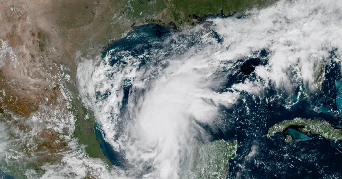
As of the 10 a.m. CDT advisory, the Hurricane Center expected Tropical Storm Isaias to become a hurricane by Thursday and approach the northern Gulf Coast.

Key points
- The National Hurricane Center's Advisory 4 on Tropical Storm Isaias, issued at 10 a.m. CDT Wednesday, put a Hurricane Watch on the northern Gulf Coast from Bay St. Louis, Mississippi, to Indian Pass, Florida. It also issued a Storm Surge Watch from the mouth of the Mississippi River to Yankeetown, Florida.
- At 10 a.m. CDT Isaias was in the Bay of Campeche, about 540 miles south-southwest of the mouth of the Mississippi, with winds near 45 mph. The Hurricane Center forecast rapid strengthening and expected it to become a hurricane by Thursday.
- As of that advisory, tropical storm conditions could begin in the watch areas midday Friday and hurricane conditions late Friday. The advisory gave peak surge of 5 to 7 feet from Ocean Springs to Indian Pass and in Mobile Bay, with 3 to 6 inches of rain and local totals up to 10.
Isaias: the first watches for the northern Gulf Coast
Isaias was named in the far southwest corner of the Gulf. By Wednesday morning an Air Force Reserve Hurricane Hunter crew had found its center near 22.4 north, 93.6 west. It was moving east-northeast at 8 mph, with top winds near 45 mph and a central pressure of 1000 millibars. That is still a long way from anyone's porch. The Weather Service office in Mobile put it about 660 miles south-southwest of Mobile, and the Tallahassee office put it about 720 miles southwest of Panama City.
What changed Wednesday is the forecast. As of the 10 a.m. CDT advisory, the Hurricane Center expected Isaias to turn northeast and then north on Thursday and Friday. It would pass north of the Yucatan Peninsula on Thursday and approach the U.S. northern Gulf Coast on Friday. The advisory said "rapid strengthening is forecast over the next day or two." A watch, in the Hurricane Center's own words, "is typically issued 48 hours before the anticipated first occurrence of tropical-storm-force winds."
The local offices added their own detail. Tallahassee wrote that the wind field "is expected to expand considerably and may be lopsided towards the east." It said conditions "could begin to deteriorate across the Panhandle as early as Friday morning." It also noted that the ground there is already wet from the past week's rain. Mobile expected 3 to 6 inches of rain, with local amounts up to 10 near the coast. It said the setup favors tornadoes east of the track as the storm moves inland Friday through Saturday. New Orleans named Friday into Saturday as the most likely time for impacts. All four offices wrote that there is still real uncertainty in the track and the timing.
The advisory also said more watches and warnings "could be required for a portion of the U.S. northern Gulf coast later today."
| Item | Detail (NHC Advisory 4, 10 a.m. CDT Wed Oct 7) |
|---|---|
| Center | 22.4N 93.6W, found by an Air Force Reserve Hurricane Hunter aircraft |
| Distance | About 540 mi SSW of the mouth of the Mississippi River; about 260 mi WNW of Progreso, Mexico |
| Max sustained winds | 45 mph; tropical-storm-force winds extend up to 45 mi from the center |
| Pressure | 1000 mb (29.53 in), from Air Force dropsonde data |
| Movement | ENE, 70 degrees, 8 mph; forecast to turn NE and N Thursday and Friday |
| Hurricane Watch | Bay St. Louis, MS to Indian Pass, FL |
| Tropical Storm Watch | Jefferson/Plaquemines Parish line, LA to west of Bay St. Louis; east of Indian Pass to Aucilla River, FL |
| Storm Surge Watch | Mouth of the Mississippi River to Yankeetown, FL |
| Wind timing | Tropical storm conditions could begin midday Friday; hurricane conditions late Friday |
| Rain, Fri through weekend | 3 to 6 in, local totals up to 10 in, far SE Louisiana to the Florida Panhandle; 1 to 3 in, locally up to 5 in, as far north as the Tennessee Valley and the Carolinas |
| Peak surge, if it arrives at high tide | Height above ground |
|---|---|
| Ocean Springs, MS to Indian Pass, FL | 5 to 7 ft |
| Mobile Bay | 5 to 7 ft |
| Mouth of the Mississippi River to Ocean Springs, MS | 3 to 5 ft |
| Indian Pass to Aucilla River, FL | 3 to 5 ft |
| Aucilla River to Yankeetown, FL | 2 to 4 ft |
| Lake Pontchartrain | 1 to 3 ft |
| Office | Statement issued | Watches it lists |
|---|---|---|
| NWS Mobile | 11:32 a.m. CDT | Hurricane and Storm Surge Watch: Mobile, Baldwin, Escambia, Santa Rosa and Okaloosa coastal zones; Hurricane Watch inland in the same five counties |
| NWS New Orleans | 10:49 a.m. CDT | Hurricane and Storm Surge Watch: Southern Harrison, Southern Jackson; Tropical Storm and Storm Surge Watch: Eastern Orleans, Lower Plaquemines, Lower St. Bernard, Southeast St. Tammany, Southern Hancock; Storm Surge Watch: Upper St. Bernard |
| NWS Tallahassee | 11:27 a.m. EDT | Hurricane and Storm Surge Watch: Coastal Bay, Coastal Gulf, South Walton; Tropical Storm and Storm Surge Watch: Coastal Franklin, Jefferson, Wakulla; Storm Surge Watch: Coastal Dixie, Taylor |
| NWS Tampa Bay | 11:23 a.m. EDT | Storm Surge Watch: Coastal Levy, peak surge up to 4 ft from the Suwannee River to Yankeetown |
*Sources: National Hurricane Center Tropical Storm Isaias Public Advisory 4, 10 a.m. CDT Wednesday; NWS Tropical Cyclone Local Statements from Mobile, New Orleans, Tallahassee and Tampa Bay, as issued. This is a forecast, not a measurement.*
What the offices ask of people in the watch
The Tampa Bay office's statement said it plainly: "Now is the time to check your emergency plan and emergency supplies kit." It also said not to "focus on the exact forecast track since hazards such as flooding rain, damaging wind gusts, storm surge, and tornadoes extend well away from the center of the storm." On evacuations, every office said the same thing: follow the advice of local officials. The federal preparedness guide is at https://www.ready.gov/hurricanes.
This is a summary, not emergency information. For live warnings see weather.gov and your local officials. The National Hurricane Center: https://www.nhc.noaa.gov/
The rock's live forecast for the places in this story
More from the Journal
 THE WEATHER BEAT
Watch, advisory, warning: how Monday's rain in Panama City climbed the Weather Service's three flood words
OCT 5
THE WEATHER BEAT
Watch, advisory, warning: how Monday's rain in Panama City climbed the Weather Service's three flood words
OCT 5
 THE WEATHER BEAT
The Missouri falls out of flood as eastern Iowa rivers keep rising; Wapsipinicon near DeWitt crests Thursday
OCT 5
THE WEATHER BEAT
The Missouri falls out of flood as eastern Iowa rivers keep rising; Wapsipinicon near DeWitt crests Thursday
OCT 5
 EXPLAINERS
Why Is the Sky Blue?
AUG 20
EXPLAINERS
Why Is the Sky Blue?
AUG 20
Follow the Journal: RSS · get it by email