THE WEATHER BEAT · OCT 5
Flash flood warnings overnight from Destin to Dothan and southwest Georgia, with Flood Watches until Monday evening
Radar put 3 to 6 inches over Coffee and Dale counties in Alabama by early Monday, and Flood Watches in north Florida and south Georgia run to 8 p.m. EDT.

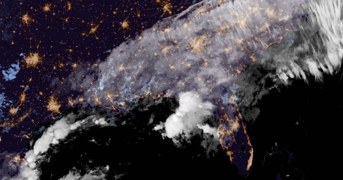
Key points
- Early Monday the National Weather Service issued Flash Flood Warnings for ten counties in southeast Alabama, southwest Georgia and the Florida Panhandle. Radar put 3 to 6 inches over central Coffee and northwestern Dale counties in Alabama by 4:24 a.m. CDT.
- Flood Watches from NWS Tallahassee and NWS Jacksonville run until 8 p.m. EDT Monday. Tallahassee now forecasts 2 to 4 more inches, with locally up to 6. On Sunday morning its watch had allowed up to 10.
- Two rivers are forecast to pass flood stage. The Shoal River near Crestview, Florida, is forecast to crest at 8.4 feet Tuesday morning, and the St. Marys River at Macclenny at 14.0 feet Tuesday evening.
Overnight into Monday, the Wiregrass and the Emerald Coast
Sunday's rain in Louisiana moved east overnight. Before dawn on Monday it settled over the corner where Alabama, Georgia and Florida meet.
The first warning came at 4:42 a.m. EDT. NWS Tallahassee warned Henry County and east central Dale County in Alabama, along with Clay, Quitman and Randolph counties in Georgia. The warning named Abbeville, Fort Gaines and Cuthbert, as well as Walter F. George Lake on the state line. Radar estimated 1 to 3 inches had already fallen and showed rates of 1.5 to 4 inches in an hour.
Just west of there the totals were higher. At 4:24 a.m. CDT, NWS Tallahassee's Flood Advisory for central Coffee and northwestern Dale counties said radar showed 3 to 6 inches had fallen around Elba, Enterprise and Ozark. At 6:20 a.m. EDT a Flash Flood Warning followed for parts of Coffee, Dale, Geneva, Henry and Houston counties. It named Dothan, Daleville, Fort Rucker and Headland, estimated 2 to 4 inches so far and said 2 to 4 more were possible.
On the coast, at 5:45 a.m. CDT, NWS Mobile warned southern Okaloosa and southeastern Santa Rosa counties in Florida. Radar and automated rain gauges showed 2 to 3 inches had fallen "in and around Destin and Okaloosa Island," and the warning named Fort Walton Beach, Niceville and Navarre. Farther east, a Tallahassee Flood Advisory at 6:03 a.m. EDT reported 1 to 2 inches around Panama City and Lynn Haven, with water over roadways.
| Product | Office, issued | Until | Radar rain so far | More possible |
|---|---|---|---|---|
| Flash Flood Warning: Henry and Dale AL; Clay, Quitman and Randolph GA | Tallahassee, 4:42 a.m. EDT | 7:45 a.m. EDT | 1 to 3 in | 1 to 3 in |
| Flood Advisory: central Coffee and NW Dale AL | Tallahassee, 4:24 a.m. CDT | 7:30 a.m. CDT | 3 to 6 in | 1 to 2 in |
| Flash Flood Warning: southern Okaloosa and SE Santa Rosa FL | Mobile, 5:45 a.m. CDT | 8:45 a.m. CDT | 2 to 3 in (radar and gauges) | 1 to 2 in |
| Flood Advisory: Bay, Gulf, Walton and Washington FL | Tallahassee, 6:03 a.m. EDT | 8:00 a.m. EDT | 1 to 2 in | 1 to 3 in |
| Flash Flood Warning: Coffee, Dale, Geneva, Henry and Houston AL | Tallahassee, 6:20 a.m. EDT | 9:15 a.m. EDT | 2 to 4 in | 2 to 4 in |
| Flood Advisory: Henry and Houston AL; Calhoun, Clay, Dougherty, Early, Lee, Randolph and Terrell GA | Tallahassee, 6:53 a.m. EDT | 10:00 a.m. EDT | 2 to 3 in | 1 to 3 in |
*Source: NWS Tallahassee and Mobile products as issued early Monday, October 5, read at 11:38Z. The rain figures are the offices' radar estimates (Mobile's also uses automated gauges), not measured storm totals.*
Today, officially
The watches still cover a wide area. NWS Tallahassee's Flood Watch, issued at 2:34 p.m. EDT Sunday, runs until 8 p.m. EDT Monday. It covers Geneva and Houston counties in Alabama, the Florida Panhandle and Big Bend, and much of southwest Georgia. It forecasts "2 to 4 inches for most of the area with locally higher amounts of up to 6 inches possible through Monday, especially along the Emerald and Forgotten Coasts." That is lower than the office's Sunday morning watch, which had allowed up to 10. The office again pointed to south-central Georgia, where rain "since Friday afternoon has primed the region."
NWS Jacksonville's watch, issued at 2:17 a.m. EDT Monday, also runs until 8 p.m. EDT. It covers northeast Florida, including Duval and Nassau counties, and southeast Georgia from Coffee and Ware counties to the coast at Glynn and Camden. It warns that "additional rainfall up to 3 inches over already saturated grounds may lead to flash flooding." NWS Mobile's watch for Mobile and Baldwin counties in Alabama and Escambia, Santa Rosa and Okaloosa in Florida runs through noon CDT.
The rivers are slower. In Sunday morning's product, the Shoal River near Crestview was forecast to crest at 8.9 feet early Tuesday afternoon. In NWS Mobile's 8:48 p.m. CDT Sunday update, the river stood at 5.6 feet and was forecast to pass its 8.0 foot flood stage late Monday evening and crest at 8.4 feet Tuesday morning. That matches its crest of 8.4 feet on April 26, 2020. The St. Marys River at Macclenny, on the Florida and Georgia line, stood at 10.2 feet at 7:45 p.m. EDT Sunday. NWS Jacksonville forecasts it to pass its 12.0 foot flood stage late Monday morning and crest at 14.0 feet Tuesday evening. The office says that at 14.0 feet, water covers the lower half of St. Mary's River Bluff Road, which cuts off 15 to 20 homes on the Georgia side.
The Storm Prediction Center's day 1 outlook, as read at 7:38 a.m. EDT, says: "Severe storms are unlikely today."
| Product | Office, issued | In effect until | What it says |
|---|---|---|---|
| Flood Watch: SE Alabama, Panhandle, Big Bend, SW Georgia | Tallahassee, 2:34 p.m. EDT Sun | 8 p.m. EDT Mon | 2 to 4 in more, locally 6 |
| Flood Watch: NE Florida and SE Georgia | Jacksonville, 2:17 a.m. EDT Mon | 8 p.m. EDT Mon | up to 3 in more on saturated ground |
| Flood Watch: SW Alabama and NW Florida | Mobile, 9:58 p.m. CDT Sun | noon CDT Mon | 1 to 3 in more, locally 5 |
| Flood Warning: Shoal River near Crestview | Mobile, 8:48 p.m. CDT Sun | 1 p.m. CDT Thu | crest 8.4 ft Tue morning; flood stage 8.0 ft |
| Flood Warning: St. Marys River at Macclenny | Jacksonville, 8:48 p.m. EDT Sun | until further notice | crest 14.0 ft Tue evening; flood stage 12.0 ft |
| SPC day 1 outlook | Storm Prediction Center | today | severe storms unlikely |
*Source: NWS Tallahassee, Jacksonville and Mobile products and the SPC day 1 outlook, read at 11:38Z October 5. SPC preliminary storm reports and the WPC excessive rainfall outlook did not load for this desk today, so neither is cited.*
Sunday's story covered the first day of this rain, in Louisiana. The Weather School's lesson on watches, warnings and advisories explains how a watch overnight becomes a warning by morning.
This is a morning summary, not emergency information. For live warnings see weather.gov and your local officials, and for river forecasts see water.noaa.gov.
The rock's live forecast for the places in this story
More from the Journal

Follow the Journal: RSS · get it by email