THE WEATHER BEAT · OCT 10
Montana under Winter Storm Warnings from three offices, with up to 20 inches of heavy, wet snow on the Rocky Mountain Front
Great Falls, Billings and Missoula issued Winter Storm Warnings for Saturday into Monday: 10 to 20 inches on the Front, wet snow on trees still in leaf.

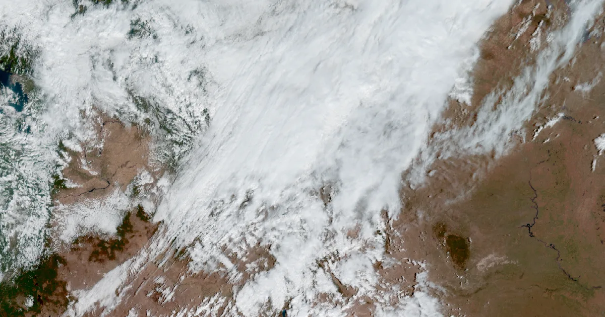
Key points
- Three National Weather Service offices in Montana (Great Falls, Billings and Missoula) have Winter Storm Warnings out from Saturday into Monday morning. The heaviest totals forecast are 10 to 20 inches along the Rocky Mountain Front and in the Glacier Park region.
- On the plains the snow is forecast to be heavy and wet. The Great Falls office is worried about trees that still have their leaves, which could lose branches and bring down power lines.
- The Monday morning commute is named in the Billings warnings. Advisories with 2 to 6 inches reach Livingston, Big Timber, Bozeman Pass and the Helena Valley.
Today, officially
Montana went from summer to snow in about a day. NWS Billings put it plainly in its 5:07 a.m. MDT discussion on Saturday: the early morning cold front "will finally rid us of the hot and dry air mass we have dealt with for most of the past week." By the afternoon, three forecast offices had Winter Storm Warnings running from the Canadian border down to Butte and Cooke City.
The biggest numbers belong to NWS Great Falls. Its 10:56 a.m. MDT warnings call for 10 to 20 inches of heavy, wet snow along the Southern Rocky Mountain Front, the Southern High Plains, the East Glacier Park region and the Northern High Plains, through 6 a.m. MDT Monday. The office says isolated amounts could approach 30 inches in the Bob Marshall Wilderness. Out on the plains, Cascade County below 5,000 feet, Judith Basin County, the Meagher County valleys and eastern Pondera and Teton counties have 7 to 14 inches in their warning.
The snow's weight is what worries the forecasters. The Great Falls discussion issued at 12:42 p.m. MDT says the snow should be "of the wet and heavy variety, especially at lower elevations, which raises concern for trees with leaves on them still seeing snapped branches, potentially impacting power lines." Every Great Falls warning says isolated power outages are possible.
There is a real October wrinkle here too. The same discussion says totals "will vary drastically from grassy/elevated surfaces to roadways/paved surfaces given relatively warm ground temperatures and the effects of a higher October sun angle." It also says plains temperatures along and west of I-15 had already dropped into the mid to upper 30s, cold enough for snow to start sticking to roads by late afternoon.
Farther south, NWS Billings issued its warnings at 1:38 p.m. MDT. They call for 10 to 18 inches in the Absaroka, Beartooth and Crazy Mountains, where the office says travel into Cooke City will be affected. Judith Gap gets 4 to 8 inches with gusts to 40 mph, and the Melville Foothills get 5 to 10 inches. Both warnings name US-191 and the Monday morning commute. NWS Missoula's 11:42 a.m. MDT warning covers the Butte and Blackfoot region with 3 to 9 inches, 12 to 18 in the higher mountains, and gusts to 45 mph, over MacDonald Pass, Homestake Pass, Georgetown Lake, Butte and Highway 12 from Garrison to Elliston.
The storm also picks up a tropical leftover. Great Falls writes that the upper trough interacts "with the remnants of Rachel as they lift northeastward," and that the extra moisture should spread snow into southwest Montana on Sunday. Rachel is the Pacific storm that put San Diego County under a Tropical Storm Watch on Friday. Missoula adds that models "continue to show spread" on how far west that moisture gets. If it tracks farther west, grassy surfaces in the lower valleys of west-central and southwest Montana could see more snow. Once the snow ends, Billings says many places could get their first freeze of the season Sunday night or Monday night.
| Office, issued (MDT, Sat Oct 10) | Area | Snow | Gusts | Ends |
|---|---|---|---|---|
| Great Falls, 10:56 a.m. | S. Rocky Mountain Front, S. High Plains, Upper Blackfoot and MacDonald Pass, Gates of the Mountains | 10 to 20 in (Lincoln valley up to 7; isolated near 30 in the Bob Marshall) | 45 mph | 6 a.m. Mon |
| Great Falls, 10:56 a.m. | East Glacier Park region, Northern High Plains | 10 to 20 in | 50 mph | 6 a.m. Mon |
| Great Falls, 10:56 a.m. | Cascade Co. below 5,000 ft, Judith Basin Co. and Judith Gap, Meagher Co. valleys, E. Pondera and E. Teton | 7 to 14 in | 35 mph | 6 a.m. Mon |
| Great Falls, 10:56 a.m. | Big Belt, Bridger and Castle Mountains | 6 to 14 in | 40 mph | 6 a.m. Mon |
| Great Falls, 10:56 a.m. | Little Belt, Highwood, Snowy, Judith, Elkhorn and Boulder Mountains | 6 to 12 in | 45 mph | 6 a.m. Mon |
| Billings, 1:38 p.m. | Absaroka/Beartooth and Crazy Mountains | 10 to 18 in | 35 mph | noon Mon |
| Billings, 1:38 p.m. | Melville Foothills | 5 to 10 in | 35 mph | noon Mon |
| Billings, 1:38 p.m. | Judith Gap | 4 to 8 in, near a foot in the mountains | 40 mph | noon Mon |
| Missoula, 11:42 a.m. | Butte/Blackfoot region | 3 to 9 in, 12 to 18 higher up | 45 mph | 6 a.m. Mon |
| Billings, 1:38 p.m. (advisory) | Livingston area, N. Park, Beartooth Foothills, N. Sweet Grass, S. Wheatland | 2 to 6 in | 40 mph | noon Mon |
| Great Falls, 10:56 a.m. (advisory) | Helena Valley, Gallatin Valley, Madison River Valley and others | 2 to 5 in lower, 5 to 8 mountains | 50 mph | 6 a.m. Mon |
Source: NWS Winter Storm Warnings and Winter Weather Advisories from Great Falls, Billings and Missoula, and the Area Forecast Discussions from Great Falls (12:42 p.m. MDT), Missoula (12:48 p.m. MDT) and Billings (5:07 a.m. MDT), all Saturday, October 10. Amounts are forecasts as issued, not measurements.
This is a morning summary, not emergency information. For live warnings see weather.gov and your local officials: https://www.weather.gov/tfx/, https://www.weather.gov/byz/, https://www.weather.gov/mso/
The rock's live forecast for the places in this story
More from the Journal
 THE WEATHER BEAT
Isaias becomes a hurricane overnight as warnings go up from Ocean Springs to Panama City Beach
OCT 8
THE WEATHER BEAT
Isaias becomes a hurricane overnight as warnings go up from Ocean Springs to Panama City Beach
OCT 8
 THE WEATHER BEAT
Flood Watch for Kauai, Niihau and Oahu from Wednesday evening into Thursday as southerly winds draw up tropical moisture
OCT 7
THE WEATHER BEAT
Flood Watch for Kauai, Niihau and Oahu from Wednesday evening into Thursday as southerly winds draw up tropical moisture
OCT 7
 EXPLAINERS
Why Is the Sky Blue?
AUG 20
EXPLAINERS
Why Is the Sky Blue?
AUG 20
Follow the Journal: RSS · get it by email