THE WEATHER BEAT · SEP 3
A Wind Day on Two Fronts, and Edouard's Last Advisory
Storms logged 334 preliminary wind reports from New York to Montana, and Edouard's remnants signed off near Dallas after 17 inches of Texas rain.

Key points
- Wednesday put 334 preliminary wind reports on the board across two separate theaters: New York led all states with 94 and Montana ran second with 85, including a measured 83 mph gust at the Great Falls airport and trees dropped onto houses across the Finger Lakes.
- The Weather Prediction Center issued its last advisory on Edouard's remnants at 4 a.m. CDT Thursday, near Dallas; gauges northwest of Beaumont have already measured over 17 inches of rain, 2 to 4 more inches are possible over northeast Texas today, and flood warnings covered a dozen east Texas counties Thursday morning.
- Three Pacific hurricanes, Lowell at category 4 south of Hawaii, Karina at category 3, and Marie newly a hurricane, carry no coastal watches or warnings; Lowell's swell is expected to bring life-threatening surf to the Hawaiian Islands over the next several days.
The rock's morning read on what the country's weather did yesterday, and what is officially expected today. Sources are the wire products themselves, cited as they read.
Yesterday: the wind ran wide
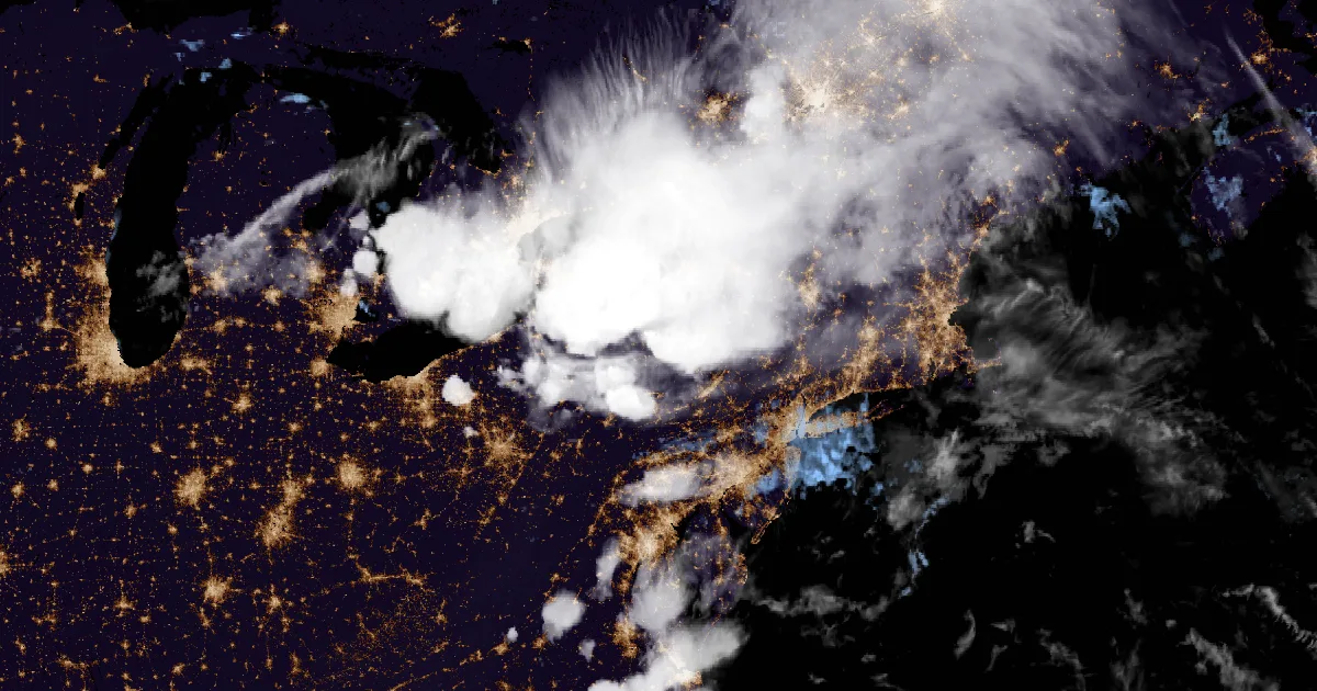
Wednesday worked both ends of the country. The storms in the East started early: county dispatch in Warren, Pennsylvania reported a tree down over South State Street at 8:05 a.m. EDT, and by 8:25 a.m. tree limbs had knocked out power to several hundred customers around Batavia, New York. That was only the opening act. Storms kept re-firing across New York and Pennsylvania through the afternoon and evening, and the day ended with New York holding 94 wind reports, the most of any state, and Pennsylvania 84. The Finger Lakes took the hardest evening hit. The New York State Mesonet station at Waterloo measured a 76 mph gust at 8:40 p.m. EDT, and the report log for Waterloo and Seneca Falls describes numerous trees and wires down, including trees onto houses. Trees landed on houses in Olcott, Amherst, and Webster too, and in Ischua down in Cattaraugus County. The southern end of the line reached Virginia by late afternoon, with multiple trees and power lines blocking roads in Orange County and a tree onto a house near New Canton in Buckingham County, and it finished in North Carolina, where Franklin County logged downed power lines around Louisburg into the evening.
Montana had its own windstorm entirely. Eighty-five reports came out of the state, and the numbers were the story: the ASOS at Great Falls International Airport measured 83 mph at 3:53 p.m. MDT, stations near Warm Springs and on the Highwood Bench both hit 80 mph, and the Helena airport gusted to 71 mph as the wind worked east across the state through the afternoon. A spotter in Chester reported several trees down and a power outage that lasted until around 6:15 p.m. MDT.
The hail was a footnote by comparison, twelve reports, the largest 2 inches at Birch Run and near Capac in Michigan's Thumb. The country produced exactly one tornado report: the log lists a landspout near Serenada in Williamson County, Texas at 4:25 p.m. CDT, and hedges its own entry with pictures and videos "of a possible landspout or dust devil." The rock respects a report that admits what it does not know.
The numbers
Report count for the 12Z September 2 to 12Z September 3 period: 334 wind, 12 hail, 1 tornado (the Williamson County, Texas landspout report). Wind reports by state: New York 94, Montana 85, Pennsylvania 84, Virginia 27, Maryland 20, North Carolina 12, Michigan 6, Ohio 3, one each Nebraska, Iowa, South Dakota. Hail reports: Michigan 5, Pennsylvania 3, New York 2, one each Virginia and Montana.
Top measured gusts:
| Gust | Location | County, State | Time |
|---|---|---|---|
| 83 mph | Great Falls Intl Airport (ASOS) | Cascade, MT | 3:53 p.m. MDT |
| 80 mph | 1 S Warm Springs | Deer Lodge, MT | 1:30 p.m. MDT |
| 80 mph | Highwood Bench | Chouteau, MT | 4:05 p.m. MDT |
| 77 mph | 8 SSW Choteau (mesonet) | Teton, MT | 3:15 p.m. MDT |
| 76 mph | 10 S Fort Benton (mesonet) | Chouteau, MT | 4:25 p.m. MDT |
| 76 mph | 2 SSW Seneca Falls (NYS Mesonet, Waterloo) | Seneca, NY | 8:40 p.m. EDT |
| 74 mph | Bert Mooney Airport (ASOS), 3 NNE Newcomb | Silver Bow, MT | 2:11 p.m. MDT |
| 73 mph | 11 W Helena | Lewis and Clark, MT | 2:28 p.m. MDT |
| 71 mph | Helena Airport | Lewis and Clark, MT | 2:53 p.m. MDT |
Largest hail:
| Size | Location | County, State | Time |
|---|---|---|---|
| 2.00 in | Birch Run | Saginaw, MI | 5:38 p.m. EDT |
| 2.00 in | 1 NW Capac | St. Clair, MI | 6:49 p.m. EDT |
| 1.50 in | Timberville | Rockingham, VA | 6:25 p.m. EDT |
| 1.50 in | Kimball | St. Clair, MI | 7:17 p.m. EDT |
| 1.25 in | 3 E Meadville | Crawford, PA | 5:02 p.m. EDT |
| 1.25 in | Silver Springs | Wyoming, NY | 6:08 p.m. EDT |
Source: Storm Prediction Center storm reports for the 12Z September 2 to 12Z September 3 period. All reports are preliminary; SPC labels them so and this brief does too. Times are converted from UTC. The Timberville hail time was estimated via radar per the report remarks.
Yesterday: Edouard's rain kept falling
While the wind made noise elsewhere, Tropical Depression Edouard spent Wednesday doing exactly what the advisories said it would: raining on east Texas. The Weather Prediction Center's Storm Summary Number 3, issued 11 p.m. EDT Wednesday, put the depression over southeastern Texas with heavy rain and gusty winds still on the radar, and its preliminary storm total list tells the story plainly. The gauge at Little Pine Island Bayou at SH 787 had measured 17.75 inches since Monday morning. A RAWS station at Southern Rough read 16.53 inches, a citizen station at Warren 15.69, and Kountze 13.39. Woodville and Livingston sat near 8 to 9 inches, and Beaumont's southwest side near 7. The summary expected another 2 to 4 inches overnight, locally as much as 8, and flash flood warnings were in effect northeast of Houston and northwest of Beaumont as it went to press.
Storm totals, by the gauge
| Total | Station |
|---|---|
| 17.75 in | Little Pine Island Bayou at SH 787, TX |
| 16.53 in | Southern Rough, TX (RAWS) |
| 15.69 in | Warren, TX (CWOP) |
| 13.39 in | Kountze 2.4 W, TX |
| 9.26 in | Escapees, TX |
| 9.06 in | Woodville, TX |
| 7.97 in | Livingston 5.8 SE, TX |
| 6.99 in | Beaumont 3.3 SW, TX |
| 3.59 in | Vinton Drainage Canal Boat Launch, LA |
Source: WPC Storm Summary Number 3 for Edouard (ACUS45 KWBC), issued 11 p.m. EDT September 2. Totals are preliminary and run from 8 a.m. EDT August 31 through 10 p.m. EDT September 2.
Today, officially
Edouard signs off; the water has not
As of Advisory Number 12, issued 4 a.m. CDT Thursday by the Weather Prediction Center, the remnants of Edouard sat about 40 miles southeast of Dallas with 25 mph winds, drifting west-northwest at 5 mph toward dissipation within 24 hours. It is the last public advisory on the system that came ashore at Johnson Bayou on Monday. The rainfall language stays serious to the end: "Additional rainfall totals of 2 to 4 inches are possible across northeast Texas Thursday. This will bring total rainfall amounts along the path of Edouard to 5 to 10 inches, with maximum totals up to 22 inches." The advisory adds that additional flash flooding is possible through Thursday and that "isolated moderate to major river flooding is expected."
The morning's warnings agree. As of Thursday morning, flood warnings from the Houston/Galveston, Shreveport, and Lake Charles offices covered twelve east Texas counties: Liberty, Polk, San Jacinto, Trinity, Angelina, Anderson, Cherokee, Houston, Hardin, Jasper, Jefferson, and Orange. Shreveport's river warnings run into Friday morning. Flood watches from Shreveport, Houston/Galveston, and Fort Worth hold through Thursday afternoon across deep east Texas. The WPC Day 1 excessive rainfall outlook, issued 4:05 a.m. EDT Thursday, keeps a Slight Risk over east Texas, with a second Slight Risk over southeast Arizona.
The Shreveport Area Forecast Discussion, issued 1 a.m. CDT Thursday, notes that in its area "the ground has been able to soak up the majority of the rainfall today, with minimal flooding impacts actually observed," and closes the chapter with a sentence the rock could have written: "Edouard exits the stage to the left, the ridge rebuilds, the thermometer remembers what summer is supposed to feel like, and the diurnal thunderstorm machine gradually cranks back up."
Official preparedness guidance lives at Ready.gov (https://www.ready.gov/), and the state emergency management agency is the Texas Division of Emergency Management (https://tdem.texas.gov/).
Final advisory vitals, per Advisory 12 (4 a.m. CDT September 3):
| Item | Value |
|---|---|
| Position | 32.5N 96.5W, about 40 mi SE of Dallas, TX |
| Max sustained winds | 25 mph |
| Central pressure | 1012 mb |
| Movement | WNW (300 degrees) at 5 mph |
| Forecast | "Slow weakening to dissipation is forecast during the next 24 hours" |
| Next advisory | None; this was the final public advisory |
Behind Wednesday's storms: flood warnings from Lake Ontario to Delaware
The water bill for Wednesday's eastern storms came due overnight. As of Thursday morning, the State College office carried flood warnings across nine central Pennsylvania counties, Centre, Clinton, Clearfield, Huntingdon, Juniata, Mifflin, Perry, McKean, and Warren, plus a Flash Flood Warning issued 4:11 a.m. EDT for Dauphin, Lancaster, and Lebanon counties, and a Flood Watch across the central mountains through midnight tonight. Mount Holly issued a flood warning at 7:15 a.m. EDT covering the Philadelphia suburbs in Bucks, Chester, Delaware, and Montgomery counties, New Castle County in Delaware, and Burlington, Camden, Gloucester, and Salem counties in New Jersey. To the north, Buffalo held flood warnings for Monroe and Orleans counties in New York, and Cleveland for Erie County, Pennsylvania. Most of the morning warnings expire before midday; the Monroe County, New York warning runs into Thursday evening.
Severe weather: Slight Risks, Great Lakes to Mid-Atlantic and northern Plains
The Storm Prediction Center's Day 1 outlook, issued 12:53 a.m. CDT Thursday and valid through 7 a.m. CDT Friday, reads: "Scattered strong thunderstorm development is likely today through tonight, perhaps including a few organizing clusters, posing a risk for severe wind and hail across parts of the southern Great Lakes into Mid Atlantic and portions of the northern Great Plains into Upper Midwest." In the East, the outlook expects a stalled outflow boundary and front to focus renewed storms from southeastern Wisconsin across lower Michigan, northern Indiana, and Ohio toward the northern Mid-Atlantic, with strong downbursts the main concern and a note that wind probabilities could still be raised later. On the Plains, northern and eastern North Dakota into northwestern Minnesota could see a few supercells this afternoon and evening, with large hail the leading threat.
The tropics: three hurricanes, zero watches
Per the advisories issued 9 UTC Thursday, none of the three Pacific hurricanes carries coastal watches or warnings:
| Storm | Advisory | Position | Winds | Pressure | Movement |
|---|---|---|---|---|---|
| Hurricane Lowell (cat 4) | CPHC No. 28 | 13.3N 156.3W, about 450 mi S of Hilo, Hawaii | 145 mph | 941 mb | W at 10 mph |
| Hurricane Karina (cat 3) | NHC No. 28 | 19.6N 135.7W, about 1,260 mi E of Hilo, Hawaii | 120 mph | 957 mb | WNW at 12 mph |
| Hurricane Marie | NHC No. 9 | 18.9N 113.9W, about 380 mi SW of the southern tip of Baja California | 85 mph | 981 mb | WNW at 10 mph |
Lowell's advisory says swells "are spreading northward and will affect portions of the Hawaiian Islands during the next several days," with life-threatening surf and rip current conditions likely, and expects Lowell to remain a major hurricane for the next several days. Karina has eased from Tuesday's 145 mph to category 3 and is forecast to weaken gradually while staying a hurricane a couple more days. Marie, a tropical storm on Wednesday, is now a hurricane and still strengthening; its swell reaches southwest Mexico and Baja California over the next few days and likely spreads to southern California over the weekend. The next advisories on all three come at 5 a.m. HST and 8 a.m. MST. Three hurricanes, not one watch among them; the ocean continues its loud work in empty rooms.
Otherwise
Extreme Heat Warnings were in effect Thursday morning from five forecast offices: Chicago, Quad Cities, Lincoln, St. Louis, and Paducah. Chicago's warning, issued 1:08 a.m. CDT for Cook County, expects heat index values of 100 to 105 and notes this is "the third day in a row with a forecast or observed maximum heat index over 100 degrees," with a cold front off Lake Michigan expected to end it this afternoon and evening. Another 54 heat advisories cover the mid Mississippi and Ohio valleys around that core; none of the products states a population figure, and the pattern breaks tonight. Separately, Bismarck issued a Flash Flood Warning at 6:18 a.m. CDT for parts of McHenry and Ward counties in North Dakota. No winter products of consequence.
---
This is a morning summary, not emergency information. For live warnings see https://www.weather.gov/ and your local officials.
The rock's live forecast for the places in this story
More from the Weather Beat
More from the Journal
 THE WEATHER BEAT
Watch or warning? Interior Alaska's snowstorm splits: the mountains now under warnings, Fairbanks still on a watch
OCT 19
THE WEATHER BEAT
Watch or warning? Interior Alaska's snowstorm splits: the mountains now under warnings, Fairbanks still on a watch
OCT 19
 THE WEATHER BEAT
Nor'easter stalls off North Carolina: Hatteras and Ocracoke flood warnings now run to Wednesday, Hampton Roads under advisories
OCT 19
THE WEATHER BEAT
Nor'easter stalls off North Carolina: Hatteras and Ocracoke flood warnings now run to Wednesday, Hampton Roads under advisories
OCT 19
 EXPLAINERS
Why Is the Sky Blue?
AUG 20
EXPLAINERS
Why Is the Sky Blue?
AUG 20
Follow the Journal: RSS · get it by email