THE WEATHER BEAT · SEP 2
Edouard Comes Ashore at Johnson Bayou
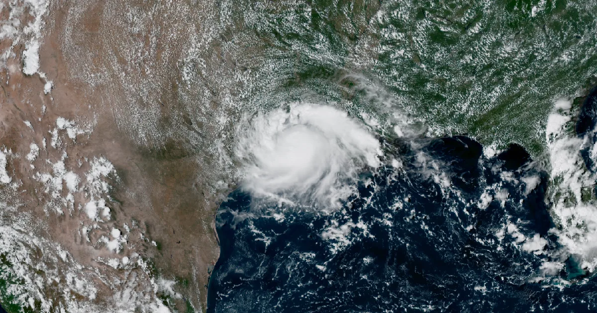
Edouard came ashore at Johnson Bayou at 60 mph, short of hurricane strength, and now crawls over east Texas where flash flooding is the day's story.

Key points
- Tropical Storm Edouard came ashore near Johnson Bayou, Louisiana at 2:20 p.m. CDT yesterday with 60 mph winds, short of hurricane strength; it is now a depression over east Texas, and today's story is the rain, with 4 to 8 inches forecast along its path and up to 12 possible.
- Yesterday was a loud severe weather day on two fronts: 137 preliminary wind reports and 35 hail reports nationwide, including a measured 98 mph gust in northeast Nebraska and a long evening of downed trees from Pennsylvania through New Jersey and Delaware.
- Two category 4 hurricanes, Karina and Lowell, are spinning in the Pacific with 145 mph winds each; neither carries coastal watches or warnings, though Lowell's swell is expected to reach Hawaii starting Wednesday.
The rock's morning read on what the country's weather did yesterday, and what is officially expected today. Sources are the wire products themselves, cited as they read.
Yesterday: Edouard came ashore
The wait ended Tuesday afternoon. At 2:20 p.m. CDT on September 1, radar out of Lake Charles and Houston put the center of Tropical Storm Edouard over the marsh at Johnson Bayou, Louisiana, just east of the Texas line. The National Hurricane Center's landfall update estimated maximum sustained winds at 60 mph and a central pressure of 996 mb. The near-hurricane the previous day's advisories had left room for never showed up; Edouard spent its morning holding at 50 mph, added a little strength in the final hours, and crossed the coast as a solid but ordinary tropical storm.
The wind did its loudest work right at the corner of the two states. The National Ocean Service station at Texas Point, Texas caught a sustained wind of 57 mph and a gust to 71 mph just before landfall, and Port Arthur gusted to 49 mph an hour later as the center passed close to the city. By 10 p.m. EDT, the Weather Prediction Center's first storm summary described a very compact storm crawling northwest at 7 mph, with its heaviest bands producing rain at 2 to 3 inches per hour. Overnight the center crossed into the Piney Woods of east Texas, and the Houston office estimated 6 to 8 inches had already fallen close to the core by 2 a.m. CDT.
Landfall, by the numbers
| Item | Value |
|---|---|
| Landfall | Near Johnson Bayou, LA, 2:20 p.m. CDT September 1 |
| Winds at landfall | 60 mph sustained, 996 mb |
| Peak measured gust | 71 mph, Texas Point, TX (NOS station TXPT2), shortly before landfall |
| Other gusts | 68 mph Port Arthur 2 NW, TX; 60 mph Bevil Oaks 4 NNW, TX; 59 mph Beaumont 2 SE, TX; 52 mph Cameron 3 SW, LA |
| Rain rates | 2 to 3 inches per hour in the strongest bands, per the 11 p.m. EDT storm summary |
Source: NHC Tropical Cyclone Updates for Edouard issued 2 p.m., 2:25 p.m., and 3 p.m. CDT September 1, and WPC Storm Summary Number 1, issued 11 p.m. EDT September 1. The gust list is that summary's preliminary selection.
Yesterday: a 98 mph gust in Nebraska and a treefall evening in the East
While the Gulf Coast watched Edouard, the two Slight Risk areas from Monday's outlooks both produced. The louder number came from the Plains. A Nebraska Mesonet station near Fordyce, in Cedar County, measured a 98 mph wind gust at 8:32 p.m. CDT. Minutes earlier a tractor trailer was tipped onto its side near the Highway 12 and US 81 junction, and 12 inch tree limbs came down across the town of Wynot. The same storms threw large hail across the Nebraska and South Dakota border country: stones to 2.75 inches at Pickstown, South Dakota at 5:18 p.m. CDT, and baseball size hail at Niobrara, Nebraska at 7:44 p.m. CDT that broke a vehicle windshield. The night ended in Minnesota, where an AWOS station at the Mayo Helipad in Rochester gusted to 68 mph at 1:35 a.m. CDT with large trees down and power outages.
The East's version was quieter per report and much wider. From about 6:12 p.m. EDT, when county dispatch in Meadville, Pennsylvania began reporting multiple trees and power lines down, storms worked southeast across Pennsylvania through the evening: Berks, Chester, Carbon, Lehigh, and Bradford counties fill page after page of the report log with trees on wires and closed roads. After dark the line reached Delaware and South Jersey. New Castle County, Delaware logged multiple roads closed by downed trees around Wilmington and Newark, and Gloucester and Salem counties in New Jersey reported numerous trees and power lines down, with Route 49 fully closed at Salem. Pennsylvania alone accounted for 58 of the day's wind reports.
The numbers
Report count for the 12Z September 1 to 12Z September 2 period: 137 wind, 35 hail, 0 tornado. Wind reports by state: Pennsylvania 58, New Jersey 16, South Dakota 14, Nebraska 11, Delaware 11, Iowa 8, Minnesota 7, Wisconsin 6, New York 3, one each Texas, Idaho, California. Hail reports: Nebraska 21, South Dakota 9, Minnesota 3, one each Iowa and New Jersey.
Top measured gusts:
| Gust | Location | County, State | Time |
|---|---|---|---|
| 98 mph | 4 NNE Fordyce | Cedar, NE | 8:32 p.m. CDT |
| 81 mph | 9 NNE Hawarden | Sioux, IA | 9:50 p.m. CDT |
| 73 mph | 2 NE George | Lyon, IA | 10:42 p.m. CDT |
| 71 mph | 5 SSE Rock Rapids | Lyon, IA | 10:37 p.m. CDT |
| 70 mph | 10 SE Mills | Keya Paha, NE | 3:58 p.m. CDT |
| 70 mph | 1 NW Wagner | Charles Mix, SD | 5:58 p.m. CDT |
| 70 mph | 3 SE Port Penn | marine zone ANZ430, DE | 8:55 p.m. EDT |
| 68 mph | Rochester (Mayo Helipad AWOS) | Olmsted, MN | 1:35 a.m. CDT |
Largest hail:
| Size | Location | County, State | Time |
|---|---|---|---|
| 2.75 in | Pickstown | Charles Mix, SD | 5:18 p.m. CDT |
| 2.75 in | Niobrara | Knox, NE | 7:44 p.m. CDT |
| 2.50 in | 8 WSW Pickstown | Gregory, SD | 4:53 p.m. CDT |
| 2.00 in | 8 WSW Springfield | Bon Homme, SD | 7:42 p.m. CDT |
| 2.00 in | Randolph | Cedar, NE | 9:59 p.m. CDT |
Source: Storm Prediction Center storm reports for the 12Z September 1 to 12Z September 2 period. All reports are preliminary; SPC labels them so and this brief does too. Several gusts came from personal weather stations per the report remarks; times are converted from UTC.
Today, officially
Edouard inland: the rain is the story now
As of Advisory Number 8, issued 4 a.m. CDT Wednesday by the Weather Prediction Center, Tropical Depression Edouard sat about 30 miles south-southwest of Lufkin, Texas, drifting north-northwest at 5 mph with 35 mph winds. The advisory expects Edouard to dissipate Wednesday night. Its rainfall language is direct: "Total rainfall along Edouard's path is expected to range from 4 to 8 inches, with maximum totals up to 12 inches for parts of the Upper Texas Coast inland through east-central Texas. This rainfall is likely to produce flash flooding, especially in low-lying and urban areas. Significant flash flooding is possible." A brief tornado or two remained possible through early Wednesday morning across parts of southwest Louisiana and southeast Texas.
The warnings on the ground Wednesday morning matched that language. Between 4:46 and 6:04 a.m. CDT, the Lake Charles and Houston offices issued Flash Flood Warnings covering Polk, San Jacinto, Liberty, Montgomery, Hardin, Tyler, Chambers, and Jefferson counties in Texas. Flood Watches from four forecast offices run through Wednesday afternoon and evening across east Texas, from the Houston metro north and east through the Piney Woods into the Fort Worth and Shreveport forecast areas.
The Houston Area Forecast Discussion, issued 1:59 a.m. CDT Wednesday, reads it this way: "The primary threat through tonight is heavy rainfall," with the highest risk "generally north of I-10 and along and east of I-45," and a forecast "swath of 6-8 inch rainfall totals in a SE to NW orientation from Northern Liberty to Houston County through Thursday." That discussion also notes WPC had upgraded portions of the Piney Woods to a Moderate Risk for excessive rainfall; the WPC Day 1 excessive rainfall outlook issued later, at 4:04 a.m. EDT and valid from 8 a.m. EDT Wednesday, carries a Slight Risk over east Texas. The two products read differently and are reported here as they read.
Official preparedness guidance lives at Ready.gov (https://www.ready.gov/), and the state emergency management agencies are the Texas Division of Emergency Management (https://tdem.texas.gov/) and Louisiana GOHSEP (https://gohsep.la.gov/).
Advisory vitals, per Advisory 8 (4 a.m. CDT September 2):
| Item | Value |
|---|---|
| Position | 30.8N 95.0W, about 30 mi SSW of Lufkin, TX |
| Max sustained winds | 35 mph |
| Central pressure | 1004 mb |
| Movement | NNW (335 degrees) at 5 mph |
| Forecast | "Continued weakening is expected over the next 24 hours, as Edouard is forecast to dissipate Wednesday night" |
| Next advisory | 10 a.m. CDT Wednesday |
Severe weather: Slight Risks east and west
The Storm Prediction Center's Day 1 outlook, issued 12:57 a.m. CDT Wednesday and valid through 7 a.m. CDT Thursday, carries two Slight Risk areas. As the summary reads: "Severe thunderstorms are possible across portions of the eastern Great Lakes to the Mid-Atlantic today and tonight. Damaging wind gusts are the main threat, though some large hail and a few tornadoes may also occur. Scattered severe gusts and more sporadic occurrences of large hail appear possible from the northern Rockies into northern High Plains Wednesday afternoon into night." In the East, the outlook describes a complex day of repeated storm rounds, with a possible greater tornado risk in the evening across southern New York and central Pennsylvania, "contingent upon air mass recovery" behind the morning storms. In Montana, the outlook expects a fast-moving line by late afternoon with scattered severe gusts likely and peak intensity of 65 to 80 mph possible.
The tropics: two category 4s, both far from land
Per the advisories issued 9 UTC Wednesday, none of the three Pacific storms carries coastal watches or warnings:
| Storm | Advisory | Position | Winds | Pressure | Movement |
|---|---|---|---|---|---|
| Hurricane Karina | NHC No. 24 | 18.5N 131.7W, about 1,440 mi W of the southern tip of Baja California | 145 mph | 940 mb | W at 12 mph |
| Hurricane Lowell | CPHC No. 24 | 13.5N 152.2W, about 470 mi SSE of Hilo, Hawaii | 145 mph | 941 mb | W at 12 mph |
| Tropical Storm Marie | NHC No. 5 | 16.7N 111.0W, about 435 mi S of the southern tip of Baja California | 65 mph | 994 mb | NW at 10 mph |
Lowell's advisory headline reads, "LOWELL FORECAST TO BE A POWERFUL HURRICANE FOR THE NEXT SEVERAL DAYS," and its hazards section says swells "are likely to affect portions of the Hawaiian Islands beginning on Wednesday" with life-threatening surf and rip current conditions likely. Marie is forecast to become a hurricane later today, with its swell reaching southwest Mexico and Baja California in the coming days and likely spreading to southern California over the weekend. Two 145 mph storms on the same map and not one watch between them: the ocean is doing loud things in empty rooms, and the rock approves.
Otherwise
Extreme Heat Warnings were in effect Wednesday morning from the Quad Cities and Paducah forecast offices, and heat advisories covered a broad stretch of the mid Mississippi and Ohio valleys, in ordinary early-September numbers and below this brief's bar for news. No winter products of consequence.
---
This is a morning summary, not emergency information. For live warnings see https://www.weather.gov/ and your local officials.
The rock's live forecast for the places in this story
More from the Weather Beat
More from the Journal
 THE WEATHER BEAT
Watch or warning? Interior Alaska's snowstorm splits: the mountains now under warnings, Fairbanks still on a watch
OCT 19
THE WEATHER BEAT
Watch or warning? Interior Alaska's snowstorm splits: the mountains now under warnings, Fairbanks still on a watch
OCT 19
 THE WEATHER BEAT
Nor'easter stalls off North Carolina: Hatteras and Ocracoke flood warnings now run to Wednesday, Hampton Roads under advisories
OCT 19
THE WEATHER BEAT
Nor'easter stalls off North Carolina: Hatteras and Ocracoke flood warnings now run to Wednesday, Hampton Roads under advisories
OCT 19
 EXPLAINERS
Why Is the Sky Blue?
AUG 20
EXPLAINERS
Why Is the Sky Blue?
AUG 20
Follow the Journal: RSS · get it by email