THE WEATHER BEAT · OCT 18
Hurricane Trudy runs along Mexico's west coast at 105 mph, with rapid weakening forecast from tonight
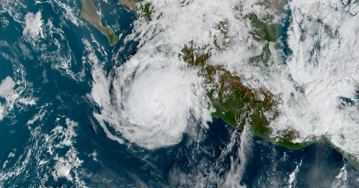
Trudy strengthened to 105 mph overnight and keeps a Hurricane Warning from Manzanillo to Cabo Corrientes. NHC expects it to pull away tonight and fall.

Key points
- At 5 a.m. MST Sunday, Hurricane Trudy had 105 mph winds. It was about 150 miles west of Manzanillo, Mexico, moving northwest at 10 mph along the coast, according to the National Hurricane Center.
- The Hurricane Warning still covers the coast from Manzanillo north to Cabo Corrientes. Mexico has dropped every watch and warning south of Manzanillo, and Tropical Storm Warnings stay up from north of Cabo Corrientes to San Blas and for Las Islas Marias.
- NHC still forecasts 4 to 8 inches of rain on the coast of Michoacan, Colima and Jalisco, with isolated totals near 12 inches. It expects Trudy to weaken rapidly from tonight and to be gone in three or four days.
Yesterday
Trudy got a little stronger overnight. In NHC's 2 a.m. MST discussion, the eye showed up more clearly on satellite and the deep thunderstorms had organized better, mostly on the west side of the storm. NHC raised the intensity to 90 knots, which matched the Dvorak satellite estimate from its own analysis branch. Twelve hours earlier the storm was at 100 mph and 976 mb. By the 5 a.m. advisory it was at 105 mph and 970 mb.
Trudy also turned out to be a bit smaller than the forecasters had thought. A satellite wind pass caught the east side of the storm and pointed to a tighter wind field, so NHC trimmed its wind radii. Tropical-storm-force winds now reach 105 miles from the center, down from 140 miles in Saturday evening's advisory. NHC said the outer rainbands were already crossing southwestern and west-central Mexico, "likely producing heavy rains and strong winds."
| Hurricane Trudy, NHC Intermediate Advisory 20A, 5 a.m. MST Sun Oct 18 | |
|---|---|
| Position | 18.9N 106.6W |
| Distance | about 150 mi W of Manzanillo, 120 mi SSW of Cabo Corrientes |
| Maximum winds | 105 mph, Category 2 |
| Pressure | 970 mb (28.65 in) |
| Motion | northwest (320 degrees) at 10 mph |
| Hurricane-force winds | out to 30 miles from the center |
| Tropical-storm-force winds | out to 105 miles from the center |
| Next complete advisory | 8 a.m. MST |
| Change since Saturday evening | Advisory 18A, 6 p.m. CST Sat | Advisory 20A, 5 a.m. MST Sun |
|---|---|---|
| Maximum winds | 100 mph | 105 mph |
| Pressure | 976 mb | 970 mb |
| Hurricane-force radius | 35 mi | 30 mi |
| Tropical-storm-force radius | 140 mi | 105 mi |
| Coast south of Manzanillo | Hurricane Watch and Tropical Storm Warning | all discontinued |
*Source: NWS National Hurricane Center, Hurricane Trudy Intermediate Advisory 20A (5 a.m. MST, 1200 UTC Oct 18), Discussion 20 (2 a.m. MST, 0900 UTC Oct 18), and Intermediate Advisory 18A (6 p.m. CST Oct 17). NHC moved Trudy's advisories from Central to Mountain time overnight. MST is UTC minus 7; CST is UTC minus 6.*
Today, officially
The hurricane is running parallel to the coast, so the hurricane zone stays where it was. The Hurricane Warning runs from Manzanillo north to Cabo Corrientes. NHC says hurricane conditions, especially in gusts, are likely there this morning. North of Cabo Corrientes, tropical storm conditions are expected on the mainland as far as San Blas this morning, and on Las Islas Marias this afternoon.
Rain is still the widest hazard. NHC forecasts 4 to 8 inches through the weekend along and near the coast of Michoacan, Colima and Jalisco, with isolated totals near 12 inches. It says that rain may cause flooding and mudslides, mostly on steep ground. The outer bands could bring 2 to 4 inches to the Guerrero and Nayarit coasts, with isolated totals near 6 inches. Where the wind blows onshore inside the warning areas, NHC expects storm surge and damaging waves. Swells will keep surf and rip currents rough along the coast for the next few days.
Then the storm gets a hostile neighborhood. The 2 a.m. discussion says stronger southwesterly wind shear and dry, stable air should start weakening Trudy later today, and "the weakening is expected to be rapid." Tonight the center should begin pulling away from the coast, then crawl south of Baja California Sur on Monday and Tuesday. NHC now has Trudy as a remnant low by Tuesday afternoon, about a day sooner than Saturday's forecast. It adds that "it would not be surprising if both of these occurred sooner than predicted," meaning the remnant low and the storm's end.
| NHC forecast, Discussion 20 (UTC) | Position | Winds |
|---|---|---|
| Sun Oct 18, 1800Z | 19.5N 106.9W | 105 mph |
| Mon Oct 19, 0600Z | 20.2N 107.5W | 80 mph |
| Mon Oct 19, 1800Z | 20.4N 107.9W | 65 mph |
| Tue Oct 20, 0600Z | 20.7N 108.5W | 45 mph |
| Tue Oct 20, 1800Z | 21.1N 109.2W | 35 mph, remnant low |
| Wed Oct 21, 0600Z | 21.6N 109.7W | 30 mph, remnant low |
| Thu Oct 22, 0600Z | dissipated |
| Product, NHC | Area | Status at 5 a.m. MST |
|---|---|---|
| Hurricane Warning | Manzanillo north to Cabo Corrientes | hurricane conditions likely this morning |
| Tropical Storm Warning | north of Cabo Corrientes to San Blas | tropical storm conditions expected this morning |
| Tropical Storm Warning | Las Islas Marias | tropical storm conditions expected this afternoon |
*All figures are as NHC states them. NHC tells people in the area to follow their national weather service, which for this coast is Mexico's.*
This is a morning summary, not emergency information. For live warnings see weather.gov and your local officials. National Hurricane Center: https://www.nhc.noaa.gov/
More from the Weather Beat
More from the Journal
 THE WEATHER BEAT
Severe Thunderstorm Watch for Philadelphia, Harrisburg, Baltimore and Washington until 8 p.m. as a fast cold front crosses the Mid-Atlantic
OCT 16
THE WEATHER BEAT
Severe Thunderstorm Watch for Philadelphia, Harrisburg, Baltimore and Washington until 8 p.m. as a fast cold front crosses the Mid-Atlantic
OCT 16
 THE WEATHER BEAT
Nor'easter expected off North Carolina this weekend: Coastal Flood Watches from Hatteras to Hampton Roads, Storm Watches offshore
OCT 16
THE WEATHER BEAT
Nor'easter expected off North Carolina this weekend: Coastal Flood Watches from Hatteras to Hampton Roads, Storm Watches offshore
OCT 16
 EXPLAINERS
Why Is the Sky Blue?
AUG 20
EXPLAINERS
Why Is the Sky Blue?
AUG 20
Follow the Journal: RSS · get it by email