THE WEATHER BEAT · OCT 29
One weak tornado near Danbury, Wisconsin, inside Wednesday's 5 percent line, and hail to 3 inches in Minnesota
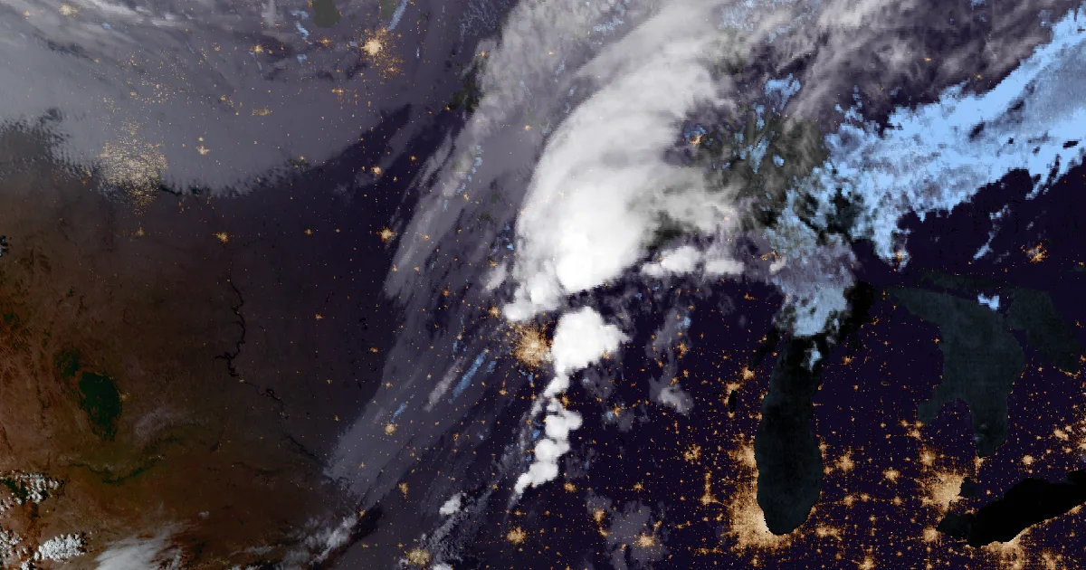
Wednesday's reader check answered: one preliminary tornado over Love Lake near Danbury, Wisconsin, with no damage reported, and a measured 3.00 inch.

Key points
- Wednesday's storms in Minnesota and Wisconsin left one preliminary tornado report. It came 3 miles southeast of Danbury, Wisconsin, at 5:40 p.m. CDT, inside the Storm Prediction Center's 5 percent tornado line from that morning.
- The Duluth office wrote it up as weak, brief rotation over Love Lake. It kicked up branches, leaves and water, and there was no damage as of the 6:03 p.m. report.
- Hail was the bigger story. The largest preliminary report was 3.00 inches, 2 miles southwest of Grove City, Minnesota, at 1:53 p.m. Severe storms are not forecast anywhere in the country today.
Yesterday
Wednesday morning's question was whether the clouds would win. The Twin Cities office had called the setup "a highly conditional threat." The Storm Prediction Center's 11:20 a.m. CDT outlook drew a 5 percent tornado area from the west side of the Twin Cities metro northeast into Wisconsin. By evening the answer was close to what both had said. One tornado was reported inside the line, and it was a small one.
It touched down in Burnett County, Wisconsin, 3 miles southeast of Danbury, at 5:40 p.m. The report came from the public. NWS Duluth describes "weak, brief rotation on the ground, kicking up small branches, leaves, and water as the rotation passed over Love Lake." It listed no damage as of 6:03 p.m. Trained spotters also reported two funnel clouds that did not count as tornadoes. One was at Randolph, Minnesota, just before 5 p.m., and the other was 2 miles south of Hammond, Wisconsin, at 5:30.
The afternoon belonged to hail. Storms crossed central Minnesota from Granite Falls through Kandiyohi and Meeker counties after midday. The largest stone was a measured 3.00 inches, 2 miles southwest of Grove City at 1:53 p.m. That spot is west of the tornado line but inside the outlook's broader hail area. Around 5 p.m. a second cell over Dakota County, south of the Twin Cities, produced 1.75 inch hail 3 miles west of Miesville. It also snapped a pine tree at Hillcrest Cemetery south of Hampton. At 6:48 p.m. the Bayfield County dispatch center reported multiple trees down around Cable, Wisconsin.
| Time (CDT) | Event | Place | Size or note | Source | Inside 5% tornado line |
|---|---|---|---|---|---|
| 12:36 p.m. | Hail | Granite Falls, Yellow Medicine MN | 1.00 in (est.) | Public | No |
| 1:21 p.m. | Hail | 4 NW Blomkest, Kandiyohi MN | 1.00 in (est.) | Public | No |
| 1:25 p.m. | Hail | 4 N Blomkest, Kandiyohi MN | 1.00 in | Public | No |
| 1:53 p.m. | Hail | 2 SW Grove City, Meeker MN | 3.00 in | Public | No |
| 1:55 p.m. | Hail | Grove City, Meeker MN | 1.00 in | Public | No |
| 2:27 p.m. | Hail | Kimball, Stearns MN | 0.75 in | Fire dept. | No |
| 3:36 p.m. | Hail | 3 SE Avon, Stearns MN | 0.88 in | Public | No |
| 4:00 p.m. | Hail | Mora, Kanabec MN | 1.00 in | Trained spotter | No |
| 4:00 p.m. | Hail | 2 E Sauk Rapids, Benton MN | 0.70 in | Fire dept. | No |
| 4:05 p.m. | Wind gust | 5 SW Gilman, Benton MN | 57 mph | Public | No |
| 4:21 p.m. | Hail | 4 W Hinckley, Pine MN | 0.70 in | Trained spotter | No |
| 4:28 p.m. | Hail | 2 E Pease, Mille Lacs MN | 0.75 in | Trained spotter | Yes |
| 4:57 p.m. | Funnel cloud | Randolph, Dakota MN | Storm chaser | Yes | |
| 5:00 p.m. | Wind damage | 1 S and 2 S Hampton, Dakota MN | Pine tree and limbs snapped; outbuilding roof damage | Trained spotter, public | Yes |
| 5:06, 5:08 p.m. | Hail | New Trier, Dakota MN | 1.50 in (two reports) | Trained spotter, public | Yes |
| 5:10 p.m. | Hail | 3 W Miesville, Dakota MN | 1.75 in | Trained spotter | Yes |
| 5:10 p.m. | Hail | 3 NW Miesville, Dakota MN | 1.25 in | Trained spotter | Yes |
| 5:17 p.m. | Wind damage | 3 W Miesville, Dakota MN | Trained spotter | Yes | |
| 5:30 p.m. | Funnel cloud | 2 S Hammond, St. Croix WI | Brief, along Highway T | Trained spotter | Yes |
| 5:40 p.m. | Tornado | 3 SE Danbury, Burnett WI | Weak, brief, over Love Lake; no damage as of 6:03 p.m. | Public | Yes |
| 6:48 p.m. | Wind damage | 1 NE Cable, Bayfield WI | Multiple trees down | 911 call center | No |
Sources: NWS Twin Cities/Chanhassen and NWS Duluth Preliminary Local Storm Reports, Wednesday, October 28, issued 12:35 p.m. to 8:51 p.m. CDT. SPC Day 1 probability points, PTSDY1 issued 11:20 a.m. CDT. The last column is the house's own check of each report's latitude and longitude against that outline. All reports are preliminary. Granite Falls was filed twice, and the second filing corrected the time, so it is counted once. The two New Trier reports may describe the same storm.
Today, officially
As of the Storm Prediction Center's 12:52 a.m. CDT Day 1 outlook, severe thunderstorms are not forecast anywhere in the U.S. today or tonight. The Twin Cities office had expected sunshine and highs in the 50s to lower 60s behind the front on Thursday. The wire's busiest hazard this morning is at sea: 162 Small Craft Advisories and 78 Gale Warnings. In Alaska, NWS Fairbanks and Anchorage have Winter Storm Warnings for the western Brooks Range and the northern Susitna Valley.
What the reader can check
A 5 percent tornado line means a 1 in 20 chance of a tornado within 25 miles of any point inside it. One weak report inside the line, and none outside it, is about what a low-end day looks like. Over the next few days, the Duluth office's storm reports will show whether anyone surveys the Love Lake touchdown or changes the 5:40 p.m. report.
This is a morning summary, not emergency information. For live warnings see weather.gov and your local officials, and the Storm Prediction Center for the current outlook.
The rock's live forecast for the places in this story
More from the Weather Beat
More from the Journal
 THE WEATHER BEAT
Florida's coastal flood watches become warnings from Nassau to Miami-Dade, and the Keys get major saltwater flooding
OCT 27
 THE WEATHER BEAT
The Rio Puerco and the San Juan crest below their highest forecasts, as the Purgatoire at Las Animas heads for its 1995 mark
OCT 27
 EXPLAINERS
Why Is the Sky Blue?
AUG 20
Follow the Journal: RSS · get it by email