THE WEATHER BEAT · OCT 28
A Slight severe risk for the Twin Cities and northwest Wisconsin Wednesday afternoon, with a few tornadoes possible
SPC's 11:20 a.m. CDT outlook puts a 5 percent tornado area over Minneapolis and St. Paul; NWS Twin Cities calls it a highly conditional threat, with rain.

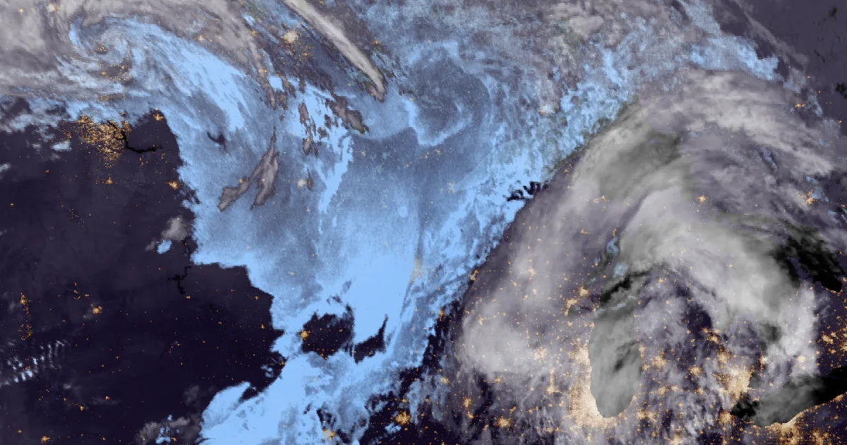
Key points
- The Storm Prediction Center's 11:20 a.m. CDT outlook puts parts of eastern Minnesota and northwest Wisconsin under a Slight Risk (level 2 of 5) of severe thunderstorms for Wednesday afternoon and early evening.
- The outlook says isolated tornadoes, severe hail and damaging winds are possible. Its 5 percent tornado area covers Minneapolis and St. Paul and runs northeast into Wisconsin past Rice Lake.
- NWS Twin Cities calls it "a highly conditional threat." The rain should leave its area before midnight, and Thursday looks drier and cooler.
Today, officially
On a late-October Wednesday, the Upper Midwest has a severe weather outlook. In the Storm Prediction Center's 11:20 a.m. CDT outlook, a surface low moves into south-central Minnesota by mid-afternoon, with a cold front trailing behind it. Storms that form near and just east of that low could turn severe across southern and eastern Minnesota into northwest Wisconsin this afternoon.
The forecasters aren't overselling it. SPC says the moisture is thin, with dew points mostly in the mid to upper 50s, which holds the energy for storms to weak levels. But the winds turn and strengthen with height, so any storm that stays rooted at the surface "may still support some risk for a couple of tornadoes." After that the outlook expects hail and gusty wind, then weakening storms as the day's heating fades.
The Twin Cities office wrote much the same in its 6:45 a.m. CDT discussion. It said "a few tornadoes are not unreasonable for today in eastern MN into western WI, particularly for the mid-late afternoon hours." In the same paragraph it said "this is also a situation where the ingredients simply do not come together." Persistent cloud cover could be what limits it. Highs run in the 60s to the lower 70s ahead of the front. The office expects all of the rain out of its area before midnight, with "a pretty good chance" of plenty of sunshine Thursday and highs in the 50s to lower 60s.
Farther south, a Marginal Risk runs into Iowa and eastern Nebraska, where SPC calls storm development "uncertain." Out west, Winter Weather Advisories from NWS Seattle, Portland, Pendleton and Spokane cover the Cascades into Wednesday afternoon and evening.
| Product | Issued | Area | What it says |
|---|---|---|---|
| SPC Day 1 Convective Outlook | 11:20 a.m. CDT Wed (1622Z) | Eastern MN into northwest WI | Slight Risk (2 of 5), valid to 7 a.m. CDT Thu |
| Tornado probability | same | Twin Cities metro northeast to near Rice Lake WI | 5 percent within 25 miles of a point |
| Hail probability | same | Central and eastern MN, into IA and eastern NE | 5 percent |
| Damaging wind probability | same | Eastern MN into northwest WI | 5 percent |
| Marginal Risk | same | Parts of IA and eastern NE | Conditional hail |
| NWS Twin Cities AFD | 6:45 a.m. CDT Wed | MPX area | "highly conditional threat"; rain out before midnight |
| Winter Weather Advisories | Wed morning | Cascades of WA and OR | Seattle, Portland, Pendleton, Spokane offices |
Sources: SPC Day 1 Convective Outlook and probability points (SPC AC 281620, PTSDY1 1120 AM CDT); NWS Twin Cities/Chanhassen Area Forecast Discussion 645 AM CDT; NWS active alerts via api.weather.gov. An outlook is a forecast of risk, not a report of storms.
What the reader can check
The 5 percent tornado line runs from the west side of the Twin Cities metro to near Rice Lake, Wisconsin. Thursday morning, SPC's preliminary storm reports will show whether any tornado was reported inside that line, or whether the clouds won, as the Twin Cities office allowed they might.
This is a summary, not emergency information. For live warnings see weather.gov and your local officials, and the Storm Prediction Center for the current outlook.
The rock's live forecast for the places in this story
More from the Weather Beat
More from the Journal
 THE WEATHER BEAT
A Flood Watch for every main Hawaiian island from Tuesday, with 2 to 8 inches of rain forecast through Thursday
OCT 26
 THE WEATHER BEAT
Hurricane force with no hurricane: what Monday's Bering Sea warning means, and the gale and storm bands under it
OCT 26
 EXPLAINERS
Why Is the Sky Blue?
AUG 20
Follow the Journal: RSS · get it by email