THE WEATHER BEAT · OCT 26
A Flood Watch for every main Hawaiian island from Tuesday, with 2 to 8 inches of rain forecast through Thursday
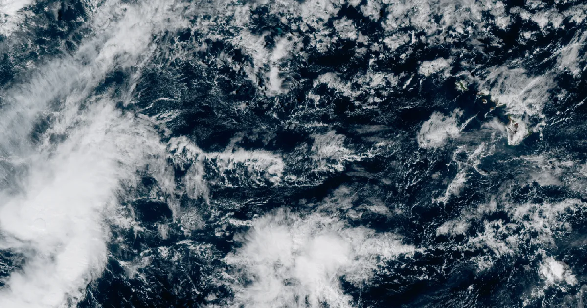
NWS Honolulu expects a stalled tropical trough to bring 2 to 8 inches Tuesday to Thursday; Tropical Storm Olana weakens to the southwest.

Key points
- NWS Honolulu has issued a Flood Watch for every main Hawaiian island, from Tuesday morning through late Wednesday night. Its 3:11 a.m. HST discussion forecasts 2 to 8 inches of rain from Tuesday through Thursday, with the most in the higher elevations.
- The source is a trough loaded with tropical moisture that the office expects to sit over the state for several days. The office also says the models still disagree on timing and position, so the uncertainty is "higher than normal."
- Tropical Storm Olana, southwest of the state, had 40 mph winds at its 11 p.m. HST Sunday advisory. The Central Pacific Hurricane Center expects it to weaken to a remnant low within about a day and a half and lists no hazards to land.
A wet week coming for the islands
Hawaii usually gets its rain from the trade winds: steady showers on the windward slopes and dry leeward coasts. The forecast for this week is different. At 3:05 a.m. HST Monday the Honolulu office issued a Flood Watch for all main islands, from Niihau and Kauai to the Big Island. It covers the whole chain, leeward zones included, from Honolulu Metro and the Ewa Plain on Oahu to Kona and Big Island East.
The office's morning discussion explains the setup. A large low sits about 800 miles northeast of the state. A trough runs southwest from it toward the islands, and the office expects that trough to stretch toward what is left of Olana and then drift north over Hawaii. It says the air moving in carries precipitable water "close to 2.5 inches," that the trough will "remain nearly stationary over the area through the end of the week," and that "a series of small lows will form with one or more potentially moving over the state." The office is plain about the limits of the forecast: "Models still show disagreement on timing and locations of these features. This makes the uncertainty higher than normal."
The watch text gives the risk. Heavy showers and a few thunderstorms "with intense rain rates" may begin Tuesday. Flood-prone roads and low areas may close as streams rise, and "urban areas may receive more significant flooding and property damage due to rapid runoff." The office says the watch may be extended past Wednesday. Its Monday forecast calls for trade winds to return this weekend, with rain still above normal.
The watch covers the zones that hold Honolulu, Hilo, Kailua-Kona, Kahului, Kaunakakai and Lanai City, and the forecast page for each town updates on its own.
| Item | What the product says | Product, time |
|---|---|---|
| Flood Watch | All main Hawaiian Islands, flash flooding from excessive rainfall possible | NWS Honolulu, 3:05 a.m. HST Mon |
| In force | 6 a.m. HST Tuesday through late Wednesday night (the alert lists an end of 5 a.m. HST Thursday) | Watch and AFD |
| Rain, Tue to Thu | 2 to 8 inches, highest in the higher elevations | AFD, 3:11 a.m. HST Mon |
| Moisture | precipitable water close to 2.5 inches | AFD |
| Thunderstorms | a few at times, brief gusty winds and very heavy rain with any of them | AFD |
| Beyond Wednesday | watch may be extended; trades return this weekend, rain above normal | AFD |
*Source: NWS Honolulu Flood Watch and Area Forecast Discussion on api.weather.gov, read at 13:50Z to 13:55Z October 26.*
Olana, and two readings of its path
The Central Pacific Hurricane Center's Advisory 4, at 11 p.m. HST Sunday, put Olana about 490 miles west-southwest of Johnston Island. It had 40 mph winds and was moving east at 7 mph. The advisory lists no coastal watches or warnings, and under hazards affecting land it says "None." The discussion calls the 35 knot intensity something that "could be generous" and forecasts Olana to become a remnant low by 36 hours and to dissipate by day 3. "Olana is expected to dissipate prior to reaching Johnston Atoll."
Honolulu's morning discussion describes Olana's part in the island forecast in different words. It says a trough to the northwest "will sag southeast helping pull Olana toward the islands," and that Olana "is expected to weaken into a tropical depression and stay to the west of the islands Tuesday." The two offices agree that Olana weakens. Where they differ is in how they describe its motion, and we report both as written. The rain in the Flood Watch comes from the trough, not from a landfall.
| Olana, Advisory 4 | Value |
|---|---|
| Time | 11 p.m. HST Sun Oct 25 (0900 UTC) |
| Position | 14.9N 176.6W, about 490 mi WSW of Johnston Island |
| Maximum winds | 40 mph |
| Movement | east, 95 degrees, at 7 mph |
| Pressure | 1002 mb |
| Tropical-storm-force winds | up to 45 miles from the center |
| Forecast | remnant low by 36 h, dissipated by 72 h |
| Next advisory | 5 a.m. HST Monday |
*Source: CPHC Tropical Storm Olana Advisory 4 and Discussion 4, issued by NWS National Hurricane Center Miami, read on api.weather.gov at 13:52Z October 26.*
Last night's numbers, checked
Sunday evening's story left two river numbers to check. Pueblo's 2:48 a.m. MDT warning had the Rio Grande at Alamosa, Colorado, at 9.9 feet at 2:30 a.m. That is above the 9.6 foot crest forecast on Sunday afternoon. The new forecast is a crest of 10.0 feet this morning. The product now compares that crest to 10.0 feet on May 23, 1948. Sunday's product had compared it to 9.9 feet on June 5, 1948. Near Bernardo, New Mexico, Albuquerque's 7:44 p.m. MDT warning forecast the Rio Puerco to crest at 24.2 feet just after midnight. It also said the river read 20.0 feet at 3 p.m. Sunday, with "no reliable observations available thereafter." So that crest has not been read yet.
| River point | Latest in the product | Forecast | Flood stage | Product, time |
|---|---|---|---|---|
| Rio Grande at Alamosa CO | 9.9 ft at 2:30 a.m. MDT Mon | crest 10.0 ft this morning, below flood stage Tuesday morning | 9.0 ft | NWS Pueblo, 2:48 a.m. MDT Mon |
| Rio Puerco near Bernardo NM | 20.0 ft at 3 p.m. MDT Sun, no reliable reading since | crest 24.2 ft just after midnight, below flood stage early Thursday | 19.5 ft | NWS Albuquerque, 7:44 p.m. MDT Sun |
*Source: NWS river Flood Warnings on api.weather.gov, read at 13:55Z October 26.*
What the reader can check
Honolulu's range is 2 to 8 inches between Tuesday and Thursday. The Thursday discussion and the rain totals that follow it will show where in that range the islands landed, and whether the watch was extended. The Weather School page on watches, warnings and advisories explains why a watch means flooding is possible and is not a promise that it will happen.
This is a summary, not emergency information. For live warnings see weather.gov and your local officials.
The rock's live forecast for the places in this story
More from the Weather Beat
More from the Journal
 THE WEATHER BEAT
The San Juan River's flood crest heads into Utah, due near 31 feet at Mexican Hat Sunday, after a record stage at Shiprock
OCT 24
 THE WEATHER BEAT
Five years ago this week, the Sierra took 10.4 inches of rain in a day at Blue Canyon, one of 25 wettest-day records
OCT 23
 EXPLAINERS
Why Is the Sky Blue?
AUG 20
Follow the Journal: RSS · get it by email