THE WEATHER BEAT · OCT 24
Hurricane Vance drops to 90 mph off southwest Mexico, with up to 10 inches of rain forecast for Colima, Michoacan and Jalisco
Cold water and wind shear broke Vance's eyewall on Saturday. NHC says a Tropical Storm Watch may be needed for Mexico's southwest coast, and its rain.

Key points
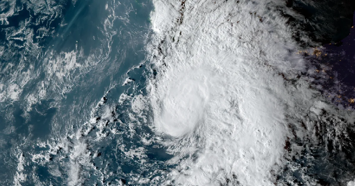
- At 3 p.m. CST Saturday, Hurricane Vance had 90 mph winds, down from 105 mph six hours earlier. It was about 335 miles southwest of Acapulco, Mexico, moving north-northwest at 6 mph, according to the National Hurricane Center.
- No coastal watches or warnings are in effect yet. NHC says a Tropical Storm Watch may be needed for parts of Mexico's southwestern coast tonight or on Sunday.
- Rain is the main hazard. NHC forecasts 4 to 6 inches through Thursday across Colima and western Michoacan and Jalisco, with isolated totals around 10 inches, and warns of flooding and mudslides on steep ground.
Yesterday
Vance lost a good deal of its structure on Saturday. NHC's 3 p.m. CST discussion says the storm "has become significantly less organized" because of two things: cold water near the center and stronger southwesterly wind shear. Microwave data showed the eyewall had broken open. The remaining thunderstorms were only on the north side, and visible satellite pictures put the low-level center near or just south of the southern edge of that storm mass.
NHC lowered the intensity to 80 knots, about 90 mph, and then said plainly that "this could be quite generous, as the current structure does not look much like a hurricane." At 9 a.m. the storm had 105 mph winds and a pressure of 970 mb. By 3 p.m. the pressure had risen to 977 mb. The wind field stayed the same size. Hurricane-force winds reach 30 miles from the center, and tropical-storm-force winds reach 150 miles.
| Hurricane Vance, NHC Advisory 14, 3 p.m. CST Sat Oct 24 | |
|---|---|
| Position | 13.3N 103.3W |
| Distance | about 335 mi SW of Acapulco, 400 mi S of Manzanillo |
| Maximum winds | 90 mph (80 kt; NHC calls this "quite generous") |
| Pressure | 977 mb (28.85 in) |
| Motion | north-northwest (340 degrees) at 6 mph |
| Hurricane-force winds | out to 30 miles from the center |
| Tropical-storm-force winds | out to 150 miles from the center |
| Watches and warnings | none in effect |
| Next complete advisory | 9 p.m. CST |
| Change through Saturday | Advisory 13, 9 a.m. CST | Advisory 14, 3 p.m. CST |
|---|---|---|
| Position | 12.9N 103.0W | 13.3N 103.3W |
| Maximum winds | 105 mph | 90 mph |
| Pressure | 970 mb | 977 mb |
| Rain forecast, through Thursday | 3 to 6 in, isolated near 10 in | 4 to 6 in, isolated near 10 in |
*Source: NWS National Hurricane Center, Hurricane Vance Advisory 13 (9 a.m. CST, 1500 UTC Oct 24), Advisory 14 (3 p.m. CST, 2100 UTC Oct 24), and Discussion 14 (3 p.m. CST, 2100 UTC Oct 24). CST is UTC minus 6.*
Today, officially
For the next half day or so, NHC expects the storm to keep weakening. The 3 p.m. discussion says Vance is crossing "a pool of colder water with temperatures near 27C that has been upwelled by several previous tropical cyclones," and moderate shear is working on it at the same time. Later, closer to the Mexican coast, the water warms to about 29C. NHC says that could allow the storm to strengthen a little again if the shear eases, and it shows 85 mph at 48 hours. It also says Vance could weaken more than forecast before it reaches that warmer water.
The track depends on how much of the storm holds together. Vance is moving into weak steering currents and should slow down over the next day or so. NHC says a weaker storm that gets sheared apart would drift more to the west-northwest, while a stronger, deeper one would keep creeping north. The guidance shifted west on Saturday, and NHC moved its track west with it. It says more westward shifts may be needed if Vance keeps losing organization. In its Key Messages, NHC says it is "too early to say what wind and storm surge impacts Vance may cause along the coast of Mexico."
The rain forecast is the most certain part. Vance is slow, and NHC expects heavy rain on Mexico's west coast from Michoacan to Jalisco through much of next week. It forecasts 4 to 6 inches through Thursday across Colima and the western parts of Michoacan and Jalisco, with isolated totals around 10 inches. NHC says that rain may produce life-threatening flooding and mudslides, especially on steep terrain. Swells from Vance will reach the coast of southern and southwestern Mexico this weekend and keep surf and rip currents dangerous into next week.
This is the same stretch of coast where Hurricane Trudy brought a Hurricane Warning a week ago.
| NHC forecast, Discussion 14 (UTC) | Position | Winds |
|---|---|---|
| Sun Oct 25, 0600Z | 14.0N 103.6W | 85 mph |
| Sun Oct 25, 1800Z | 14.9N 104.0W | 80 mph |
| Mon Oct 26, 0600Z | 15.6N 104.4W | 80 mph |
| Mon Oct 26, 1800Z | 16.0N 104.6W | 85 mph |
| Tue Oct 27, 0600Z | 16.4N 104.8W | 80 mph |
| Tue Oct 27, 1800Z | 17.0N 104.9W | 75 mph |
| Wed Oct 28, 1800Z | 18.1N 105.2W | 60 mph |
| Thu Oct 29, 1800Z | 19.3N 105.6W | 45 mph |
*All figures are as NHC states them. NHC tells people in the area to follow their national weather service, which for this coast is Mexico's.*
This is a morning summary, not emergency information. For live warnings see weather.gov and your local officials. National Hurricane Center: https://www.nhc.noaa.gov/
More from the Weather Beat
More from the Journal
 THE WEATHER BEAT
Jacksonville's Coastal Flood Watches become Warnings from the Georgia beaches to Flagler, Saturday through Monday
OCT 23
 THE WEATHER BEAT
Moenkopi Wash runs more than 9 feet above flood stage near Tuba City, and the Paria River peaks near 2,500 cubic feet per second
OCT 22
 EXPLAINERS
Why Is the Sky Blue?
AUG 20
Follow the Journal: RSS · get it by email