THE WEATHER BEAT · SEP 1
Edouard Strengthens Toward the Gulf Coast
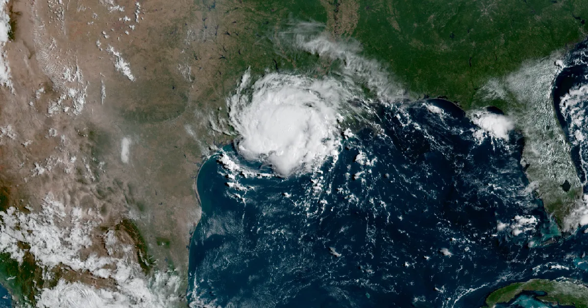
Tropical Storm Edouard is forecast near hurricane strength at the northwest Gulf Coast, with a Hurricane Watch and Storm Surge Warning for Texas and.

Key points
- Tropical Storm Edouard is forecast to strengthen, possibly to near hurricane strength, before reaching the northwest Gulf Coast later today; a Storm Surge Warning, a Hurricane Watch, and Tropical Storm Warnings cover the Texas and Louisiana coast per National Hurricane Center Advisory 4.
- Yesterday was one of the quietest severe weather days of the summer: 13 preliminary wind reports and one hail report nationwide, no tornadoes.
- The Storm Prediction Center carries a Slight Risk today from the central and northern Plains across the Midwest into Pennsylvania, New York, and New Jersey.
The rock's morning read on what the country's weather did yesterday, and what is officially expected today. Sources are the wire products themselves, cited as they read.
Yesterday: the depression got a name
The weather story of Monday, August 31 happened over water. At 7 p.m. CDT, the National Hurricane Center's Intermediate Advisory 2A announced that Tropical Depression Five had strengthened into Tropical Storm Edouard, about 140 miles southeast of Cameron, Louisiana. Three hours later, Advisory 3 at 10 p.m. CDT raised the stakes on the coast: a Storm Surge Warning from High Island, Texas to the Vermilion/Cameron Parish line, and a Hurricane Watch for a portion of the northwest Gulf Coast. The evening on land was the quiet before it, spent watching radar out of Lake Charles.
The rest of the country barely made a sound. Thirteen wind reports and one hail report came in all day, and no tornadoes anywhere. Most of the wind was monsoon outflow working the Four Corners and the High Plains. The one report with real damage behind it came from La Paz County, Arizona, where photos showed power poles down at Avenue 42E about six miles southeast of Bouse around 3 p.m. MST. The day's top measured gust was 77 mph at a personal weather station southeast of Lamar, Colorado at 6:30 p.m. MDT. The country's only hail fell at Kershaw-Ryan State Park near Caliente, Nevada: one-inch stones at 11:10 a.m. PDT.
The numbers
Report count for the day: 13 wind, 1 hail, 0 tornado. Reports ran from Juab County, Utah and La Paz County, Arizona through Alamosa, Prowers, Bent, Kiowa, and Cheyenne counties in Colorado, Cheyenne County in Kansas, Rio Arriba and Bernalillo counties in New Mexico, and Lincoln County, Nevada.
Top measured gusts, August 31:
| Gust | Location | County, State | Time |
|---|---|---|---|
| 77 mph | 7 SE Lamar | Prowers, CO | 6:30 p.m. MDT |
| 63 mph | 7 SE Lamar | Prowers, CO | 6:24 p.m. MDT |
| 63 mph | 5 S Sheridan Lake | Kiowa, CO | 6:44 p.m. MDT |
| 61 mph | 2 S Alamosa | Alamosa, CO | 5:11 p.m. MDT |
| 60 mph | 4 NW Levan | Juab, UT | 3:40 p.m. MDT |
| 60 mph | Albuquerque Intl Sunport | Bernalillo, NM | 8:01 p.m. MDT |
Source: Storm Prediction Center storm reports for the 12Z August 31 to 12Z September 1 period. All reports are preliminary; SPC labels them so and this brief does too. The Lamar gusts came from a personal weather station, per the report remarks; times are converted from UTC.
Today, officially
Edouard, landfall day
As of National Hurricane Center Advisory Number 4, issued 4 a.m. CDT Tuesday, September 1, the center of Tropical Storm Edouard sat about 65 miles south-southeast of Cameron, Louisiana and 90 miles southeast of Port Arthur, Texas, moving west-northwest at 8 mph with top sustained winds of 40 mph. The advisory's headline reads, "Edouard poised to significantly strengthen before reaching the northwest Gulf Coast later today." In its words: "Significant strengthening is forecast today and Edouard could approach hurricane strength before it reaches the northwest Gulf coast later today," and "the center of Edouard is forecast to reach the northwestern Gulf Coast within the warning area later today and move inland over southeast Texas tonight."
The watch and warning footprint, per that advisory:
- A Storm Surge Warning from High Island, Texas to the Vermilion/Cameron Parish line, Louisiana.
- A Hurricane Watch from High Island, Texas to Cameron, Louisiana.
- A Tropical Storm Warning from Port Bolivar, Texas to the Vermilion/Iberia Parish line, Louisiana.
On land, per NWS zone alerts active early Tuesday, the Tropical Storm Warning covered the Bolivar Peninsula, Chambers, Southern Liberty, Upper and Lower Jefferson, Orange, Hardin, Southern Jasper, and Southern Newton in Texas, and West Cameron, East Cameron, and Lower Vermilion in Louisiana. The Storm Surge Warning zones were Lower Jefferson County, Texas and West and East Cameron parishes, Louisiana; the Hurricane Watch zones were Lower Jefferson County and West Cameron Parish. A Flood Watch runs through 7 a.m. CDT Wednesday for southeast Texas counties including Harris, Galveston, Fort Bend, Brazoria, Montgomery, Liberty, Chambers, Walker, San Jacinto, Polk, Tyler, Hardin, Jasper, Newton, Jefferson, and Orange.
The Lake Charles Area Forecast Discussion, issued 1:05 a.m. CDT Tuesday, reads the landfall this way: the storm is "tracking toward Southeast Texas for a landfall near Sabine, TX by this afternoon," and "a hurricane watch has been added to Jefferson county and western Cameron Parish where the greatest wind threat will be." On the rain: "Heavy rainfall with the potential for flash flooding of urban areas will be possible around where the center of the low moves."
If you live in the footprint, official preparedness guidance lives at Ready.gov (https://www.ready.gov/), and the state emergency management agencies are the Texas Division of Emergency Management (https://tdem.texas.gov/) and Louisiana GOHSEP (https://gohsep.la.gov/).
Advisory vitals, per NHC Advisory 4 (4 a.m. CDT September 1):
| Item | Value |
|---|---|
| Position | 29.0N 92.8W, about 65 mi SSE of Cameron, LA |
| Max sustained winds | 40 mph |
| Central pressure | 1005 mb |
| Movement | WNW (300 degrees) at 8 mph |
| Forecast rainfall | 3 to 6 inches, isolated 9, Upper Texas Coast inland through east-central TX; 2 to 4 inches far southwest LA |
| Peak surge if at high tide | 3 to 5 ft High Island, TX to Vermilion/Cameron line, LA; 1 to 3 ft east to Morgan City, LA |
| Tornado note | "A tornado or two is possible this afternoon and evening over parts of southwest Louisiana and southeast Texas" |
| Next advisories | Intermediate 7 a.m. CDT, complete 10 a.m. CDT Tuesday |
The companion forecast discussion, same issue time, puts the expected landfall intensity at 55 knots and calls the intensity forecast "problematic," noting 31 C sea-surface temperatures and low wind shear in the storm's path. Storm page: https://www.nhc.noaa.gov/graphics_at5.shtml
Severe weather: a Slight Risk from the Plains to New Jersey
The Storm Prediction Center's Day 1 outlook, issued 1:03 a.m. CDT Tuesday and valid through 7 a.m. CDT Wednesday, carries a Slight Risk in two areas. As the summary reads: "Scattered strong to severe storms are possible over the central Plains and Midwest, as well as parts of New York, Pennsylvania and New Jersey." In the East, the outlook expects a mix of supercells and line segments across southern New York, Pennsylvania, and New Jersey through the afternoon, with damaging gusts and isolated hail the most likely hazards and, near the southern Hudson Valley, enough low-level shear that "a couple of tornadoes" are possible with the stronger storms. On the Plains, supercells along a stalled front over Nebraska and South Dakota could produce hail over two inches, damaging gusts, and "a tornado or two," with a storm cluster possibly running the front into eastern South Dakota and southern Minnesota through the evening.
Excessive rainfall
The Weather Prediction Center's Day 1 excessive rainfall outlook, issued 4:16 a.m. EDT Tuesday and valid through 8 a.m. EDT Wednesday, puts a Slight Risk of rainfall exceeding flash flood guidance over southeast Texas, the same ground Edouard's center crosses. Marginal Risk areas cover parts of the Northeast and mid-Atlantic (the same air the severe risk works), the Florida peninsula, a broader piece of Texas and Louisiana, and the monsoon country of the Southwest.
The rest of the tropics
Three more storms, all in the Pacific, none with coastal watches or warnings as of the advisories issued 9 UTC Tuesday:
| Storm | Advisory | Position | Winds | Pressure | Movement |
|---|---|---|---|---|---|
| Hurricane Karina | NHC No. 20 | 18.0N 127.9W, about 1,210 mi WSW of the southern tip of Baja California | 140 mph | 945 mb | WNW at 10 mph |
| Tropical Storm Lowell | CPHC No. 19 | 13.1N 148.5W, about 630 mi SE of Hilo, Hawaii | 70 mph | 993 mb | W at 10 mph |
| Tropical Storm Marie | NHC No. 1 | 13.8N 108.9W, about 470 mi SW of Manzanillo, Mexico | 45 mph | 1002 mb | NW at 9 mph |
Marie is new, named on its first advisory at 2 a.m. MST Tuesday, well offshore of southwest Mexico. The Lowell advisory headline reads, "LOWELL FORECAST TO BECOME A HURRICANE OVERNIGHT AND INTO TUESDAY." Hilo stays a name on that map, so the rock keeps reading the advisories.
Otherwise
Heat advisories stretched across the Midwest on Tuesday morning, from Kansas and Missouri through Iowa, Illinois, Indiana, and Ohio, in ordinary early-September numbers and below this brief's bar for news. No winter products of consequence, no widespread flood warnings.
---
This is a morning summary, not emergency information. For live warnings see https://www.weather.gov/ and your local officials.
The rock's live forecast for the places in this story
More from the Weather Beat
More from the Journal
 THE WEATHER BEAT
Watch or warning? Interior Alaska's snowstorm splits: the mountains now under warnings, Fairbanks still on a watch
OCT 19
THE WEATHER BEAT
Watch or warning? Interior Alaska's snowstorm splits: the mountains now under warnings, Fairbanks still on a watch
OCT 19
 THE WEATHER BEAT
Nor'easter stalls off North Carolina: Hatteras and Ocracoke flood warnings now run to Wednesday, Hampton Roads under advisories
OCT 19
THE WEATHER BEAT
Nor'easter stalls off North Carolina: Hatteras and Ocracoke flood warnings now run to Wednesday, Hampton Roads under advisories
OCT 19
 EXPLAINERS
Why Is the Sky Blue?
AUG 20
EXPLAINERS
Why Is the Sky Blue?
AUG 20
Follow the Journal: RSS · get it by email